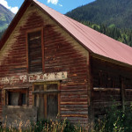
Connects: Lead King Loop, Crystal City Road (FSR #314), Crystal Mill Marble, CO – Ghost Town Crystal City, also called the Town of Crystal and Crystal Ghost Town, is an old town on the Lead King Loop accessed along Crystal…

Connects: Lead King Loop, Crystal City Road (FSR #314), Crystal Mill Marble, CO – Ghost Town Crystal City, also called the Town of Crystal and Crystal Ghost Town, is an old town on the Lead King Loop accessed along Crystal…
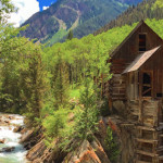
Connects: Lead King Loop, Crystal City Road (FSR #314), Crystal City (Town of Crystal) Marble, CO – Historic Mill The Crystal Mill, also called Sheep Mountain Tunnel Mill, is an old mill found along the Lead King Loop. The mill…
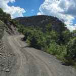
Connects: Gunnison County Road 3, Lead King Loop, Crystal City Road (FSR #314), Lead King Basin Road (FSR #315) Daniels Hill is a steep 0.75 mile rocky dirt section of Gunnison County Road 3 past Beaver Lake to the start…
Connects: Independence Pass Road (HWY 82), Roaring Fork River Aspen, CO – Rocky Area The Devil’s Punchbowl, a popular cliff jumping spot, is a section of large rocks where water pools along the Roaring Fork River near Independence Pass just…
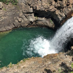
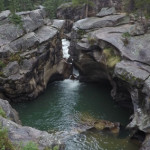
Connects: Schofield Pass Road (FSR #317), Crystal Bridge No. 4, South Fork Crystal River Marble, CO – Rocky Area The Devil’s Punchbowl, near Schofield Pass, is a popular cliff jumping spot where a section of large rocks creates water pools…
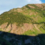
Connects: Maroon Bells-Snowmass Wilderness Marble, CO – Rocky Area The Devils Rockpile (10,702 ft) is a pillar class geographic survey feature in the Maroon Bells-Snowmass Wilderness of the White River National Forest near Marble, CO. More information about the Devils…
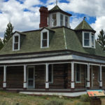
Connects: Twin Lakes (9,195 ft), Interlaken Trail, Interlaken Historic Resort Twin Lakes, CO – Historic The Dexter House at the Interlaken Historic Resort is an old house, originally called Dexter Cabin, that James Dexter and his family lived in while…
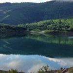
Connects: Dinkle Lake Road (FSR #311), Dinkle Lake Trail Basalt, Carbondale, CO – Lake Dinkle Lake (8,510 ft), also referred to as Lake Ann Reservoir, is a lake accessed by Dinkle Lake Road (FSR #311) near Basalt and Carbondale, CO.…
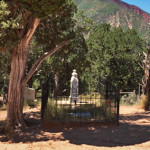
Connects: Pioneer Cemetery Trail, Linwood Cemetery Glenwood Springs, CO – Memorial Doc Holliday, famed dentist, gambler, and gunman is buried in Linwood Cemetery. John Henry “Doc” Holliday was born August 14, 1851 and died November 8, 1887. A stone at…
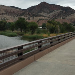
Connects: Dotsero (6,150 ft), Interstate 70, Dotsero Landing Dotsero, CO – Bridge The Dotsero Bridge is a bridge that spans the Colorado River. This is a bridge in Dotsero, CO. The old bridge, demolished in 2013, was listed on the…
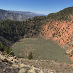
Connects: BLM Road 8460 Dotsero, CO – Rock The Dotsero Crater is a volcano, Colorado’s youngest volcano, where a large crater can be found. The Dotsero Volcano’s last eruption was just 4,200 years ago. This is a crater in Dotsero,…
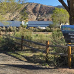
Connects: Dotsero (6,150 ft), Interstate 70, Dotsero Bridge Dotsero, CO – Recreation Area The Dotsero Landing is a recreation area along the Upper Colorado River near I-70 in Dotsero, CO. More information about Dotsero Landing can be found at: Aspen…
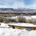
Connects: Watson Divide Road (CR 8) Old Snowmass, CO – Viewing Area The Dottie Fox Overlook (7,470 ft) is a 1.3 acre scenic overlook along Watson Divide Road (CR 8) with views of Snowmass Creek Valley in Old Snowmass, CO.…
Connects: Maroon Creek, Roaring Fork River, Burlingame Connector Trail (Rio Grande), Stein Trail Aspen, CO – Nature Preserve (Private) The Double Bar X Ranch Nature Preserve is a 17 acre private nature preserve in Aspen, CO. The preserve follows a…


