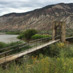
Connects: Dotsero (6,150 ft), Interstate 70 Dotsero, CO – Bridge The Bair Ranch Bridge is an old bridge on private property, Bair Ranch, that spans the Colorado River in Dotsero, CO. View Larger Map

Connects: Dotsero (6,150 ft), Interstate 70 Dotsero, CO – Bridge The Bair Ranch Bridge is an old bridge on private property, Bair Ranch, that spans the Colorado River in Dotsero, CO. View Larger Map
Connects: Transfer Trail Dotsero, CO – Medium – 29 Miles – Hike, Run, Mountain Bike, Dog Friendly – Dirt Coffee Pot Road (FSR #600) is an intermediate/moderate road you can hike, run, and mountain bike that is dog friendly. This…
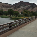
Connects: Dotsero (6,150 ft), Interstate 70, Dotsero Landing Dotsero, CO – Bridge The Dotsero Bridge is a bridge that spans the Colorado River. This is a bridge in Dotsero, CO. The old bridge, demolished in 2013, was listed on the…
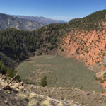
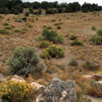
Connects: BLM Road 8460 Dotsero, CO – Rock The Dotsero Crater is a volcano, Colorado’s youngest volcano, where a large crater can be found. The Dotsero Volcano’s last eruption was just 4,200 years ago. This is a crater in Dotsero,…
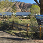
Connects: Dotsero (6,150 ft), Interstate 70, Dotsero Bridge Dotsero, CO – Recreation Area The Dotsero Landing is a recreation area along the Upper Colorado River near I-70 in Dotsero, CO. More information about Dotsero Landing can be found at: Aspen…
Connects: Colorado River Road (#301) Dotsero, CO – Medium – 2.5 Miles – Hike, Run, Mountain Bike, Horseback Ride, Dog Friendly – Dirt Dotsero-Ute Trail is an intermediate/moderate trail you can hike, run, mountain bike, and horseback ride that is…
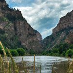
Connects: Glenwood Springs (5,760 ft), Colorado River, Glenwood Canyon Trail, Horseshoe Bend Park, Artist Point (6,540 ft), No Name Rest Area, No Name Trail (Jess Weaver Trail), No Name Canyon, Grizzly Creek Rest Area, Grizzly Creek Trail, Grizzly Creek Canyon,…


