Arbaney Traverse

Arbaney Traverse

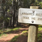
Connects: Basalt/Old Snowmass Trail, Arbaney Kittle Trail, Arbaney Kittle West Trail, Arbaney Kittle Gulch Trail, Fryingpan Overlook (8,290 ft), Triangle Peak Trail, Red Rim Road (FSR #534), Triangle Peak (9,223 ft), Red Canyon Trail, Kobey Trail, Forest Service Road #513,

Posted in 8-10+ Miles, Aspen, Basalt, Difficult, Dirt, Dog Friendly, Hard, Hiking, Horseback Riding, Large Loops/Backpacking, Lenado, More Than 10 Miles, Mountain Biking, Running, Trails, Woody Creek

Aspen to Crested Butte

Aspen to Crested Butte

Connects: Maroon Creek Road (CR 13), Maroon Creek Trail, Maroon Lake (9,585 ft), Maroon Bells Scenic Trail, Four Pass Loop, Crater Lake Trail, Crater Lake (10,076 ft), West Maroon Trail, West Maroon Pass (12,465 ft), East Maroon Trail, East Maroon

Posted in 8-10+ Miles, Aspen, Crested Butte, Difficult, Dirt, Dog Friendly, Gothic, Hard, Hiking, Horseback Riding, Large Loops/Backpacking, Maroon Bells-Snowmass Wilderness, More Than 10 Miles, Mountain Biking, Rocky, Running, Trails Tagged with:

Aspen to Marble

Aspen to Marble

Connects: Marble to Crested Butte, Four Pass Loop, Maroon Lake (9,585 ft), Buckskin Pass (12,462 ft), Snowmass Lake (10,980 ft), Trail Rider Pass (12,415 ft), Geneva Lake (10,940 ft), Lead King Loop, Beaver Lake (7,945 ft) Aspen, Marble, CO –

Posted in 8-10+ Miles, Aspen, Difficult, Dirt, Dog Friendly, Hard, Hiking, Horseback Riding, Large Loops/Backpacking, Marble, More Than 10 Miles, Running, Trails

Avalanche Creek Trail

Avalanche Creek Trail

Connects: Avalanche Creek Road (FSR #310), Avalanche Campground, Hell Roaring Trail, Duley Park, East Creek/Gift Creek Trail, Capitol Creek Trail, Silver Creek Trail, Avalanche Lake (10,695 ft) Carbondale, CO – Medium – 11 Miles – Hike, Run, Horseback Ride, Dog

Posted in 8-10+ Miles, Carbondale, Dirt, Dog Friendly, Hiking, Horseback Riding, Marble, Maroon Bells-Snowmass Wilderness, Medium, Moderate, More Than 10 Miles, Running Tagged with:

Boy Scout Loop

Connects: Scout Trail, Forest Hollow Trail, Hubbard Cave Road (FSR #408), Lookout Mountain Road (CR 120), Red Canyon Road (CR 115), Rio Grande Trail Glenwood Springs, CO – Hard – 18+ Miles – Hike, Run, Mountain Bike, Dog Friendly –

Posted in 8-10+ Miles, Difficult, Dirt, Dog Friendly, Glenwood Canyon, Glenwood Springs, Hard, Hiking, Large Loops/Backpacking, Lookout Moutain, More Than 10 Miles, Mountain Biking, Running, Trails

Carbondale to Crested Butte

Crystal Valley Trail

Connects: Highway 133 (West Elk Loop Scenic Byway), Crystal Valley Trail, Redstone (7,200 ft), Marble (8,000 ft), McClure Pass (8,755 ft), Kebler Pass (10,007 ft) Carbondale, CO – Hard – 74 Miles – Hike, Run, Mountain Bike, Horseback Ride, Dog

Posted in 8-10+ Miles, Carbondale, Crested Butte, Difficult, Dirt, Dog Friendly, Hard, Hiking, Horseback Riding, Large Loops/Backpacking, More Than 10 Miles, Mountain Biking, Paved, Road Biking, Running, Trails Tagged with: , , , ,

Castle Creek Road (CR 15)

Castle Creek Road

Connects: Marolt Trail, Castle Creek Trail (Proposed), Congo Trail, Midnight Mine Road (FSR #118), Conundrum Creek Trail, Little Annie Road (CR 15G), American Lake Trail, Express Creek Road (FSR #122), Ashcroft Ghost Town, River Run Trail, King Cabin, Ashcroft Ski

Posted in 8-10+ Miles, Ashcroft, Ashcroft Ski Touring System, Aspen, Classic XC Skiing, Dog Friendly, Easy, Medium, Moderate, More Than 10 Miles, Nordic (XC Ski), Paved, Road Biking, Skate Skiing, Snow, Snowshoeing, Trails Tagged with: , ,

Cattle Creek Loop

Cattle Creek Loop

Connects: Cattle Creek Road (CR 113), Crystal Springs Road (CR 112) Catherine Store Road (CR 100), Rio Grande Trail Carbondale, Glenwood Springs, CO – Medium – 20.5 Miles – Run, Hike, Road Bike, Mountain Bike – Paved/Gravel Cattle Creek Loop,

Posted in 8-10+ Miles, Carbondale, Glenwood Springs, Gravel, Large Loops/Backpacking, Medium, Moderate, More Than 10 Miles, Mountain Biking, Paved, Road Biking, Running, Trails Tagged with:

Coffee Pot Road (FSR #600)

Connects: Transfer Trail Dotsero, CO – Medium – 29 Miles – Hike, Run, Mountain Bike, Dog Friendly – Dirt Coffee Pot Road (FSR #600) is an intermediate/moderate road you can hike, run, and mountain bike that is dog friendly. This

Posted in 8-10+ Miles, Dirt, Dog Friendly, Dotsero, Flat Tops Wilderness, Hiking, Medium, Moderate, More Than 10 Miles, Mountain Biking, Running, Trails

Cottonwood Pass Road (CR 10A)

Cottonwood Pass Road

Connects: Cattle Creek Road (CR 113), Cottonwood Pass (8,290 ft), Red Table Road (FSR #514)

Posted in 4-7 Miles, 8-10+ Miles, Carbondale, Classic XC Skiing, Dirt, Dog Friendly, Easy, Fat Biking, Medium, Moderate, More Than 10 Miles, Mountain Pass, Nordic (XC Ski), Paved, Road Biking, Running, Snow, Snowshoeing, Trails, Winter Trail

Eagle-Thomasville Road (FSR #400)

Eagle-Thomasville Road

Connects: Frying Pan Road (CR 104), Spring Creek Ridge (FSR #519), Lime Park (9,300 ft), Burnt Mountain Road (FSR #506), Crooked Creek Reservoir (9,415 ft), Crooked Creek Pass (10,000 ft), Mount Thomas Trail, Sylvan Lake State Recreation Area Thomasville, CO

Posted in 8-10+ Miles, Basalt, Dirt, Dog Friendly, Eagle, Easy, Hiking, Horseback Riding, Meredith, More Than 10 Miles, Mountain Biking, Ruedi Reservoir, Running, Trails Tagged with:

East Maroon Trail

East Maroon Trail

Connects: Maroon Creek Road (CR 13), East Maroon Wilderness Portal, Maroon Creek Trail, East Maroon Pass (11,820 ft), Copper Lake (11,320 ft), Copper Creek Trail, Triangle Pass Trail Aspen, CO – Hard – 10.5 Miles – Hike, Run, Horseback Ride,

Posted in 10 Miles, 8-10+ Miles, Aspen, Difficult, Dirt, Dog Friendly, Hard, Hiking, Horseback Riding, Maroon Bells-Snowmass Wilderness, More Than 10 Miles, Running, Trails

Fisher Creek

Fisher Creek Area

Connects: Cattle Creek Road (CR 113), Red Canyon Road (CR 115), Fisher Cemetery Road (CR 62), Fisher Cemetery The Fisher Creek area, or Haff Pasture, is a Special Management Area with numerous routes and trails near Carbondale and Glenwood Springs,

Posted in 8-10+ Miles, Carbondale, Dirt, Dog Friendly, Glenwood Springs, Hiking, Horseback Riding, Medium, Moderate, More Than 10 Miles, Mountain Biking, Running, Trails Tagged with:

Four Mile Road (CR 117)

Connects: Midland Ave, Dry Park Road (CR 125), Sunlight Mountain, Four Mile Road (FSR #300) Glenwood Springs, CO – Medium – Road Bike – Paved Four Mile Road (CR 117) is an intermediate/moderate road you can bike. This is a

Posted in 8-10+ Miles, Glenwood Springs, Medium, Moderate, More Than 10 Miles, Paved, Road Biking, Sunlight Mountain Resort, Trails Tagged with:

Four Pass Loop (4 Pass Loop)

Four Pass Loop

Connects: Aspen to Crested Butte, Marble to Crested Butte, Three Pass Loop, Maroon Lake (9,585 ft), Maroon Bells Scenic Trail, Maroon-Snowmass Trail, Crater Lake Trail, Crater Lake (10,076 ft), West Maroon Trail, West Maroon Pass (12,465 ft), Frigid Air Pass

Posted in 8-10+ Miles, Aspen, Difficult, Dirt, Hard, Hiking, Horseback Riding, Large Loops/Backpacking, Maroon Bells-Snowmass Wilderness, More Than 10 Miles, Rocky, Running, Trails Tagged with: , , ,

Trail Search

Find a trail. Use 1 or all 4 drop downs to customize your search for the right trail.

Dog Friendly:

  or  

Park Search

Find a park. Use the drop downs to find the perfect park.

Dog Friendly:

  or  

Featured and Mentioned On

Questions? Email us at info@aspentrailfinder.com
By using this site you agree to the terms of our User Agreement. Read our Disclaimer.