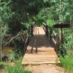
Connects: Hunter Valley Trail Aspen, CO – Bridge 10th Mountain Bridge is a pedestrian bridge over Hunter Creek in the Hunter Creek Valley. This is a bridge in Aspen, CO. Smuggler Mountain Printable Trail Map View Larger Map

Connects: Hunter Valley Trail Aspen, CO – Bridge 10th Mountain Bridge is a pedestrian bridge over Hunter Creek in the Hunter Creek Valley. This is a bridge in Aspen, CO. Smuggler Mountain Printable Trail Map View Larger Map
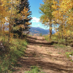
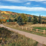
Connects: Smuggler Mountain, Smuggler Mountain Road (FSR #131), Lollipop Trail, Behind The Sign (BTS) Trail, Iowa Shaft Mine, Hunter Creek Cutoff Trail Aspen, CO – Medium – 0.40 Miles – Hike, Run, Mountain Bike, Dog Friendly – Dirt 10th Mountain…
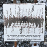
Connects: Aspen Mountain, North American Ski Run Aspen, CO – Memorial In April of 1968 Aspen hosted the 8th International Ski Congress. The International Ski (Interski) Congress is claimed to be the most important technical/academical meeting for snowports in the…
Connects: Aspen Mountain, Gretl’s Ski Run Aspen, CO – Shrine The 9/11 Shrine is dedicated to those who died in the terrorist attacks on September 11, 2001. The shrine is located on the right side of Gretl’s Ski Run on…
Connects: Cemetery Lane Trail, Bugsy Barnard Park, Across The Pond Park, Aspen Fat Bike Loop (Winter), Chatfield Trail, Old Stage Trail, Burlingame Trail, Annie B. Mitchell Trail, Owl Creek Trail View Larger Map View Larger Map
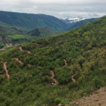
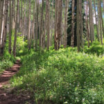
Connects: Buttermilk Connector Trail, Sky Mountain Park, Owl Creek Trail, Cozyline Trail, Skyline Ridge Trail Aspen, Snowmass Village, CO – Medium – 2 Miles – Hike, Run, Mountain Bike – Dirt Airline Trail is an intermediate/moderate trail you can hike,…
Connects: Highway 82, Roaring Fork River Aspen, CO – Hard – Hike, Dog Friendly – Rocky/Dirt The Airport Ranch Trail a difficult trail network providing fishing access to the Roaring Fork River you can hike that is dog friendly. This…
Connects: Midland Trail, Koch Lumber Park, Barbee Property Open Space, Aspen Mountain Summer Road (Aspen Mountain Trail), Little Nell Trail, Ute Mesa Trail, Ute Trail Aspen, CO – Easy – 1.5 Miles – Hike, Run, Mountain Bike, Dog Friendly –…
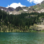
Connects: American Lake Trail Aspen, CO – Lake American Lake (11,365 ft) is an alpine lake in the Maroon Bells-Snowmass Wilderness accessed by the American Lake Trail. More information about American Lake can be found at: White River National Forest…
Connects: Castle Creek Road (CR 15), American Lake (11,365 ft) View Larger Map
Connects: Aspen Meadows Resort, The Aspen Institute, Anderson Park Aspen, CO – Viewing Area Amy’s Meadow is a 13.5 acre open space between the Aspen Meadows Resort and the Aspen Music Tent in Aspen, CO. This area is named after…
Connects: Petroleum & Anderson Lake Trail Aspen, CO – Lake Anderson Lake (11,830 ft) is an alpine lake accessed by the Petroleum & Anderson Lake Trail near Aspen, CO. This lake is in a non-wilderness area. Distances: Anderson Lake to…
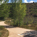
Connects: ABC Trail, Stein Trail Aspen, CO – Easy – 0.18 Miles – Walk, Run, Road Bike, Dog Friendly – Paved The Annie B. Mitchell Trail is an easy trail you can walk, run, and bike that is dog friendly.…
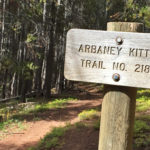
Connects: Basalt/Old Snowmass Trail, Arbaney Kittle Trail, Arbaney Kittle West Trail, Arbaney Kittle Gulch Trail, Fryingpan Overlook (8,290 ft), Triangle Peak Trail, Red Rim Road (FSR #534), Triangle Peak (9,223 ft), Red Canyon Trail, Kobey Trail, Forest Service Road #513,…
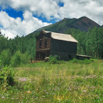
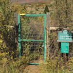
Connects: Castle Creek Road (CR 15), Express Creek Road (FSR #122), River Run Trail, Ashcroft Ski Touring Trails (Winter) Aspen, CO – Ghost Town The Ashcroft Ghost Town is a site 11 miles up Castle Creek Road near Aspen, CO.…


