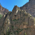
Connects: Interstate 70, Colorado River, Glenwood Canyon Glenwood Springs, CO – Viewing Area The American Flag in Glenwood Canyon is a flag on top of a rock cliff that can be seen along I-70 in the Glenwood Canyon. The flag…

Connects: Interstate 70, Colorado River, Glenwood Canyon Glenwood Springs, CO – Viewing Area The American Flag in Glenwood Canyon is a flag on top of a rock cliff that can be seen along I-70 in the Glenwood Canyon. The flag…
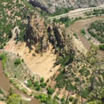
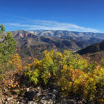
Connects: Glenwood Canyon, Scout Trail Glenwood Springs, CO – Viewing Area Artist Point (6,540 ft) is a scenic overlook above Horseshoe Bend Park in the Glenwood Canyon on the Scout Trail in Glenwood Springs, CO. Distances: Scout Trailhead (Sign) to…
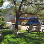
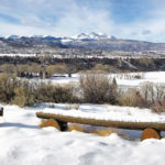
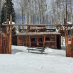
Connects: Midland Ave, Basalt History Tour Basalt, CO – Park Codgers Corner is a spot with benches and chairs where locals and visitors gather to talk about the past, present, and future. No smoking is allowed. This is a site…
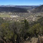
Connects: Colorow Trail New Castle, CO – Viewing Area The Colorow Overlook (6,590 ft) is a rocky spot that has a scenic overlook of the Town of New Castle. This is a site at the top of the Colorow Trail…
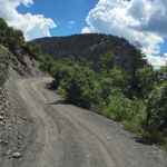
Connects: Gunnison County Road 3, Lead King Loop, Crystal City Road (FSR #314), Lead King Basin Road (FSR #315) Daniels Hill is a steep 0.75 mile rocky dirt section of Gunnison County Road 3 past Beaver Lake to the start…
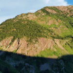
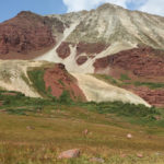
Connects: Maroon Bells-Snowmass Wilderness Marble, CO – Rocky Area The Devils Rockpile (10,702 ft) is a pillar class geographic survey feature in the Maroon Bells-Snowmass Wilderness of the White River National Forest near Marble, CO. More information about the Devils…
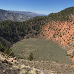
Connects: BLM Road 8460 Dotsero, CO – Rock The Dotsero Crater is a volcano, Colorado’s youngest volcano, where a large crater can be found. The Dotsero Volcano’s last eruption was just 4,200 years ago. This is a crater in Dotsero,…
Connects: Watson Divide Road (CR 8) Old Snowmass, CO – Viewing Area The Dottie Fox Overlook (7,470 ft) is a 1.3 acre scenic overlook along Watson Divide Road (CR 8) with views of Snowmass Creek Valley in Old Snowmass, CO.…
Connects: Three Pass Loop, East Snowmass Trail, Willow Lake Trail Snowmass, CO – Mountain Pass East Snowmass Pass (12,680 ft) is a mountain pass in the Maroon Bells-Snowmass Wilderness near Snowmass, CO. The pass is accessed by the East Snowmass…
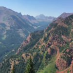
Connects: Elk Camp Chairlift, Snowmass Bike Park, Elk Camp Summit Trail, Vapor Trail, Elk Camp Uphill Route Snowmass, CO – Viewing Area The Elk Camp Overlook (11,340 ft), also called the Elk Camp Vista, is a scenic overlook of the…
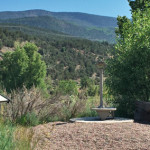
Connects: Emma Trail Basalt, CO – Viewing Area The Emma Overlook is bird watching spot with binoculars and a bench. The Emma Wetlands are an area for wildlife. This is a site in Basalt, CO. View Larger Map
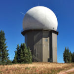
Connects: Red Table Road (FSR #514) Basalt, CO – Viewing Area The FAA Radar Tower on Red Table Mountain is a structure accessed along Red Table Road (FSR #514). View Larger Map
Connects: Buttermilk Mountain, No Problem Ski Run, No Problem Cabin Aspen, CO – Play Area Fort Frog was a wooden play structure located off of the No Problem Ski Run on Buttermilk Mountain in Aspen, CO. The structure was destroyed…
Connects: Arbaney Traverse, Arbaney Kittle Trail, Arbaney Kittle West Trail Basalt, CO – Viewing Area The Fryingpan Overlook (8,290 ft) is a scenic overlook of the Fryingpan Valley and popular turn around point on the Arbaney Kittle Trail in Basalt,…
Connects: Garfield Creek Road (CR 312), Baldy Creek Road (CR 328) New Castle, CO – Wildlife Area The Garfield Creek State Wildlife Area is an area near New Castle, CO. The area consists of two separate units: Garfield Creek and…


