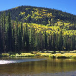
Connects: Grizzly Summer Road, Leonard’s Lookout Glenwood Springs, CO – Viewing Area Garl’s Landing is a chair and sitting area. This is a site along Grizzly Summer Road that follows Sunlight’s East Ridge to the top of Compass Peak near…

Connects: Grizzly Summer Road, Leonard’s Lookout Glenwood Springs, CO – Viewing Area Garl’s Landing is a chair and sitting area. This is a site along Grizzly Summer Road that follows Sunlight’s East Ridge to the top of Compass Peak near…
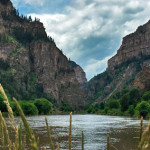
Connects: Glenwood Springs (5,760 ft), Colorado River, Glenwood Canyon Trail, Horseshoe Bend Park, Artist Point (6,540 ft), No Name Rest Area, No Name Trail (Jess Weaver Trail), No Name Canyon, Grizzly Creek Rest Area, Grizzly Creek Trail, Grizzly Creek Canyon,…
Connects: Hagerman Pass Road (FSR #105) Nast, CO – Viewing Area Hell Gate, also called Hell Gap, is a narrow section along Hagerman Pass Road (FSR #105) to Hell Gap where the valley drops far below and the road winds…
Connects: Richmond Hill Road (FSR #123), Upper Hurricane Road Aspen, CO – Viewing Area Hurricane Point (11,535 ft) is the top of Richmond Ridge accessed by Richmond Hill Road (FSR #123) on the backside of Aspen Mountain in Aspen, CO.…
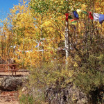
Connects: Kelley’s Trail Aspen, CO – Viewing Area Kelley’s Point is a bench placed in memory of John Kelley accessed along Kelley’s Trail in Aspen, CO. News about John Kelley can be found at: The Aspen Times (February 26, 2010)…
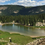
Connects: Thompson Divide, Lake Ridge Lakes Loop, Lake Ridge Lakes Trail Carbondale, CO – Lake The Lake Ridge Lakes are three lakes in the Thompson Divide accessed by the Lake Ridge Lakes Trail near Carbondale, CO. View Larger Map
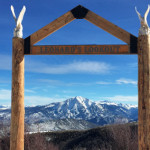
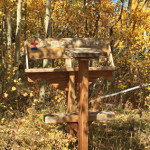
Connects: Sunlight Mountain, Grizzly Summer Road, Grizzly Ski Run, Garl’s Landing Glenwood Springs, CO – Viewing Area Leonard’s Lookout is a wooden structure with views of Mt. Sopris. This is a site along Grizzly Summer Road that follows Sunlight’s East…
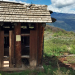
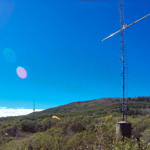
Connects: Scout Trail, Lookout Mountain Road (CR 120) Glenwood Springs, CO – Viewing Area Lookout Mountain Park (7,950 ft) is a site that includes picnic tables and a historic outhouse at the bottom of the radio towers on Lookout Mountain…
Connects: Crystal River, Gunnison County Road 3 Marble, CO – Airstrip The Marble Airstrip (7,800 ft), jokingly referred to as Marble International Airport, is a 4,000 foot airstrip in a private field between the Crystal River and Gunnison County Road…
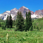
Connects: Maroon Creek Road (CR 13), Maroon Lake (9,585 ft), Maroon Bells Scenic Trail, Maroon Creek Trail (Maroon Bells), Four Pass Loop, Crater Lake Trail, Maroon-Snowmass Trail Aspen, CO – Recreation Area The Maroon Bells Scenic Area is an open…
Connects: Colorado Midland Trail, Hagerman Tunnel, Douglass City, Hagerman Lake (11,330 ft) Leadville, CO – Lake Opal Lake (11,390 ft) is a small alpine lake near the east portal of Hagerman Tunnel along the Colorado Midland Trail near Leadville, CO.…

Connects: Buckhorn Ski Run, Buckhorn Warming Hut, Westside Trail, Cherry Trail, Hidden Treasure Trail Aspen, CO – Viewing Area Peanut Butter Ridge is a spot on Aspen Mountain at the bottom of the Buckhorn Ski Run that overlooks the Castle…
Connects: Red Mountain Trail (Jeanne Golay Trail/Red Mountain Road), Grandstaff Trail, Cross Trail Glenwood Springs, CO – Viewing Area The Red Mountain Cross (7,450 ft) is a cross with lights on top of Red Mountain in Glenwood Springs, CO. The…
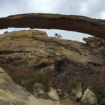
Connects: Rifle Arch Trail Rifle, CO – Rock Rifle Arch (6,580 ft) is a 60 foot high, 150 foot wide stone arch that rises off the Grand Hogback accessed by the Rifle Arch Trail in Rifle, CO. News about Rifle…
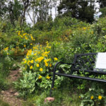
Connects: Smuggler Mountain, Smuggler Mountain Road (FSR #131) Aspen, CO – Viewing Area The Robbie Wade Picnic Area, also called Robbie Wade Park and Robbie Wade Shrine, is a picnic bench with a view on Smuggler Mountain in Aspen, CO.…


