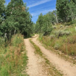
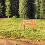
Connects: North Fork Road (FSR #501), Last Chance Trail, Tellurium Lake Trail, Harry Gates Hut, Woods Lake Road (FSR #507), Lime Park (9,400 ft), Eagle-Thomasville Road (FSR #400) Thomasville, CO – Easy – 10 Miles – Hike, Run, Mountain Bike,…

Connects: North Fork Road (FSR #501), Last Chance Trail, Tellurium Lake Trail, Harry Gates Hut, Woods Lake Road (FSR #507), Lime Park (9,400 ft), Eagle-Thomasville Road (FSR #400) Thomasville, CO – Easy – 10 Miles – Hike, Run, Mountain Bike,…
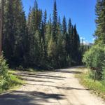
Connects: Norrie Road (FSR #504), Chapman Lake Trail, Chapman Gulch Trail Norrie, CO – Medium – 2.4 Miles – Hike, Run, Mountain Bike, Horseback Ride, Dog Friendly – Dirt Chapman Gulch Road (FSR #504E) is an intermediate/moderate road you can…
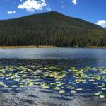
Connects: Chapman Lake Trail, South Fork Fryingpan Trail Nast, CO – Lake Chapman Lake (9,785 ft) is a lake near Nast accessed by Chapman Lake Trail in the Hunter-Fryingpan Wilderness. View Larger Map
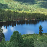
Connects: Frying Pan Road (CR 104), Chapman Campground Nast, CO – Reservoir Chapman Reservoir (8,545 ft) is a reservoir accessed in the Chapman Campground off of Frying Pan Road (CR 104) near Nast, CO. View Larger Map
Connects: Eagle-Thomasville Road (FSR #400), Mount Thomas Trail Thomasville, CO – Mountain Pass Crooked Creek Pass (10,009 ft) is a mountain pass along Eagle-Thomasville Road (FSR #400) near Basalt, CO. Distances: Crooked Creek Pass to Thomasville – 12 Miles Crooked…
Connects: Basalt State Wildlife Area, Strawberry Rock, Old Wagon Road, Toner Creek Road, Frying Pan Spring, Rocky Fork Day Use Area, Toilet Bowl, Ruedi Reservoir, Ruedi Trail, Meredith (7,830 ft), Thomasville (7,980 ft), Thomasville Lime Kilns, Eagle-Thomasville Road (FSR #400),…
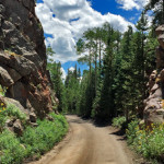
Connects: Frying Pan Road (CR 104), Hagerman Pass Road (FSR #105), Lily Pad Lake Trail, Marten Creek Trail, Fryingpan Lakes Trail More information about Fryingpan Lakes Road (FSR #505) can be found at: www.hutski.com – Fryingpan Drainage Trailheads View Larger…
Connects: Fryingpan Lakes Road (FSR #505), Lily Pad Lake Trail, Marten Creek Trail, Fryingpan Lakes (11,020 ft) Nast, CO – Medium – 4.5 Miles – Hike, Run, Horseback Ride, Dog Friendly – Dirt Fryingpan Lakes Trail is an intermediate/moderate trail…
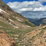
Connects: North Fork Trail Aspen, CO – Mountain Pass Fryingpan Pass (12,438 ft) is a high mountain pass accessed by the North Fork Trail. This is a mountain pass in the Mt. Massive Wilderness. Distances: North Fork Trailhead to Fryingpan…
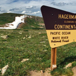
Connects: Hagerman Pass Road (FSR #105) Leadville, CO – Mountain Pass Hagerman Pass (11,925 ft) is a mountain pass along the continental divide accessed by Hagerman Pass Road (FSR #105) that connects Basalt to Leadville. Hagerman Pass Road is closed…
Connects: Burnt Mountain Road (FSR #506), Montgomery Flats Trail Thomasville, CO – Hut The Harry Gates Hut is a hut that is part of the 10th Mountain Division Hut System available for reservations through the 10th Mountain Division Hut Association.…
Connects: Hagerman Pass Road (FSR #105) Nast, CO – Viewing Area Hell Gate, also called Hell Gap, is a narrow section along Hagerman Pass Road (FSR #105) to Hell Gap where the valley drops far below and the road winds…
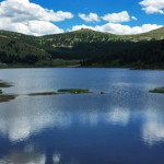
Connects: Ivanhoe Lake Road (FSR #527) Nast, CO – Lake Ivanhoe Lake (10,935 ft) is a lake along Ivanhoe Lake Road (FSR #527). The lake is located 2 miles from the intersection of Frying Pan Road and Hagerman Pass Road…


