Connects: Beaver Creek Trail (Rifle) View Larger Map

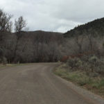
Beaver Creek Road (FSR #824)
Posted in 1-3 Miles, 2 Miles, Classic XC Skiing, Dirt, Dog Friendly, Easy, Medium, Moderate, Mountain Biking, Nordic (XC Ski), Rifle, Running, Skate Skiing, Snow, Snowshoeing, Trails
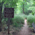
Beaver Creek Trail (Rifle)
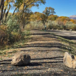
Connects: CR 317, Beaver Creek Road (FSR #824) Rifle, CO – Medium – 3.5 Miles – Hike, Run, Mountain Bike, Horseback Ride, Dog Friendly – Dirt Beaver Creek Trail is an intermediate/moderate trail you can hike, run, mountain bike, and…
Posted in 1-3 Miles, 3 Miles, Dirt, Dog Friendly, Hiking, Horseback Riding, Medium, Moderate, Mountain Biking, Rifle, Running, Trails
Bobcat Trail
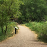
Connects: Rifle Fall State Park, Rifle Falls Caves, Coyote Trail, Cascades (Rifle), Rifle Falls Fish Hatchery Rifle, CO – Easy – 2 Miles – Hike, Dog Friendly – Paved/Dirt The Bobcat Trail is an easy trail you can hike that…
Posted in 1-3 Miles, 2 Miles, Dirt, Dog Friendly, Easy, Hiking, Rifle, Rifle Falls State Park, Trails
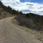
Buford-New Castle Road (FSR #245)
Connects: Grass Valley Road (CR 226), Mansfield Ditch Trail, Cherry Creek Trail, West Elk Trail, Forest Service Road #819, Last Chance Trail, Forest Service Road #820, Triangle Park, Buford New Castle, CO – Medium – 38.5 Miles – Road Bike,…
Posted in 8-10+ Miles, Dirt, Medium, Moderate, Mountain Biking, New Castle, Paved, Rifle, Road Biking, Trails Tagged with: BNC Road
Cascades (Rifle)
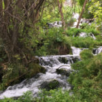
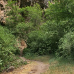
Connects: Rifle Falls State Park, Bobcat Trail Rifle, CO – Waterfall The Rifle Cascades (6,820 ft) are a series of rocks with flowing water on East Rifle Creek at the Rifle Falls Fish Hatchery near Rifle Falls State Park. This…
Cayton Ranger Station
Connects: Forest Service Road #800, Cayton Gulch Trail, Lake Fork Trail Silt, CO – Historic The Cayton Ranger Station, formerly known as the Johnson Springs Ranger Station and also called the Cayton Guard Station, is the second oldest ranger station…
Posted in Historic, Rifle, Sites Tagged with: Cayton Guard Station, Cayton Ranger Station, Johnson Springs Ranger Station
Clinetop Road (FSR #603)
Connects: Main Elk Road (CR 243), Hadley Gulch Trail, Clinetop Peak New Castle, CO – Medium – Hike, Run, Mountain Bike, Horseback Ride, Dog Friendly – Dirt Clinetop Road (FSR #603) is an intermediate/moderate road you can hike, run, mountain…
Posted in 4-7 Miles, Dirt, Dog Friendly, Hiking, Horseback Riding, Medium, Moderate, Mountain Biking, New Castle, Rifle, Running, Trails Tagged with: Clinetops
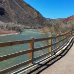
Colorado River Trail
Connects: Colorado River, Rifle Boat Ramp, Lion’s Park Circle Rifle, CO – Easy – Walk, Hike, Run, Dog Friendly – Gravel The Colorado River Trail is an easy trail you can walk and run that is dog friendly. This is…
Posted in 1-3 Miles, Dirt, Dog Friendly, Easy, Gravel, Hiking, Less Than A Mile, Rifle, Running, Trails, Walking Tagged with: Rifle Rest Area Trails
Coyote Trail
Connects: Rifle Falls State Park, Rifle Falls (6,550 ft), Mountain Mist Amphitheater, Rifle Falls Caves, Bobcat Trail, Squirrel Trail Rifle, CO – Easy – 2 Miles – Hike, Dog Friendly – Paved/Dirt The Coyote Trail is an easy trail you…
Posted in 1-3 Miles, 2 Miles, Dirt, Dog Friendly, Easy, Hiking, Paved, Rifle, Rifle Falls State Park, Trails
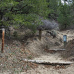
Koper’s Trail
Connects: Rifle Creek Road (CR 217), Lower Ice Cave, Old Tree Slab (Winter), Upper Ice Cave, Full Metal Jacket (Winter), The Final Curtain (Winter) View Larger Map
Posted in 1 Mile, 1-3 Miles, Climbing, Dirt, Dog Friendly, Easy, Hiking, Less Than A Mile, Rifle, Rifle Mountain Park, Rocky, Snow, Snowshoeing, Trails Tagged with: Rifle Mountain Park Ice Caves
Lower Ice Cave
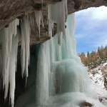
Connects: Koper’s Trail, Upper Ice Cave Rifle, CO – Ice Cave The Lower Ice Cave is an open area of rock where ice covers the front to create an ice cave. This is a winter site found along Koper’s Trail…
Posted in Cave, Ice, Ice Cave, Rifle, Rifle Mountain Park, Sites, Snow, Snowshoeing, Winter Site Tagged with: Ice Palace, Rifle Mountain Park Ice Caves
Lower Valley Trail (LoVa Trail)
Connects: South Canyon, South Canyon Bridge, South Canyon Archery Range, South Canyon Creek Road (CR 134) Glenwood Springs, CO – Easy – 50 Miles – Paved The Lower Valley Trail, or LoVa Trail, is a proposed 50-mile path along the…
Posted in Dog Friendly, Glenwood Springs, New Castle, Rifle, Trails Tagged with: LOVA Trail, Lower Valley Trails
Mansfield Ditch Trail
Connects: Buford-New Castle Road (FSR #245), Cherry Creek Trail, Forest Service Road #820, Forest Service Road #819, Spring Cow Camp Cabin, Deep Creek Canyon, Calhoun Basin New Castle, CO – Medium – 9.5 Miles – Hike, Run, Mountain Bike, Horseback…
Posted in 8-10+ Miles, 9 Miles, Dirt, Dog Friendly, Hiking, Horseback Riding, Medium, Moderate, Mountain Biking, New Castle, Rifle, Running, Trails
Morrow Draw Trail
Rifle, CO – Easy – 0.75 Miles – Walk, Hike, Run, Mountain Bike – Gravel Morrow Draw Trail is an easy trail you can walk, run, and bike that is dog friendly. This is a 0.75 mile gravel trail in…
Posted in 1-3 Miles, Dog Friendly, Easy, Gravel, Hiking, Less Than A Mile, Mountain Biking, Rifle, Running, Trails, Walking
Rifle Arch (6,580 ft)
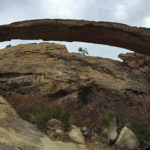
Connects: Rifle Arch Trail Rifle, CO – Rock Rifle Arch (6,580 ft) is a 60 foot high, 150 foot wide stone arch that rises off the Grand Hogback accessed by the Rifle Arch Trail in Rifle, CO. News about Rifle…


