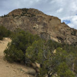
Connects: Government Road (HWY 13), Rifle Arch (6,580 ft) Rifle, CO – Medium – 1.5 Miles – Hike – Dirt Rifle Arch Trail is an intermediate/moderate trail you can hike. This is a 1.5 mile dirt trail to Rifle Arch…

Connects: Government Road (HWY 13), Rifle Arch (6,580 ft) Rifle, CO – Medium – 1.5 Miles – Hike – Dirt Rifle Arch Trail is an intermediate/moderate trail you can hike. This is a 1.5 mile dirt trail to Rifle Arch…
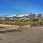
Connects: Colorado River, Colorado River Trail Rifle, CO – Recreation Area The Rifle Boat Ramp is a boat put in and trail network along the Colorado River in Rifle, CO. In 2016, the boat ramp was moved to be located…
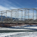
Connects: Colorado River Rifle, CO – Bridge The Rifle Bridge is a historic bridge built in 1909. This bridge is listed on the National Register of Historic Places. A sign on the bridge reads, “Bridge closed to all traffic trespassers…
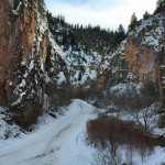
Connects: Highway 325, The Cleft (Winter), The Angel (Winter), Stone Free (Winter), The Ice Palace (Winter), Rifle Mountain Park, Soul On Ice (Winter), Old Man’s Climb (Winter), Koper’s Trail, Lower Ice Cave, Training Wheels (Winter), Old Maid’s Kitchen (Winter), Old…
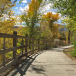
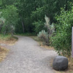
Connects: Centennial Park, Metro Park, Deerfield Park Rifle, CO – Easy – 2 Miles – Walk, Run, Road Bike, Dog Friendly- Paved Rifle Creek Trail is an easy trail you can walk, run, and bike that is dog friendly. This…
Connects: Government Road (CR 13), Estes Gulch, Hogback Ridge Trail Rifle, CO – Historic The Rifle Disposal Site is a 71-acre radioactive tailings disposal mound built by the Department of Energy for the interment of 3.5 million cubic yards of…
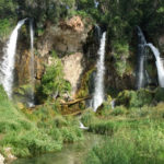
Connects: Rifle Falls State Park, Coyote Trail, Mountain Mist Amphitheater, Rifle Falls Caves, Bobcat Trail, Squirrel Trail Rifle, CO – Waterfall Rifle Falls (6,550 ft) is a 70-foot triple waterfall flowing over a dam on East Rifle Creek in Rifle…
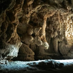
Connects: Rifle Falls State Park, Rifle Falls, Coyote Trail, Bobcat Trail Rifle, CO – Caves The Rifle Falls Caves are two limestone caves in the Rifle Falls State Park. Both caves are located a short distance from Rifle Falls off…
Connects: Highway 325, Rifle Falls (6,550 ft), Squirrel Trail, Coyote Trail, Mountain Mist Amphitheater, Bobcat Trail, Cascades (Rifle), Rifle Falls State Fish Hatchery Rifle, CO – Recreation Area Rifle Falls State Park is a 48-acre park located 13 miles off…
Connects: Highway 325, Rifle Gap State Park, Lakeview Campground, Cedar Campground, Pinyon Campground, Sage Campground Rifle, CO – Rock Rifle Gap is a narrow pass through the Grand Hogback that goes to Rifle Gap State Park located 10 miles off…
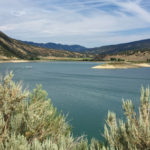
Connects: Highway 325, Rifle Gap, Rifle Gap Reservoir, Lakeview Campground, Cedar Campground, Pinyon Campground, Sage Campground Rifle, CO – Recreation Area Rifle Gap State Park is a 350-acre reservoir that provides boating, fishing, and swimming located 10 miles off I-70…
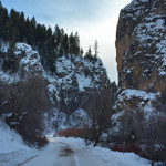
Connects: Rifle Creek Road (CR 217), Koper’s Trail, Lower Ice Cave, Upper Ice Cave Rifle, CO – Recreation Area To get to the park from downtown Rifle, take Railroad Avenue (which becomes Highway 13) north through the city. Take a…
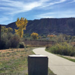
Connects: Colorado River, Rifle Boat Ramp, Rifle Rest Area Park, Lion’s Park Circle Rifle, CO – Easy – 0.75 Miles – Walk, Hike, Run, Bike, Dog Friendly – Gravel The Rifle Ponds Wildlife Viewing Trail is an easy trail you…
Connects: East Elk Creek Trail (Centennial Trail) New Castle, CO – Medium – 5.8 Miles – Hike, Run, Horseback Ride, Dog Friendly – Dirt Spring Creek Trail #2068 is an intermediate/moderate trail you can hike, run, and horseback ride that…
Connects: Rifle Falls State Park, Coyote Trail More information about the Rifle Falls State Park can be found at: Colorado Parks & Wildlife – Rifle Falls Trails Squirrel Trail Map Rifle Falls State Park View Larger Map


