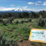
Connects: Colorado Mountain College (Spring Valley Campus) Glenwood Springs, CO – Disc Golf The Colorado Mountain College Spring Valley Disc Golf Course is an 18 hole frisbee golf course in Glenwood Springs, CO. View Larger Map

Connects: Colorado Mountain College (Spring Valley Campus) Glenwood Springs, CO – Disc Golf The Colorado Mountain College Spring Valley Disc Golf Course is an 18 hole frisbee golf course in Glenwood Springs, CO. View Larger Map
Connects: Highway 133 (West Elk Loop Scenic Byway), Coal Creek Road (FSR #307), Redstone Coke Ovens Redstone, CO – Memorial The Coal Basin Monument is a tribute to the miners of Coal Basin. This is a monument in Redstone, CO.…
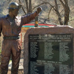
Connects: Burning Mountain Park, Vulcan Mine New Castle, CO – Memorial The Coal Miner Memorial is a memorial to the victims of the New Castle mining explosions of the Vulcan Mine. This is a memorial at Burning Mountain Park in…
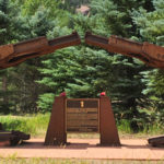
Connects: Midland Ave, Basalt History Tour Basalt, CO – Park Codgers Corner is a spot with benches and chairs where locals and visitors gather to talk about the past, present, and future. No smoking is allowed. This is a site…
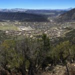
Connects: Colorow Trail New Castle, CO – Viewing Area The Colorow Overlook (6,590 ft) is a rocky spot that has a scenic overlook of the Town of New Castle. This is a site at the top of the Colorow Trail…
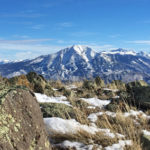
Connects: Sunlight Mountain, Compass Trail Glenwood Springs, CO – Mountain Peak Compass Peak (9,895 ft) is the peak on Sunlight Mountain Resort. This is a mountain peak near Glenwood Springs, CO. View Larger Map
Connects: Aspen Mountain, Silver Queen Ski Run Aspen, CO – Mine Compromise Mine is an old silver mine on Aspen Mountain, above the Little Nell ski run, in Aspen, CO. The mine is not open to the public. News about…
Connects: Conundrum Creek Trail Aspen, CO – Hot Springs The Conundrum Hot Springs (11,230 ft) is a natural hot springs along Conundrum Creek accessed by the Conundrum Creek Trail. This is a hot spring in the Maroon Bells-Snowmass Wilderness near…
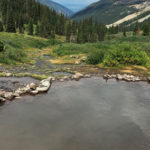
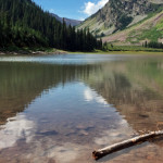
Connects: Copper Creek Trail, East Maroon Trail, Triangle Pass Trail Gothic, CO – Lake Copper Lake (11,320 ft) is an alpine lake just below East Maroon Pass (11,820 ft) in the Maroon Bells-Snowmass Wilderness accessed primarily by the Copper Creek…
Connects: Cottonwood Pass Road (CR 10A) Carbondale, CO – Mountain Pass Cottonwood Pass (8,290 ft) is a mountain pass accessed by Cottonwood Pass Road (CR 10A) near Carbondale, CO. There are no signs that mark the peak of Cottonwood Pass.…
Connects: Cattle Creek Road (CR 113), Cottonwood Pass (8,290 ft), Red Table Road (FSR #514)
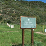
Connects: Cozy Point Open Space, Cozy Point Trail Aspen, CO – Archery Range Cozy Point Archery Range is a bow and arrow shooting range in the Cozy Point Open Space in Aspen near Woody Creek, CO. View Larger Map
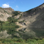
Connects: Four Pass Loop, Crater Lake Trail, Maroon-Snowmass Trail, West Maroon Trail Aspen, CO – Lake Crater Lake (10,076 ft) is an alpine lake in the Maroon Bells-Snowmass Wilderness accessed by the Crater Lake Trail (a section of the Maroon-Snowmass…
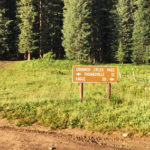
Connects: Eagle-Thomasville Road (FSR #400), Mount Thomas Trail Thomasville, CO – Mountain Pass Crooked Creek Pass (10,009 ft) is a mountain pass along Eagle-Thomasville Road (FSR #400) near Basalt, CO. Distances: Crooked Creek Pass to Thomasville – 12 Miles Crooked…
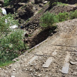
Connects: Schofield Pass Road (FSR #317), Devil’s Punchbowl (Schofield Pass), South Fork Crystal River Marble, CO – Bridge Crystal Bridge No. 4 is a bridge that crosses the South Fork Crystal River along Schofield Pass Road (FSR #317) near the…


