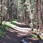
Connects: Arbaney Traverse, Triangle Peak Trail, Triangle Peak (9,223 ft), Red Canyon Trail, Arbaney Kittle Trail Aspen, CO – Hard – 5.9 Miles – Hike, Run, Mountain Bike, Dog Friendly – Dirt Red Rim Road (FSR #534) is a difficult…

Connects: Arbaney Traverse, Triangle Peak Trail, Triangle Peak (9,223 ft), Red Canyon Trail, Arbaney Kittle Trail Aspen, CO – Hard – 5.9 Miles – Hike, Run, Mountain Bike, Dog Friendly – Dirt Red Rim Road (FSR #534) is a difficult…
Connects: Cottonwood Pass Road (CR 10A), Milepost One Trail, Green Gate Trail, Taylor Creek Road (FSR #510), Red Table Trail, FAA Radar Tower, Mount Thomas Trail, Ruedi Trail Basalt, Carbondale, CO – Hard – Hike, Run, Mountain Bike, Horseback Ride,…
Connects: Taylor Creek Road (FSR #510), Basalt Mountain Trail, Cattle Creek Trail Basalt, CO – Hard – 5 Miles – Hike, Run, Mountain Bike, Horseback Ride, Dog Friendly – Dirt Red Table Trail #1909 is a difficult trail you can…
Connects: Lead King Loop, Lead King Basin Road (FSR #315), Crystal City Road (FSR #314), Crystal Bridge No. 4, Devil’s Punchbowl (Schofield Pass), Schofield Park, West Maroon Trail, Schofield Pass (10,700 ft) Marble, CO – Hard – 8 Miles –…
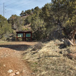
Connects: Boy Scout Loop, Artist Point (6,540 ft), Forest Hollow Trail, Lookout Mountain Park, Lookout Mountain Road (CR 120) Glenwood Springs, CO – Hard – Hike, Run, Mountain Bike, Dog Friendly – Dirt The Scout Trail, also referred to as…
Connects: Sunnyside Trail, Red Mountain Road (FSR #130.3) Aspen, CO – Hard – 2.6 Miles – Hike, Run, Mountain Bike, Horseback Ride, Dog Friendly – Dirt Shadyside Trail #1988 is a difficult trail you can hike, run, mountain bike, and…
Connects: Prince Creek, Prince Creek Road (CR 5, 111), Creekside Trail, Skill Saw Trail Carbondale, CO – Hard – 1.75 Miles – Hike, Run, Mountain Bike, Dog Friendly – Dirt Skull Bucket Trail is a difficult trail you can hike,…
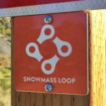
Connects: Snowmass Recreation Center, Rodeo Park, Snowmass Skate Park, Brush Creek Trail, Sky Mountain Park, Ditchline Trail, Viewline Trail, Deadline Trail (Downhill Only), Highline Trail, Tom Blake Trail, Anaerobic Nightmare Trail, Powerline Trail, Verde Trail, Government Trail, Cross Mountain Trail…
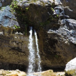
Connects: Hanging Lake Trail, Hanging Lake (7,175 ft) Glenwood Springs, CO – Waterfall Spouting Rock (7,323 ft) is a water fall gushing through rocks that flows into Hanging Lake. The site is located at the top of the Hanging Lake…
Connects: Little Annie Road (CR 15G), Dick Cabins, Dick Picnic Area, Quien Sabe Mine, Storm King Cabin Aspen, CO – Hard – Hike, Run, Dog Friendly – Dirt Stirling Wilderness Trail, also called Stirling Cooper Trail, is a difficult trail…
Connects: Buttermilk Summer Road, Buttermilk Trail, West Buttermilk Warming Hut, West Buttermilk Trail, Government Trail Aspen, CO – Hard – 1.7 Miles – Hike, Run, Mountain Bike, Dog Friendly – Dirt The Sugar Bowls Trail is a difficult trail you…
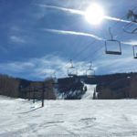
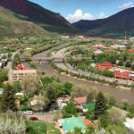
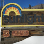
Glenwood Springs, CO – Hard – 1.5 Miles – Uphill, Snowshoe – Snow Sun King Uphill Route is a difficult route you can skin and snowshoe up. This is a 1.5 mile uphill route on Sunlight Mountain in Glenwood Springs,…
Connects: Babbish Trail, Babbish Express Trail, Compass Peak (9,895 ft), Compass Trail, Dippsy Doodle Trail, Garl’s Landing, Glades Trail, Grizzly Summer Road, High Places Chapel, Holiday Hill Trail, Leonard’s Lookout, Little Beaver Trail, Old Four Mile Road, Sun King Uphill…
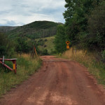
Connects: Highway 133 (West Elk Loop Scenic Byway), Penny Hot Springs, The Narrows Carbondale, CO – Hard – Hike – Rocky The Narrows Trail is a difficult trail you can hike that leads to the climbing area known as The…
Connects: Four Pass Loop, Divide Way, Maroon-Snowmass Trail, Snowmass Lake (10,980 ft), Buckskin Pass (12,462 ft), Willow Lake Trail, Willow Pass (12,570 ft), East Snowmass Trail, East Snowmass Pass (12,680 ft) Snowmass, CO – Hard – 23 Miles (Round Trip)…


