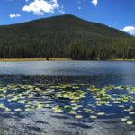
Connects: Chapman Lake Trail, South Fork Fryingpan Trail Nast, CO – Lake Chapman Lake (9,785 ft) is a lake near Nast accessed by Chapman Lake Trail in the Hunter-Fryingpan Wilderness. View Larger Map

Connects: Chapman Lake Trail, South Fork Fryingpan Trail Nast, CO – Lake Chapman Lake (9,785 ft) is a lake near Nast accessed by Chapman Lake Trail in the Hunter-Fryingpan Wilderness. View Larger Map
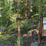
Connects: Chapman Gulch Road (FSR #504E), Chapman Lake (9,785 ft) Meredith, CO – Easy – 0.7 Miles – Hike, Dog Friendly – Dirt Chapman Lake Trail is an easy trail you can hike that is dog friendly. This is a…
Connects: Aspen Mountain, West Side Trail, Aspen Mountain Summer Road (Aspen Mountain Trail), Buckhorn Warming Hut, Peanut Butter Ridge Aspen, CO – Medium – Hike, Run, Mountain Bike, Dog Friendly – Dirt The Cherry Trail is an intermediate/moderate trail you…
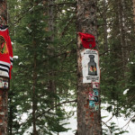
Connects: Snowmass Ski Area, Gunner’s View Ski Run Snowmass Village, CO – Shrine The Chicago Blackhawks Shrine is dedicated to the NHL Chicago Blackhawks, a professional ice hockey team based in Chicago, Illinois. The shrine is located off Gunner’s View…
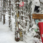
Connects: Aspen Mountain, Midway Road Ski Run Aspen, CO – Shrine The STRU Shrine is a memorial to Christian Daniel Streuli (STRU) who died on June 1, 2008. The shrine is located off Midway Road Ski Run on Aspen Mountain.…
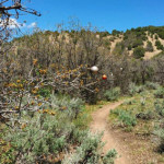
Connects: Prince Creek, The Crown, Monte Carlo Trail, Porcupine Trail News about the Christmas Tree Trail can be found at: The Aspen Times (December 23, 2017) – Grinch strips ornaments off Carbondale trail right before Christmas Prince Creek Printable Trail…
Connects: Transfer Trail Dotsero, CO – Medium – 29 Miles – Hike, Run, Mountain Bike, Dog Friendly – Dirt Coffee Pot Road (FSR #600) is an intermediate/moderate road you can hike, run, and mountain bike that is dog friendly. This…
Connects: Hagerman Pass Road (FSR #105), Douglass City, Opal Lake (11,390 ft), Hagerman Lake (11,330 ft), Hagerman Tunnel Leadville, CO – Easy – 5.5 Miles Roundtrip – Hike, Run, Horseback Ride, Dog Friendly – Dirt The Colorado Midland Trail, also…
Connects: Sunlight Mountain, Compass Trail Glenwood Springs, CO – Mountain Peak Compass Peak (9,895 ft) is the peak on Sunlight Mountain Resort. This is a mountain peak near Glenwood Springs, CO. View Larger Map
Connects: Aspen Mountain, Silver Queen Ski Run Aspen, CO – Mine Compromise Mine is an old silver mine on Aspen Mountain, above the Little Nell ski run, in Aspen, CO. The mine is not open to the public. News about…
Connects: Snowmass Bike Park, Ditch Trail, Government Trail Snowmass Village, CO – Medium – 1.1 Miles – Hike, Run, Mountain Bike, Dog Friendly – Dirt Connector Trail is an intermediate/moderate trail you can hike, run, and mountain bike that is…
Connects: Independence Pass Road (HWY 82), Independence Pass (12,095 ft), Independence Pass Scenic Trail Aspen, CO – Hard – Hike, Run, Horseback Ride, Dog Friendly – Dirt/Rocky The Continental Divide Trail is a difficult trail you can hike, run, and…
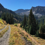
Connects: Castle Creek Road (CR 15), Silver Dollar Pond (10,245 ft), Conundrum Hot Springs (11,230 ft), Triangle Pass Trail, Triangle Pass (12,900 ft) Aspen, CO – Medium – 8.5 Miles – Hike, Run, Horseback Ride, Dog Friendly – Dirt/Rocky Conundrum…
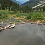
Connects: Conundrum Creek Trail Aspen, CO – Hot Springs The Conundrum Hot Springs (11,230 ft) is a natural hot springs along Conundrum Creek accessed by the Conundrum Creek Trail. This is a hot spring in the Maroon Bells-Snowmass Wilderness near…
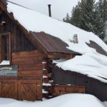
Connects: Castle Creek Road (CR 15), Montezuma Basin Road (FSR #102), Pearl Pass Road (FSR #102), Lindley Hut Distances: Bridge over Castle Creek to Lindley Hut – 1.8 Miles View Larger Map


