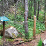
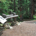
Connects: Independence Pass Road (HWY 82), Discovery Trail Aspen, CO – Easy – 0.2 Mile Loop – Hike, Dog Friendly – Dirt The Braille Trail is an easy trail you can hike that is dog friendly. This is a 0.2…

Connects: Independence Pass Road (HWY 82), Discovery Trail Aspen, CO – Easy – 0.2 Mile Loop – Hike, Dog Friendly – Dirt The Braille Trail is an easy trail you can hike that is dog friendly. This is a 0.2…
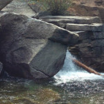
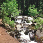
Connects: Grottos Trail, Ice Caves (Grottos) Aspen, CO – Waterfall The Cascades at the Grottos are a series of pools and waterfalls along black water-sculpted granite that flows down a section of the Roaring Fork River near Independence Pass. The…
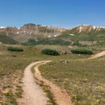
Connects: Independence Pass Road (HWY 82), Independence Pass (12,095 ft), Independence Pass Scenic Trail Aspen, CO – Hard – Hike, Run, Horseback Ride, Dog Friendly – Dirt/Rocky The Continental Divide Trail is a difficult trail you can hike, run, and…
Connects: Independence Pass Road (HWY 82), Difficult Campground, East of Aspen Trail
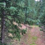
Connects: Independence Pass Road (HWY 82), Braille Trail Aspen, CO – Easy – 0.3 Mile Loop – Hike, Dog Friendly – Dirt The Discovery Trail is an easy trail you can hike that is dog friendly. This is a 0.3…
Connects: Independence Pass Road (HWY 82), Independence Ghost Town Aspen, CO – Hard – Hike, Run, Horseback Ride, Dog Friendly – Dirt Green Mountain Trail is a difficult trail you can hike, run, and horseback ride that is dog friendly.…
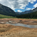
Connects: Lincoln Creek Road (FSR #106), Grizzly Lake Trail, Lincoln Portal Campground Aspen, CO – Reservior Grizzly Reservoir, officially called Lincoln Gulch Diversion Dam, is a 570 acre-foot reservoir near Aspen, CO that flows into Lincoln Creek and then the…
Connects: Independence Pass Road (HWY 82), Cascades, Ice Caves, Lincoln Gulch Campground View Larger Map
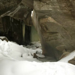
Connects: Grottos Trail, Cascades View Larger Map
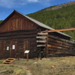
Connects: Independence Pass Road (HWY 82), Green Mountain Trail Aspen, CO – Ghost Town The Independence Ghost Town is a historic gold and silver mining town. At its’ peak in 1882 the Town of Independence had over 40 businesses, 3…
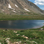
Connects: Lost Man Trail, Lost Man Pass (12,805 ft) Aspen, CO – Lake Independence Lake (12,497 ft) is an alpine lake accessed by the Lost Man Trail in the Hunter-Fryingpan Wilderness near Aspen, CO. More information about Independence Lake can…
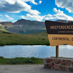
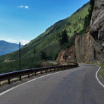
Connects: Independence Pass Road (HWY 82), Independence Pass Scenic Trail, Continental Divide Trail (Independence Pass) Aspen, CO – Mountain Pass Independence Pass (12,095 ft), originally called Hunter Pass, is a mountain pass along the Continental Divide accessed by Highway 82…
Connects: Anderson Park, Snyder Park Trail, East of Aspen Trail, North Star Nature Preserve, North Star Beach, Difficult Trail, Weller Lake Trail, Weller Campground, Devil’s Punchbowl, Grottos Trail, Lincoln Creek Road (FSR #106), Braille Trail, Discovery Trail, Lost Man Campground,…
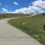
Connects: Independence Pass (12,095 ft), Independence Pass Road (HWY 82), Continental Divide Trail Aspen, CO – Easy – 0.5 Mile Loop – Walk, Dog Friendly – Paved The Independence Pass Scenic Trail is an easy trail you can walk that…
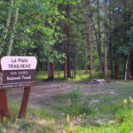
Connects: Independence Pass Road (HWY 82), Midway Trail, La Plata Peak (14,343 ft) Twin Lakes, CO – Hard – 4.3 Miles – Hike, Dog Friendly – Rocky/Dirt La Plata Gulch Trail, or La Plata Trail, is a difficult trail you…


