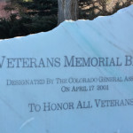
Connects: Carbondale, Roaring Fork River, Highway 82, Highway 133 (West Elk Loop Scenic Byway), Red Hill, Bob Terrell State Wildlife Area Carbondale, CO – Bridge Veterans Memorial Bridge is a bridge that spans the Roaring Fork River. This is a…

Connects: Carbondale, Roaring Fork River, Highway 82, Highway 133 (West Elk Loop Scenic Byway), Red Hill, Bob Terrell State Wildlife Area Carbondale, CO – Bridge Veterans Memorial Bridge is a bridge that spans the Roaring Fork River. This is a…
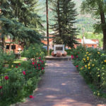
Connects: Main Street Aspen, CO – Park The Roaring Fork Valley Veterans Memorial Park, also simply called Veterans Park, is a park in downtown Aspen, CO. This park includes: Memorial Benches Picnic Tables News about Veterans Memorial Park can be…
Connects: Sky Mountain Park, Snowmass Loop, Highline Trail, Deadline Trail (Downhill Only), Skyline Ridge Trail Snowmass Village, CO – Medium – 1.6 Miles – Hike, Run, Mountain Bike – Dirt Viewline Trail is an intermediate/moderate difficulty trail you can hike,…
Connects: Snowmass Bike Park, Elk Camp Gondola, Government Trail Snowmass Village, CO – Easy – 2.7 Miles – Mountain Biking – Dirt Viking Trail, formerly Easy Rider Trail, is an easy mountain biking trail in Snowmass Village, CO. This is…
Connects: Snowmass Bike Park, Government Trail, Discovery Trail (Snowmass) Snowmass Village, CO – Easy – 2.3 Miles – Hike, Run, Mountain Bike, Dog Friendly – Dirt Village Bound Trail is an easy trail you can hike, run, and mountain bike…
Connects: Snowmass Ski Area, Snowmass Golf Course Trails (Winter) Snowmass Village, CO – Medium – 2 Miles – Classic XC Ski, Skate Ski, Dog Friendly – Snow Village Way Trail is an intermediate/moderate winter trail you can classic cross-country ski…
Connects: Tom Blake Trail, Powerline Trail, Government Trail, Verde Trail, Rabbit Run Trail, Elk Camp Resturant Snowmass Village, CO – Medium – 2.5 Miles – Hike, Run, Dog Friendly – Dirt Vista Trail is an intermediate/moderate difficulty trail you can…
Connects: VIX Ranch Park, Sunset Trail New Castle, CO – Bike Park VIX Ranch Bike Park, also called the New Castle Bike Park or New Castle Pump Track, is a dirt site at VIX Ranch Park in New Castle, CO.…
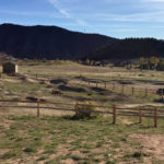
Connects: VIX Ranch Bike Park, Sunset Trail New Castle, CO – Park VIX Ranch Park is a large open area in New Castle, CO. This park includes: Open Area Benches Picnic Tables Baseball Field Soccer Field Restroom Bike Park View…
Connects: Glenwood Springs Elementary School Glenwood Springs, CO – 915 School Street Vogelaar Park in Glenwood Springs is a 4 acre park that includes a playground and a softball field. View Larger Map
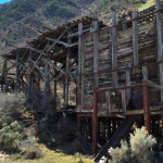
Connects: Colorado River, Coal Miner Memorial New Castle, CO – Historic Mine Vulcan Mine is an old coal mine on Burning Mountain in New Castle, CO. This is an old site. News about the Vulcan Mine can be found at:…
Connects: Marolt Trail, Midland Trail Aspen, CO – Easy – 0.2 Miles – Walk, Run, Road Bike, Dog Friendly – Paved W. Hopkins Trail is an easy trail you can walk, run, and bike that is dog friendly. This is…
Connects: Mill Street Mall Fountain Aspen, CO – Park Wagner Park is an open area, dog friendly park with watchful off-leash play in downtown Aspen, CO. This park includes: Restrooms Playground – also called Molar Park for the structure’s appearance…
Connects: Spring Gulch Trail System Carbondale, CO – Medium – 0.45 KM (0.28 Miles) – Classic XC Ski, Skate Ski – Snow Wagon Road Trail is an intermediate/moderate winter trail for cross-country skiing only. This is a 0.45 KM (0.28…
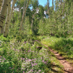
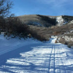
Glenwood Springs, CO – Medium – 4.6 Miles – Hike, Horseback Ride, Dog Friendly – Dirt Wagonwheel Trail #2049 is an intermediate/moderate trail you can hike and horseback ride that is dog friendly. This is a 4.6 mile dirt trail…


