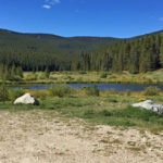
Connects: Norrie Road (FSR #504), Aspen/Norrie Trail, Spruce Creek Trail, Sawyer Lake Trail Norrie, CO – Campground Twin Meadows (9,465 ft) is a campground with two lakes accessed by Norrie Road (FSR #504) in Norrie, CO. View Larger Map

Connects: Norrie Road (FSR #504), Aspen/Norrie Trail, Spruce Creek Trail, Sawyer Lake Trail Norrie, CO – Campground Twin Meadows (9,465 ft) is a campground with two lakes accessed by Norrie Road (FSR #504) in Norrie, CO. View Larger Map
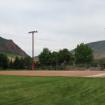
Connects: Rio Grande Trail, Glenwood Springs River Trail, Glenwood Skate Park, Storm King Firefighters Memorial Glenwood Springs, CO – Park Two Rivers Park in Glenwood Springs is a 22 acre park at the confluence of the Roaring Fork River and…
Connects: Aspen Mountain, Copper Bowl Aspen, CO – Memorial Uncle Wiggley’s Tree Farm is a section of Aspen Trees off Copper Bowl on Aspen Mountain in Aspen, CO. An engraved sign on an Aspen tree reads, “Howie Mayer AMSP from…
Connects: Capitol Creek Road (CR 9), Capitol Creek Trail View Larger Map
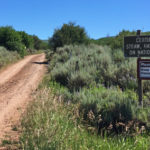
Connects: Basalt Mountain Road (FSR #524), Bowers Gulch Trail, Ditch Trail, Mill Creek Trail, North Fork Trail, Cattle Creek Trail Basalt, CO – Easy – 2.7 Miles – Hike, Run, Mountain Bike, Horseback Ride, Dog Friendly – Dirt Upper Cattle…
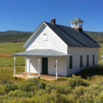
Connects: Coulter Creek Road (CR 121), Red Canyon Road (CR 115) Carbondale, CO – Schoolhouse The Upper Cattle Creek Schoolhouse, originally called Coulter Creek School, is a one-room schoolhouse that was used from 1888 to 1947. This is an old…
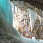
Connects: Koper’s Trail, Lower Ice Cave Rifle, CO – Ice Cave The Upper Ice Cave, inside the ice wall Old Tree Slab, is an open area of rock where ice covers the front to create an ice cave. This is…
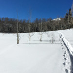
Connects: Sunlight Mountain, Sunlight Shelter, Babbish Trail, Dippsy Doodle Trail, Babbish Express Trail Glenwood Springs, CO – Easy – Snowshoe, Classic XC Ski, Dog Friendly – Snow The Upper Meadow Loop Trail is an easy winter trail you can snowshoe…
Snowmass Village, CO – Easy – Hike, Run, Mountain Bike, Horseback Ride, Dog Friendly – Dirt Upper North Mesa Equestrian Trail is an easy trail you can hike, run, mountain bike, and horseback ride that is dog friendly. This is…

The United States Forest Service and National Forest Foundation have an awesome campaign of videos showing the National Forests are truly all yours to explore, discover, enjoy and steward in every season. Tag your adventure with #ItsAllYours. It's All Yours…
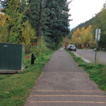
Connects: Glory Hole Park, Wheeler Ditch Trail, AJAX Park, Ute Mesa Trail, Ute Cemetery, Ute Park, Ute Trail, The Aspen Club & Spa, East of Aspen Trail Aspen, CO – Easy – 2.5 Miles – Walk, Run, Road Bike, Dog…
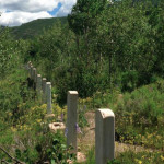
Connects: Ute Avenue Trail, Wheeler Ditch Trail, Ute Park, Ute Trail Aspen, CO – Cemetery Ute Cemetery is a historic cemetery established in 1880 in Aspen, CO. The Ute Cemetery is listed on the National Register of Historic Places. More…
Connects: Ute Avenue Trail, AJAX Park, AJAX Trail, Ute Trail Aspen, CO – Medium – 0.2 Miles – Hike, Run, Dog Friendly – Dirt Ute Mesa Trail is an intermediate/moderate connector trail you can hike and run that is is…
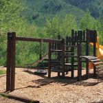
Connects: Ute Avenue Trail, Ute Trail, Ute Cemetery, Wheeler Ditch Trail Aspen, CO – Park Ute Park is a park in an an area surrounded by Aspen trees above the Roaring Fork River in Aspen, CO. This park includes: Playground…
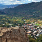
Connects: Ute Trail Aspen, CO – Viewing Area The Ute Rock Overlook (9,050 ft) is a rocky outcrop on Aspen Mountain that has a scenic overlook of the town. This is a site 0.9 miles up the Ute Trail in…


