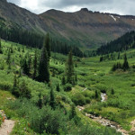
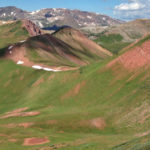
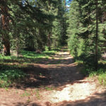
Connects: Lincoln Creek Road (FSR #106), Grizzly Reservoir, Grizzly Lake (12,500 ft) Aspen, CO – Medium – 3.6 Miles – Hike, Run, Horseback Ride, Dog Friendly – Rocky/Dirt Grizzly Lake Trail #1990 is an intermediate/moderate trail you can hike, run,…

Connects: Lincoln Creek Road (FSR #106), Grizzly Reservoir, Grizzly Lake (12,500 ft) Aspen, CO – Medium – 3.6 Miles – Hike, Run, Horseback Ride, Dog Friendly – Rocky/Dirt Grizzly Lake Trail #1990 is an intermediate/moderate trail you can hike, run,…
Connects: Independence Pass Road (HWY 82), Cascades, Ice Caves, Lincoln Gulch Campground View Larger Map
Connects: Frying Pan Road (CR 104), Sellar Meadow (9,630 ft), Sellar Coke Ovens, Forest Service Road #502, Hell Gate, Ivanhoe Lake Road (FSR #527), Lyle/Mormon Lake Trail, Ivanhoe Lake Road (FSR #527), Busk-Ivanhoe Tunnel, Lyle/Mormon Lakes Trail, Hagerman Pass (11,925…
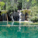
Connects: Glenwood Canyon, Hanging Lake Rest Area, Glenwood Canyon Trail, Dead Horse Creek, Dead Horse Trail, Hanging Lake (7,175 ft), Spouting Rock (7,323 ft) View Larger Map
Connects: Four Pass Loop, West Maroon Trail, Hasley Pass (12,144 ft), Fravert Basin Trail Aspen, CO – Hard – 4.2 Miles – Hike, Run, Horseback Ride, Dog Friendly – Rocky/Dirt Hasley Basin Trail is a difficult trail you can hike,…
Connects: Rio Grande Trail, Lani White Trail, Benedict Bridge, Verena Mallory Trail, Emilee Benedict Park, Hunter Creek Cutoff Trail, Hunter Valley Trail, Red Mountain Road, Van Horn Park (9,900 ft), Slab Park, Woody Creek Trail, Midway Creek Trail Smuggler Mountain…
Connects: Highway 133 (West Elk Loop Scenic Byway), McClure Pass (8,755 ft) Marble, CO – Hard – Hike, Run, Mountain Bike, Horseback Ride, Dog Friendly – Rocky/Dirt Huntsman Ridge Road (FSR #517), also called Huntsman Ridge Trail, is a difficult…
Connects: Arbaney Traverse, Arbaney Kittle Trail, Red Canyon Trail, Old Colorado Mountain Club Cabin, Forest Service Road #513, Kobey Park Road (FSR #508) Lenado, CO – Hard – 3 Miles – Hike, Run, Mountain Bike, Horseback Ride, Dog Friendly –…
Connects: Rifle Creek Road (CR 217), Lower Ice Cave, Old Tree Slab (Winter), Upper Ice Cave, Full Metal Jacket (Winter), The Final Curtain (Winter) View Larger Map
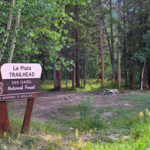
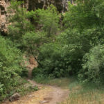
Connects: Independence Pass Road (HWY 82), Midway Trail, La Plata Peak (14,343 ft) Twin Lakes, CO – Hard – 4.3 Miles – Hike, Dog Friendly – Rocky/Dirt La Plata Gulch Trail, or La Plata Trail, is a difficult trail you…
Connects: Gunnison County Road 3, Daniels Hill, Lead King Loop, North Lost Trail, Silver Creek Trail, Schofield Pass Road (FSR #317), Crystal City Road (FSR #314), Avalanche Pass Trail Marble, CO – Hard – Hike, Run, Mountain Bike, Horseback Ride,…
Connects: Lizard Lake, Crystal City Road (FSR #314) Marble, CO – Hard – 0.30 Miles – Hike – Rocky/Dirt The Legend of Tall Tree Trail is a difficult unmarked trail you can hike. This is a short tough climb up…
Connects: Arbaney Traverse, Four Corners (9,785 ft), Red Mountain Road (FSR 130.3), Secret Trail (Sunnyside Trail), Four Corners Road (20B.1), Van Horn Trail, Hobbit Trail, Lenado Aspen, Lenado, CO – Medium – 2.5 Miles – Hike, Run, Mountain Bike, Horseback…
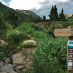
Connects: Independence Pass Road (HWY 82), Lincoln Gulch Campground, Lincoln Creek Grottos, New York Creek Trail, Tabor Creek Trail, Grizzly Reservoir, Grizzly Lake Trail, Lincoln Portal Campground, Truro Lake Trail, Petroleum & Anderson Lake Trail, Ruby Ghost Town Aspen, CO…
Connects: Independence Pass Road (HWY 82), Lost Man Trail, Linkins Lake (12,008 ft) Aspen, CO – Hard – 0.6 Miles – Hike, Run, Horseback Ride, Dog Friendly – Dirt Linkins Lake Trail #1979 is a difficult trail you can hike,…


