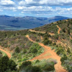
Connects: Taylor Pass (11,930 ft), Express Creek Road (FSR #122), Richmond Hill Road (FSR #123) Ashcroft, CO – Lake Taylor Lake (11,550 ft) is an alpine lake below Taylor Pass (11,930 ft) near Ashcroft accessed by Express Creek Road (FSR…

Taylor Pass (11,930 ft)
Connects: Express Creek Road (FSR #122), Richmond Hill Road (FSR #123), Taylor Lake (11,550 ft) Ashcroft, CO – Mountain Pass Taylor Pass (11,930 ft) is a mountain pass near Ashcroft accessed by Express Creek Road (FSR #122) and Richmond Hill…
Tellurium Lake (10,570 ft)
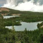
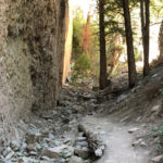
Connects: Tellurium Lake Trail Thomasville, CO – Lake Tellurium Lake (10,570 ft) is an alpine lake in the Holy Cross Wilderness accessed by the Tellurium Lake Trail. This is a lake near Thomasville, CO. More information about Tellurium Lake Trail…
Tellurium Lake Trail
Connects: Burnt Mountain Road (FSR #506), Woods Lake Trail, Tellurium Lake (10,570 ft), Last Chance Trail, Josephine Lake Trail, Coffeepot Park (10,550 ft), Henderson Park (10,390 ft), Henderson Park Trail Thomasville, CO – Medium – 6.8 Miles – Hike, Run,…
Posted in 4-7 Miles, 7 Miles, Basalt, Dirt, Dog Friendly, Hiking, Holy Cross Wilderness, Horseback Riding, Medium, Meredith, Moderate, Running, Trails
Tenderfoot Trail
Connects: Sunlight Mountain, Chair Lift 2, Holiday Hill Trail, Old Four Mile Road Glenwood Springs, CO – Easy – Snowshoe, Classic XC Ski, Dog Friendly – Snow Tenderfoot Trail is an easy winter trail you can snowshoe and classic cross-country…
Terminator Trail (Winter)
Connects: Tom Blake Equestrian Trail, Owl Creek Trail, Hahnenkamm Downhill, Anaerobic Nightmare Trail Snowmass Village, CO – Hard – 2 Miles – Snowshoe, Classic XC Ski, Skate Ski – Snow The Terminator Trail is a difficult winter trail you can…
Terral Wade Bridge (Tiehack Nordic Bridge)
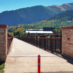
Connects: Maroon Creek Road (CR 13), Aspen Recreation Center, Moore Trail, Iselin/Rotary Trail, Iselin Park, Whoa Nelly Sledding Hill (Winter), Maroon Creek Trail, Government Trail, Aspen Fat Bike Loop, Tiehack Trail, Tiehack Summer Road, Tiehack Uphill Route (Winter) Aspen, CO…
Posted in Aspen, Bridge, Sites Tagged with: Tiehack Bridge, Tiehack Nordic Bridge, Tiehack Pedestrian Bridge
The Crown
Connects: BLM Road 8320, BLM Road 8321, BLM Road 8322, BLM Road 8323, BLM Road 8324, BLM Road 8325, Buckhorn Trail, Buckhorn Traverse, Christmas Tree Trail, Father of Ginormous Trail (Downhill Only), Glassier Trail, Glassier (Bike/Hike) Trail, Glassier (Horse/Hike) Trail,…
Posted in Basalt, Carbondale, Prince Creek Trail System, Recreation Area, Sites, The Crown Tagged with: Crown Trails, The Crown Trails
The Narrows Trail
Connects: Highway 133 (West Elk Loop Scenic Byway), Penny Hot Springs, The Narrows Carbondale, CO – Hard – Hike – Rocky The Narrows Trail is a difficult trail you can hike that leads to the climbing area known as The…
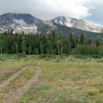
Thomas Lakes (10,200 ft)
Connects: Thomas Lakes Trail, Mount Sopris Trail Basalt, Carbondale, CO – Lakes Thomas Lakes (10,200 ft) are three separate lakes in the Maroon Bells-Snowmass Wilderness found along the Thomas Lakes Trail, at the base of Mount Sopris and the Mount…
Thomas Lakes Trail
Connects: Dinkle Lake Road, Mount Sopris Trail, Hay Park Trail, Thomas Lakes (10,200 ft) Basalt, Carbondale, CO – Medium – 3.6 Miles – Hike, Run, Mountain Bike, Dog Friendly – Dirt Thomas Lakes Trail #1958 is an intermediate/moderate trail you…
Posted in 4 Miles, 4-7 Miles, Basalt, Carbondale, Dog Friendly, Hiking, Maroon Bells-Snowmass Wilderness, Medium, Moderate, Mountain Biking, Running, Trails
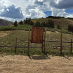
Thomasville Lime Kilns
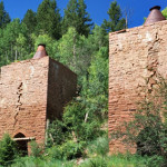
Connects: Frying Pan Road (CR 104) Thomasville, CO – Lime Kilns The Thomasville Lime Kilns were built in 1888 and are some of the largest in existence. This is a site near Reudi Reservoir in Thomasville, CO. View Larger Map
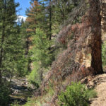
Thompson Creek Climbing Area
Connects: Thompson Creek Trail Carbondale, CO – Climbing The Thompson Creek Climbing Area is a section of rock with routes for climbing near Carbondale, CO. Thompson Creek is an Area of Critical Environmental Concern (ACEC). This area is currently access…
Thompson Creek Road (CR 108)
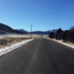
Connects: Tick Ridge, Hardwick Bridge Road (CR 109), Dry Park Road (CR 125), Lorax Trail, Marion Cemetery, Marion Gulch Trail, Spring Gulch, Jerome Park, South Thompson Creek Road (FSR #305) Carbondale, CO – Medium – Road Bike – Paved Thompson…
Posted in 8-10+ Miles, Carbondale, Medium, Moderate, More Than 10 Miles, Paved, Road Biking, Trails Tagged with: Sweet Hill
Thompson Creek Trail
Connects: South Thompson Creek Road (FSR #305), Thompson Creek Climbing Area More information about Thompson Creek Trail can be found at: Bureau of Land Management (BLM) – Thompson Creek Extensive Recreation Management Area Map View Larger Map


