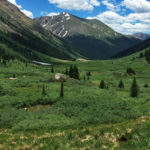
Connects: Independence Pass Road (HWY 82), Blue Lake Trail, Fryingpan Pass (12,438 ft) Aspen, CO – Medium – 4 Miles – Hike, Run, Horseback Ride, Dog Friendly – Dirt North Fork Trail, also called North Fork Lake Creek Trail, is…

Connects: Independence Pass Road (HWY 82), Blue Lake Trail, Fryingpan Pass (12,438 ft) Aspen, CO – Medium – 4 Miles – Hike, Run, Horseback Ride, Dog Friendly – Dirt North Fork Trail, also called North Fork Lake Creek Trail, is…
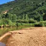
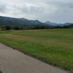
Connects: Independence Pass Road (HWY 82), North Star Nature Preserve, Ranch Gate Trail, East of Aspen Trail Aspen, CO – Beach The North Star Beach is a sandy beach area along the Roaring Fork River in the North Star Nature…
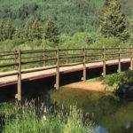
Connects: Roaring Fork River, North Star Nature Preserve, Independence Pass Road (HWY 82), East of Aspen Trail Aspen, CO – Bridge The North Star Bridge, or simply called the Take Out Bridge, is a pedestrian bridge over the Roaring Fork…
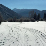
Connects: East of Aspen Trail, North Star Nature Preserve, Benedict Trail (Winter) Aspen, CO – Easy – 2.57 KM (1.6 Miles) – Snowshoe, Classic XC Ski, Skate Ski – Snow The North Star Loop is an easy groomed loop you…
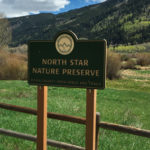
Connects: Independence Pass Road (HWY 82), East of Aspen Trail, North Star Bridge, North Bridge Trail, Viewing Platform, Ranch Gate Trail, North Star Beach, South Trail, James H. Smith North Star Open Space, North Star Loop (Winter) Aspen, CO –…
Connects: Rio Grande Trail, Newbury Park, Fox Crossing Park Aspen, CO – Easy – 0.16 Miles – Walk, Run, Road Bike, Dog Friendly – Paved Oklahoma Flats Trail is an easy trail you can walk, run, and bike that is…
Connects: ABC Trail, Burlingame Trail View Larger Map View Larger Map
Connects: Government Trail, Tiehack Trail, Tiehack Summer Road, Buttermilk Summer Road, Buttermilk Trail Aspen, CO – Medium – Hike, Run, Mountain Bike, Dog Friendly – Dirt The Oregon Trail is an intermediate/moderate trail you can hike, run, and mountain bike…
Connects: Tiehack Warming Hut, Maroon Creek Club Trail (Winter), ABC Trail, Owl Creek Road (CR 12), Buttermilk Connector Trail, Airline Trail, Highline Trail, Sinclair Meadows Trail, Terminator Trail (Winter), Tom Blake Trail, Tom Blake Equestrian Trail, Snowmass Golf Course Trails…
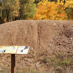
Connects: Smuggler Mountain, Behind The Sign (BTS) Trail Aspen, CO – Mine Park Regent Mine is an abandon mine site on Smuggler Mountain. This is a historic site in Aspen, CO. Smuggler Mountain Printable Trail Map View Larger Map
Connects: Aspen Mountain, Back of Bell #1 Ski Run Aspen, CO – Shrine The Patti Seifert Shrine, or Patti’s Paradise, is a memorial to the Aspen schoolteacher who died of cancer on July 27, 2008. The shrine is located off…

Connects: Buckhorn Ski Run, Buckhorn Warming Hut, Westside Trail, Cherry Trail, Hidden Treasure Trail Aspen, CO – Viewing Area Peanut Butter Ridge is a spot on Aspen Mountain at the bottom of the Buckhorn Ski Run that overlooks the Castle…
Connects: Aspen to Crested Butte, Pearl Pass Road (FSR #102) Aspen, Crested Butte, CO – Mountain Pass Pearl Pass (12,705 ft) is a mountain pass in the Elk Mountains along Pearl Pass Road that can be used to connect Aspen…
Connects: Castle Creek, Montezuma Basin Road (FSR #102) Ashcroft, CO – Bridge Pearl Pass Bridge is a small bridge over Castle Creek along Montezuma Basin Road (FSR #102) near Ashcroft, CO. More information about Montezuma Basin Road (FSR #102) can…
Connects: Aspen to Crested Butte, Montezuma Basin Road (FSR #102), Tagert Hut, Green-Wilson Hut, Pearl Pass Ashcroft, CO – Hard – Hike, Run, Mountain Bike, Horseback Ride, Dog Friendly – Rocky/Dirt Pearl Pass Road (FSR #102) is a difficult road…


