Snowmass Lake (10,980 ft)

Snowmass Lake

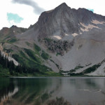
Connects: Four Pass Loop, Three Pass Loop, Aspen to Marble, Maroon-Snowmass Trail, Geneva Lake Trail Snowmass, CO – Lake Snowmass Lake (10,980 ft) is an alpine lake in the Maroon Bells-Snowmass Wilderness accessed at the junction of the Maroon-Snowmass Trail

Posted in Lake, Maroon Bells-Snowmass Wilderness, Sites, Snowmass Mountain, Snowmass Village, Water

Snowmass Loop

Snowmass Loop

Connects: Snowmass Recreation Center, Rodeo Park, Snowmass Skate Park, Brush Creek Trail, Sky Mountain Park, Ditchline Trail, Viewline Trail, Deadline Trail (Downhill Only), Highline Trail, Tom Blake Trail, Anaerobic Nightmare Trail, Powerline Trail, Verde Trail, Government Trail, Cross Mountain Trail

Posted in 8-10+ Miles, Difficult, Dirt, Hard, Hiking, Large Loops/Backpacking, More Than 10 Miles, Mountain Biking, Running, Snowmass Ski Area, Snowmass Village, Trails

Snowmass Peak (13,627 ft)

Snowmass Lake

Connects: Maroon Bells-Snowmass Wilderness Snowmass, CO – Mountain Peak Snowmass Peak (13,627 ft) is a peak in the Maroon Bells-Snowmass Wilderness of the White River National Forest near Snowmass, CO. More information about Snowmass Peak can be found at: Wikipedia

Posted in Aspen, Maroon Bells-Snowmass Wilderness, Mountain Peak, Old Snowmass, Rock, Sites, Snowmass Village

South Branch Trail

South Branch Trail

Connects: Middle Thompson Creek Road (FSR #306), Dexter Park Trail Carbondale, CO – Medium – 6 Miles – Hike, Run, Mountain Bike, Horseback Ride, Dog Friendly – Dirt South Branch Trail #1951 is an intermediate/moderate trail you can hike, run,

Posted in 4-7 Miles, 6 Miles, Carbondale, Dirt, Dog Friendly, Hiking, Horseback Riding, Medium, Moderate, Mountain Biking, Running, Thompson Divide, Trails

South Canyon

Connects: Lower Valley Trail (LoVa Trail), South Canyon Creek Road (CR 134), South Canyon Bridge, South Canyon Archery Range, Tramway Trail, South Canyon Hot Springs, South Canyon Landfill Glenwood Springs, CO – Difficult Varies – Hike, Run, Mountain Bike, Dog

Posted in 1-3 Miles, 4-7 Miles, 8-10+ Miles, Dirt, Dog Friendly, Easy, Glenwood Springs, Hard, Hiking, Horseback Riding, Medium, Moderate, Mountain Biking, Paved, Road Biking, Running, South Canyon, Trails

South Canyon Archery Range

South Canyon Archery Range

Connects: South Canyon, South Canyon Creek Road (CR 134), South Canyon Bridge, Lower Valley Trail (LoVa Trail) Glenwood Springs, CO – Archery Range South Canyon Archery Range is a bow and arrow shooting range in the South Canyon west of

Posted in Glenwood Springs, Shooting/Archery Range, Sites, South Canyon

South Canyon Bridge

South Canõn Bridge

Connects: Lower Valley Trail (LoVa Trail), South Canyon, Colorado River, South Canyon Creek Road (CR 134), South Canyon Archery Range Glenwood Springs, CO – Bridge South Canyon Bridge, originally spelled South Canõn Bridge, is a historic bridge built in 1915

Posted in Bridge, Glenwood Springs, Historic, Sites, South Canyon Tagged with: ,

South Canyon Creek Road (CR 134)

South Canyon Creek Road

Connects: Lower Valley Trail (LoVa Trail), South Canyon, South Canyon Bridge, South Canyon Archery Range, Tramway Trail, South Canyon Hot Springs, South Canyon Landfill, South Canyon Sledding Hill (Winter) Glenwood Springs, CO – Medium – Road Bike, Mountain Bike –

Posted in Dirt, Glenwood Springs, Medium, Moderate, Mountain Biking, Paved, Road Biking, South Canyon, Trails

South Canyon Hot Springs

South Canyon Hot Springs

Connects: South Canyon, South Canyon Creek Road (CR 134) Glenwood Springs, CO – Hot Springs The South Canyon Hot Springs, also known as Hippy Hot Springs, are a natural hot spring just west of Glenwood Springs in the South Canyon.

Posted in Glenwood Springs, Hot Springs, Sites, South Canyon Tagged with: ,

South Fork Fryingpan Trail

South Fork Fryingpan Trail

Connects: Nast Lake Trail, Nast Lake (8,700 ft), Granite Lakes Trail, Chapman Lake (9,785 ft) Meredith, CO – Medium – 1 Mile – Hike, Run, Dog Friendly – Dirt South Fork Fryingpan Trail #1924 is an intermediate/moderate trail you can

Posted in 1 Mile, 1-3 Miles, Basalt, Dirt, Dog Friendly, Hiking, Hunter-Fryingpan Wilderness, Medium, Meredith, Moderate, Norrie, Ruedi Reservoir, Running, Trails Tagged with: ,

South Fork Pass (11,730 ft)

Connects: South Fork Pass Trail Aspen, CO – Mountain Pass South Fork Pass (11,730 ft) is a mountain pass in the Hunter-Fryingpan Wilderness accessed along the South Fork Pass Trail. More information about South Fork Pass Trail can be found

Posted in Hunter-Fryingpan Wilderness, Independence Pass, Mountain Pass, Norrie, Sites

South Fork Pass Trail

South Fork Pass Trail

Connects: Norrie Road (FSR #504), Deadman Lake (10,965 ft), South Fork Pass (11,730 ft), Lost Man Trail Norrie Colony, Aspen, CO – Medium – 4.5 Miles – Hike, Run, Horseback Ride, Dog Friendly – Dirt South Fork Pass Trail #1940

Posted in 4 Miles, 4-7 Miles, Basalt, Dirt, Dog Friendly, Hiking, Horseback Riding, Hunter-Fryingpan Wilderness, Independence Pass, Medium, Meredith, Moderate, Ruedi Reservoir, Running, Trails

South Thompson Trail

Connects: South Thompson Creek Road (FSR #305), Parsnip Flat Road, Braderich Creek Trail Carbondale, CO – Medium – 3.4 Miles – Hike, Run, Mountain Bike, Horseback Ride, Dog Friendly – Dirt South Thompson Trail #1952 is an intermediate/moderate trail you

Posted in 1-3 Miles, 3 Miles, Carbondale, Dirt, Dog Friendly, Hiking, Horseback Riding, Medium, Moderate, Mountain Biking, Running, Thompson Divide, Trails Tagged with: ,

Spruce Creek Trail

Connects: Woody Creek Trail, Aspen/Norrie Trail, Sawmill Park, Mt. Yeckel (11,765 ft), Twin Meadows Woody Creek, CO – Medium – 8 Miles – Hike, Run, Horseback Ride, Dog Friendly – Dirt Spruce Creek Trail #1927 is an intermediate/moderate trail you

Posted in 8 Miles, 8-10+ Miles, Aspen, Dirt, Dog Friendly, Hiking, Horseback Riding, Hunter-Fryingpan Wilderness, Lenado, Medium, Moderate, Running, Trails, Woody Creek

Squirrel Trail

Squirrel Trail

Connects: Rifle Falls State Park, Coyote Trail More information about the Rifle Falls State Park can be found at: Colorado Parks & Wildlife – Rifle Falls Trails Squirrel Trail Map Rifle Falls State Park View Larger Map

Posted in 1-3 Miles, 2 Miles, Dirt, Dog Friendly, Easy, Hiking, Rifle, Rifle Falls State Park, Running, Trails

Trail Search

Find a trail. Use 1 or all 4 drop downs to customize your search for the right trail.

Dog Friendly:

  or  

Park Search

Find a park. Use the drop downs to find the perfect park.

Dog Friendly:

  or  

Featured and Mentioned On

Questions? Email us at info@aspentrailfinder.com
By using this site you agree to the terms of our User Agreement. Read our Disclaimer.