
Carbondale History Quiz
How much do you know about Carbondale’s history?
Carbondale Skate Park
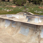
Connects: The North Face Park, North Face Bike Park Carbondale, CO – Skate Park The Carbondale Skate Park, also called North Face Sk8 Park, is a concrete area with skating obstacles in Carbondale, CO. This park includes: Skate Park Elements…
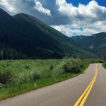
Carbondale to Crested Butte
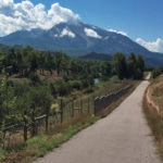
Connects: Highway 133 (West Elk Loop Scenic Byway), Crystal Valley Trail, Redstone (7,200 ft), Marble (8,000 ft), McClure Pass (8,755 ft), Kebler Pass (10,007 ft) Carbondale, CO – Hard – 74 Miles – Hike, Run, Mountain Bike, Horseback Ride, Dog…
Posted in 8-10+ Miles, Carbondale, Crested Butte, Difficult, Dirt, Dog Friendly, Hard, Hiking, Horseback Riding, Large Loops/Backpacking, More Than 10 Miles, Mountain Biking, Paved, Road Biking, Running, Trails Tagged with: C to CB, C to CB Trail, C-CBT, Carbondale to Crested Butte Trail, Crystal Trail
Cardiff Coke Ovens
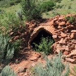
Connects: Cardiff Trail Glenwood Springs, CO – Coke Ovens The Cardiff Coke Ovens are a series of coke ovens in Glenwood Springs, CO. These coke ovens are listed on the National Register of Historic Places. More information about the Cardiff…
Cardiff Glen Park
Glenwood Springs, CO – Park Cardiff Glen Park is an open area in the Cardiff Glen subdivision in Glenwood Springs, CO. This park includes: Playground 1 Infant Swing 1 Child Swing Open Area Picnic Table Dogs are not allowed. View…
Cardiff Schoolhouse
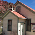
Connects: Conservancy Park, Park East Community Trail Glenwood Springs, CO – Historic Building The Cardiff Schoolhouse is an old schoolhouse in Glenwood Springs, CO. This is a site in the Park East neighborhood at Conservancy Park. A plaque on the…
Posted in Glenwood Springs Parks, Historic, Sites Tagged with: Cardiff School, Cardiff School House, Cardiff Schoolhouse Museum
Cardiff Trail
Connects: Cardiff Coke Ovens Glenwood Springs, CO – Medium – Hike, Run, Mountain Bike, Dog Friendly – Dirt The Cardiff Trail is an intermediate/moderate trail you can hike, run and mountain bike that is dog friendly. This is a dirt…
Posted in Dirt, Dog Friendly, Glenwood Springs, Hiking, Historic, Medium, Moderate, Mountain Biking, Running, Trails Tagged with: Beehive Ovens
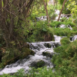
Cascades (Grottos)
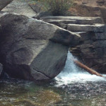
Connects: Grottos Trail, Ice Caves (Grottos) Aspen, CO – Waterfall The Cascades at the Grottos are a series of pools and waterfalls along black water-sculpted granite that flows down a section of the Roaring Fork River near Independence Pass. The…
Cascades (Rifle)
Connects: Rifle Falls State Park, Bobcat Trail Rifle, CO – Waterfall The Rifle Cascades (6,820 ft) are a series of rocks with flowing water on East Rifle Creek at the Rifle Falls Fish Hatchery near Rifle Falls State Park. This…
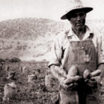
Case for the ROFO Fund
Earlier this year, we created the ROFO Fund. “The what the what fund?” you ask. We’ll explain. We wanted a way to get people involved and give back to the Roaring Fork Valley, these outdoors. The ROFO Fund was created…
Castle Creek Road (CR 15)
Connects: Marolt Trail, Castle Creek Trail (Proposed), Congo Trail, Midnight Mine Road (FSR #118), Conundrum Creek Trail, Little Annie Road (CR 15G), American Lake Trail, Express Creek Road (FSR #122), Ashcroft Ghost Town, River Run Trail, King Cabin, Ashcroft Ski…
Posted in 8-10+ Miles, Ashcroft, Ashcroft Ski Touring System, Aspen, Classic XC Skiing, Dog Friendly, Easy, Medium, Moderate, More Than 10 Miles, Nordic (XC Ski), Paved, Road Biking, Skate Skiing, Snow, Snowshoeing, Trails Tagged with: Best Fall Colors, County Road, Leaf Peeping
Castle Creek Trail (Proposed)
Connects: Marolt Trail, Castle Creek Road (CR 15), Aspen Country Day School, Aspen Music Festival and School Aspen, CO – Easy – 0.6 Miles – Walk, Run, Bike, Dog Friendly The Castle Creek Trail is a proposed trail to parallel…
Posted in 1 Mile, 1-3 Miles, Aspen, Dog Friendly, Easy, Less Than A Mile, Paved, Road Biking, Running, Trails, Walking
Castle/Conundrum Peak Trail
Connects: Montezuma Basin Road (FSR #102), Castle Peak (14,279 ft), Conundrum Peak (14,040 ft) Ashcroft, CO – Hard – Hike -Rocky The Castle/Conundrum Peak Trail is a difficult trail you can hike to Castle Peak (14,279 ft) and Conundrum Peak…
Cathedral Lake (11,865 ft)
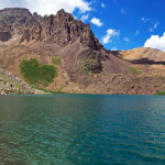
Connects: Cathedral Lake Trail, Electric Pass Trail Aspen, CO – Lake Cathedral Lake (11,865 ft) is an alpine lake at the base of Cathedral Peak in the Maroon Bells-Snowmass Wilderness accessed by the Cathedral Lake Trail that flows into Pine…


