Connects: Smuggler Mountain, Smuggler Mountain Road (FSR #131), Lollipop Trail, Behind The Sign (BTS) Trail, Iowa Shaft Mine, Hunter Creek Cutoff Trail Aspen, CO – Medium – 0.40 Miles – Hike, Run, Mountain Bike, Dog Friendly – Dirt 10th Mountain…

Connects: Smuggler Mountain, Smuggler Mountain Road (FSR #131), Lollipop Trail, Behind The Sign (BTS) Trail, Iowa Shaft Mine, Hunter Creek Cutoff Trail Aspen, CO – Medium – 0.40 Miles – Hike, Run, Mountain Bike, Dog Friendly – Dirt 10th Mountain…
Connects: Castle Creek Road (CR 15), American Lake (11,365 ft) View Larger Map
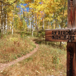
Connects: Snowmass Loop, Tom Blake Trail, Tom Blake Equestrian Trail, Terminator Trail (Winter), Government Trail Snowmass Village, CO – Hard – 0.6 Miles – Hike, Run, Mountain Bike, Dog Friendly – Dirt Anaerobic Nightmare Trail is a difficult trail you…
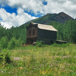
Connects: Castle Creek Road (CR 15), Express Creek Road (FSR #122), River Run Trail, Ashcroft Ski Touring Trails (Winter) Aspen, CO – Ghost Town The Ashcroft Ghost Town is a site 11 miles up Castle Creek Road near Aspen, CO.…
Connects: Upper Cattle Creek Road (FSR #509), Ditch Trail (Basalt Mountain), Road #3524, Mill Creek Trail, Basalt Mountain Trail Basalt, CO – Medium – 9 Miles – Hike, Run, Mountain Bike, Horseback Ride, Dog Friendly – Dirt Basalt Mountain Road…
Connects: Snowmass Creek Road (CR 11), East Sopris Creek Road (CR 7), Monastery Road (CR 9B), St. Benedict’s Monastery, Nickelson Creek Road (CR 9D), Hay Park Trail, Capitol Creek Trail, Upper Capitol Creek Trail, Hell Roaring Trail
Connects: Capitol Creek Road (CR 9), Nickelson Creek Trail, Upper Capitol Creek Trail, Avalanche Creek Trail, West Snowmass Trail, Capitol Lake (11,600 ft) View Larger Map
Connects: Marolt Trail, Castle Creek Trail (Proposed), Congo Trail, Midnight Mine Road (FSR #118), Conundrum Creek Trail, Little Annie Road (CR 15G), American Lake Trail, Express Creek Road (FSR #122), Ashcroft Ghost Town, River Run Trail, King Cabin, Ashcroft Ski…
Connects: Castle Creek Road (CR 15), Cathedral Lake (11,866 ft), Electric Pass Trail Aspen, CO – Hard – 2.8 Miles – Hike, Run, Horseback Ride, Dog Friendly – Dirt Cathedral Lake Trail #1984 is a difficult trail you can hike,…
Connects: Castle Creek Road (CR 15), Highlands Summer Road Aspen, CO – Hard – 1.7 Miles – Hike, Run, Mountain Bike, Dog Friendly – Dirt Congo Trail is a difficult trail you can hike, run, and mountain bike that is…
Connects: Castle Creek Road (CR 15), Silver Dollar Pond (10,245 ft), Conundrum Hot Springs (11,230 ft), Triangle Pass Trail, Triangle Pass (12,900 ft) Aspen, CO – Medium – 8.5 Miles – Hike, Run, Horseback Ride, Dog Friendly – Dirt/Rocky Conundrum…
Connects: Castle Creek Road (CR 15), Montezuma Basin Road (FSR #102), Pearl Pass Road (FSR #102), Lindley Hut Distances: Bridge over Castle Creek to Lindley Hut – 1.8 Miles View Larger Map
Connects: Maroon Lake (9,585 ft), Maroon Bells Scenic Trail, West Maroon Portal Trail, Four Pass Loop, Maroon-Snowmass Trail, West Maroon Trail, Crater Lake (10,076 ft) Aspen, CO – Medium – 1.8 Miles – Hike, Run, Dog Friendly – Rocky/Dirt Crater…
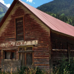
Connects: Lead King Loop, Crystal City Road (FSR #314), Crystal Mill Marble, CO – Ghost Town Crystal City, also called the Town of Crystal and Crystal Ghost Town, is an old town on the Lead King Loop accessed along Crystal…
Connects: Gunnison County Road 3, Daniels Hill, Lead King Loop, Schofield Pass Road (FSR #317), Lead King Basin Road (FSR #315), Lizard Lake, Legend of Tall Tree Trail, Crystal Mill, Crystal City (Town of Crystal) Marble, CO – Medium –…


