Connects: Linkins Lake Trail Aspen, CO – Lake Linkins Lake (12,008 ft) is an alpine lake accessed by the Linkins Lake Trail in the Hunter-Fryingpan Wilderness near Aspen, CO. More information about Linkins Lake is available at: White River National…

Connects: Linkins Lake Trail Aspen, CO – Lake Linkins Lake (12,008 ft) is an alpine lake accessed by the Linkins Lake Trail in the Hunter-Fryingpan Wilderness near Aspen, CO. More information about Linkins Lake is available at: White River National…
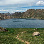
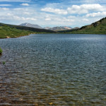
Connects: Lost Man Trail, Lost Man Pass (12,805 ft) Aspen, CO – Lake Lost Man Lake (12,450 ft) is an alpine lake in the Hunter-Fryingpan Wilderness accessed by the Lost Man Trail. More information about Lost Man Lake can be…
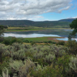
Connects: Lost Man Trail, Midway Creek Trail Aspen, CO – Reservoir Lost Man Reservoir (10,580 ft) is a 30- to 40-acre-foot earthen-bottom reservoir on Lost Man Creek near Independence Pass in Aspen, CO. Lost Man Reservoir is accessed along the…
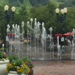
Connects: Wagner Park Aspen, CO – Fountain The Mill Street Mall Fountain, or simply the Aspen Fountain, is a water feature on Mill Street in Aspen, CO. View Larger Map
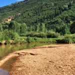
Connects: Independence Pass Road (HWY 82), North Star Nature Preserve, Ranch Gate Trail, East of Aspen Trail Aspen, CO – Beach The North Star Beach is a sandy beach area along the Roaring Fork River in the North Star Nature…
Connects: Roaring Fork River River, Fisherman’s Park Basalt, CO – Whitewater Park The Pitkin County Healthy Rivers Whitewater Park, also known as the Basalt Whitewater Park, is a stretch on the Roaring Fork River where two features create a wave…
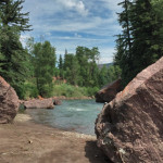
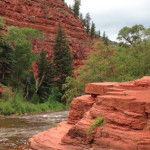
Connects: Highway 133 (West Elk Loop Scenic Byway), Crystal River, Redstone Campground Redstone, CO – Rocky Area The Redstone River Boulders offer climbing with access to the Crystal River. This is a site where various boulders sit off Highway 133…
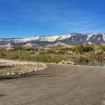
Connects: Colorado River, Colorado River Trail Rifle, CO – Recreation Area The Rifle Boat Ramp is a boat put in and trail network along the Colorado River in Rifle, CO. In 2016, the boat ramp was moved to be located…
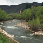
Connects: Roaring Fork River River, Slaughterhouse Bridge (Cemetery Lane Bridge), Rio Grande Trail, Stein Park, Gold Butte, Stein Bridge, Jaffee Park Aspen, CO – Water The Roaring Fork Gorge is a stretch along the Rio Grande Trail in the Roaring…
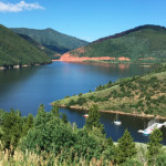
Connects: Frying Pan Road (CR 104), Fryingpan River, Toilet Bowl, Ruedi Recreation Area, Ruedi Marina, Mollie B Campground, Little Maud Campground, Little Mattie Campground, Ruedi Trail, Freeman Mesa Picnic Site, Black Bess Picnic Site, Miller Divide Trail Basalt, CO –…
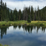
Connects: Conundrum Creek Trail Aspen, CO – Pond Silver Dollar Pond (10,245 ft), also called Silver Dollar Ponds, is a body of water in the Maroon Bells-Snowmass Wilderness accessed by the Conundrum Creek Trail. This is a site 6 miles…
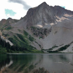
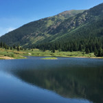
Connects: Four Pass Loop, Three Pass Loop, Aspen to Marble, Maroon-Snowmass Trail, Geneva Lake Trail Snowmass, CO – Lake Snowmass Lake (10,980 ft) is an alpine lake in the Maroon Bells-Snowmass Wilderness accessed at the junction of the Maroon-Snowmass Trail…
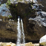
Connects: Hanging Lake Trail, Hanging Lake (7,175 ft) Glenwood Springs, CO – Waterfall Spouting Rock (7,323 ft) is a water fall gushing through rocks that flows into Hanging Lake. The site is located at the top of the Hanging Lake…
Basalt, CO – Reservoir Spring Park Reservoir is a reservoir in the Missouri Heights area near Basalt, CO. It is one of 54 Important Bird Areas (IBA) designated by the Audubon Society in Colorado. This reservoir is private property and…
Connects: Fryingpan River, Frying Pan Road (CR 104), Old Wagon Road, Toner Creek Road Basalt, CO – Rock Strawberry Rock is a rock on the Fryingpan River with a short dirt path to the big rock. This is a site…


