Snowmass Peak (13,627 ft)

Snowmass Lake

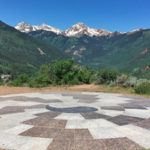
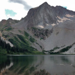
Connects: Maroon Bells-Snowmass Wilderness Snowmass, CO – Mountain Peak Snowmass Peak (13,627 ft) is a peak in the Maroon Bells-Snowmass Wilderness of the White River National Forest near Snowmass, CO. More information about Snowmass Peak can be found at: Wikipedia

Posted in Aspen, Maroon Bells-Snowmass Wilderness, Mountain Peak, Old Snowmass, Rock, Sites, Snowmass Village

South Canyon Archery Range

South Canyon Archery Range

Connects: South Canyon, South Canyon Creek Road (CR 134), South Canyon Bridge, Lower Valley Trail (LoVa Trail) Glenwood Springs, CO – Archery Range South Canyon Archery Range is a bow and arrow shooting range in the South Canyon west of

Posted in Glenwood Springs, Shooting/Archery Range, Sites, South Canyon

South Canyon Bridge

South Canõn Bridge

Connects: Lower Valley Trail (LoVa Trail), South Canyon, Colorado River, South Canyon Creek Road (CR 134), South Canyon Archery Range Glenwood Springs, CO – Bridge South Canyon Bridge, originally spelled South Canõn Bridge, is a historic bridge built in 1915

Posted in Bridge, Glenwood Springs, Historic, Sites, South Canyon Tagged with: ,

South Canyon Hot Springs

South Canyon Hot Springs

Connects: South Canyon, South Canyon Creek Road (CR 134) Glenwood Springs, CO – Hot Springs The South Canyon Hot Springs, also known as Hippy Hot Springs, are a natural hot spring just west of Glenwood Springs in the South Canyon.

Posted in Glenwood Springs, Hot Springs, Sites, South Canyon Tagged with: ,

South Canyon Sledding Hill

South Canyon Sledding Hill

Connects: South Canyon Creek Road (CR 134) Glenwood Springs, CO – Sledding Hill The South Canyon Sledding Hill is a hill in the Glenwood Springs South Canyon that you can sled down that is dog friendly. This is a sled

Posted in Glenwood Springs, New Castle, Sites, Sledding Hill, Snow, Winter Site Tagged with:

South Fork Pass (11,730 ft)

Connects: South Fork Pass Trail Aspen, CO – Mountain Pass South Fork Pass (11,730 ft) is a mountain pass in the Hunter-Fryingpan Wilderness accessed along the South Fork Pass Trail. More information about South Fork Pass Trail can be found

Posted in Hunter-Fryingpan Wilderness, Independence Pass, Mountain Pass, Norrie, Sites

Spiral Point (Yin Yang)

Spiral Point

Connects: Rim Trail Snowmass Village, CO – Viewing Area Spiral Point (9,210 ft), also referred to as the Yin Yang and Snowmass Labyrinth, is a look out site that has 360 degree views of Snowmass, Mt. Daly, Capital Peak and

Posted in Sites, Snowmass Village, Viewing Area Tagged with: , , , ,

Spouting Rock (7,323 ft)

Spouting Rock

Connects: Hanging Lake Trail, Hanging Lake (7,175 ft) Glenwood Springs, CO – Waterfall Spouting Rock (7,323 ft) is a water fall gushing through rocks that flows into Hanging Lake. The site is located at the top of the Hanging Lake

Posted in 1 Mile, 1-3 Miles, Difficult, Dirt, Dog Friendly, Glenwood Springs, Hiking, Rocky, Sites, Trails, Viewing Area, Water, Waterfall, Winter Site

Spring Cave

Connects: Spring Cave Trail Meeker, CO – Cave Spring Cave is a large cave in the South Fork Valley of the White River accessed by the Spring Cave Trail. The cave closed August 15 – April 15. This is a

Posted in Cave, Meeker, Sites

Spring Gulch

Spring Gulch Trail System

Connects: Big Dipper Trail, Bulldogger Trail, Chris Cross Trail, Finlandia Trail, Ginny Lane Trail, Highball Trail, Holdens Trail, Lazy Eight Trail, Little Dipper Trail, Sidewinder Trail, North Star Trail, Out & Back Trail, Paul’s Point, Perry Pass Trail, Rabbit Run

Posted in Carbondale, Course, Nordic Centers and Systems, Nordic Trail, Recreation Area, Sites, Spring Gulch Trail System, Winter Trail Tagged with: , , ,

Spring Park Reservoir

Spring Park Reservoir

Basalt, CO – Reservoir Spring Park Reservoir is a reservoir in the Missouri Heights area near Basalt, CO. It is one of 54 Important Bird Areas (IBA) designated by the Audubon Society in Colorado. This reservoir is private property and

Posted in Basalt, Birding, El Jebel, Reservoir, Sites, Water Tagged with:

St. Benedict’s Monastery

St. Benedict's Monastery

Connects: Capitol Creek Road (CR 9), Monastery Road (CR 9B) Old Snowmass, CO – Monastery St. Benedict’s Monastery is a Trappist monastery that is nestled in a flat area surrounded by high ridges on nearly 4,000 acres in Snowmass, CO.

Posted in Old Snowmass, Sites, Structure Tagged with: , ,

Star Pass (12,330 ft)

Connects: Aspen to Crested Butte Aspen, Crested Butte, CO – Mountain Pass Star Pass (12,330 ft) is a mountain pass in the Elk Mountains between Aspen and Crested Butte, CO. View Larger Map

Posted in Ashcroft, Aspen, Crested Butte, Mountain Pass, Sites

Stein Bridge

Stein Bridge

Connects: Roaring Fork River, Roaring Fork Gorge, Stein Trail, Burlingame Connector Trail (Rio Grande), Rio Grande Trail, Stein Falls Aspen, CO – Bridge Stein Bridge is a pedestrian bridge over the Roaring Fork River that links the Aspen Business Center

Posted in Aspen, Bridge, Sites

Stein Falls

Stein Falls

Connects: Rio Grande Trail, Stein Bridge, Stein Trail Aspen, CO – Ice Stein Falls, also called Sewer Falls, is an ice formation you can climb in the winter accessed along the Rio Grande Trail in Aspen, CO. View Larger Map

Posted in Aspen, Climbing, Sites

Trail Search

Find a trail. Use 1 or all 4 drop downs to customize your search for the right trail.

Dog Friendly:

  or  

Park Search

Find a park. Use the drop downs to find the perfect park.

Dog Friendly:

  or  

Featured and Mentioned On

Questions? Email us at info@aspentrailfinder.com
By using this site you agree to the terms of our User Agreement. Read our Disclaimer.