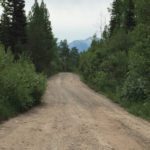
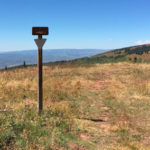
Connects: Highway 133 (West Elk Loop Scenic Byway), McClure Pass (8,755 ft), Raggeds Trail View Larger Map

Connects: Highway 133 (West Elk Loop Scenic Byway), McClure Pass (8,755 ft), Raggeds Trail View Larger Map
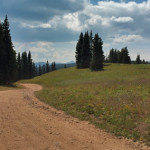
Connects: Ragged Mountain Road (FSR #898), Buck Creek, Spring Creek, Munsey Creek Road (FSR #795) Marble, Paonia, CO – Medium – 14 Miles – Hike, Run, Mountain Bike, Horseback Ride, Dog Friendly – Dirt The Raggeds Trail #820 is an…
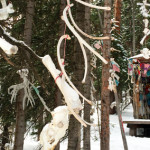
Connects: Aspen Mountain, Walsh’s Ski Run, East Rim Trail Aspen, CO – Shrine The Raoul Wille Shrine is a memorial to Aspen local Raoul Wille who died of altitude sickness climbing Mt. Burunse on Oct. 11, 1998. The shrine is…
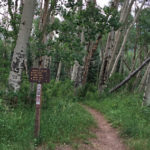
Connects: Marble Quarry Road (CR 3C), Anthracite Pass Trail Marble, CO – Medium – 9 Miles – Hike, Run, Horseback Ride, Dog Friendly – Dirt Raspberry Creek Trail #1968, also called Raspberry Creek Loop, is an intermediate/moderate trail you can…
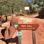
Connects: Carbondale (6,180 ft), Red Hill Road (CR 107), Blue Ribbon Trail, Bogus Trail, Elk Traverse Trail, Faerie Trail, Mushroom Rock Trail, Northside Loop Trail, Outer Loop Trail, Roller Coaster Trail, Sage Loop Trail, Skeeter’s Ridge Trail, Three Gulch Trail,…
Connects: Red Hill, Three Poles Trail, Three Gulch Trail Carbondale, CO – Hard – 1.3 Miles – Hike, Run, Mountain Bike – Dirt Red Hill Road (CR 107), also called Garfield County Road 107, is a difficult road you can…
Connects: Red Mountain Trail (Jeanne Golay Trail), Grandstaff Trail, Olson Trail, Red Mountain Water Treatment Facility, Red Mountain Cross View Larger Map
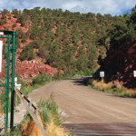
Connects: Rio Grande Trail, Red Mountain Road (FSR #130), Hunter Creek Trail, Hunter Valley Trail, Red Mountain Road (FSR #130) Aspen, CO – Hard – 2.65 Miles – Road Bike, Mountain Bike – Paved/Dirt Red Mountain Road (CR 20) is…
Connects: Cross Trail, Fall Line Trail, Grandstaff Trail, Olson Trail, Red Mountain Cross (7,450 ft) News about the Red Mountain Trail can be found at: Post Independent (November 12, 2017) – Red Mountain trail safety measures taken Red Mountain &…
Connects: Cottonwood Pass Road (CR 10A), Milepost One Trail, Green Gate Trail, Taylor Creek Road (FSR #510), Red Table Trail, FAA Radar Tower, Mount Thomas Trail, Ruedi Trail Basalt, Carbondale, CO – Hard – Hike, Run, Mountain Bike, Horseback Ride,…
Connects: Taylor Creek Road (FSR #510), Basalt Mountain Trail, Cattle Creek Trail Basalt, CO – Hard – 5 Miles – Hike, Run, Mountain Bike, Horseback Ride, Dog Friendly – Dirt Red Table Trail #1909 is a difficult trail you can…
Connects: Aspen Mountain Sundeck, Nature Trail, East Rim Trail, Midnight Mine Road (FSR #118), Richmond Ridge, Grant’s Cabin, Little Annie Road (CR 15G), Hurricane Point (11,535 ft), Taylor Pass (11,930 ft), Express Creek Road (FSR #122), Barnard Hut View Larger…
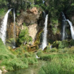
Connects: Rifle Falls State Park, Coyote Trail, Mountain Mist Amphitheater, Rifle Falls Caves, Bobcat Trail, Squirrel Trail Rifle, CO – Waterfall Rifle Falls (6,550 ft) is a 70-foot triple waterfall flowing over a dam on East Rifle Creek in Rifle…
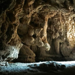
Connects: Rifle Falls State Park, Rifle Falls, Coyote Trail, Bobcat Trail Rifle, CO – Caves The Rifle Falls Caves are two limestone caves in the Rifle Falls State Park. Both caves are located a short distance from Rifle Falls off…
Connects: Highway 325, Rifle Falls (6,550 ft), Squirrel Trail, Coyote Trail, Mountain Mist Amphitheater, Bobcat Trail, Cascades (Rifle), Rifle Falls State Fish Hatchery Rifle, CO – Recreation Area Rifle Falls State Park is a 48-acre park located 13 miles off…


