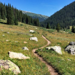
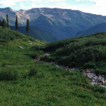
Connects: Lost Man Loop, Independence Pass Road (HWY 82), Lost Man Campground, Midway Creek Trail, Lost Man Reservoir (10,580 ft) , South Fork Pass Trail, Lost Man Lake (12,450 ft), Lost Man Pass (12,805 ft), Independence Lake (12,497 ft), Linkins…

Connects: Lost Man Loop, Independence Pass Road (HWY 82), Lost Man Campground, Midway Creek Trail, Lost Man Reservoir (10,580 ft) , South Fork Pass Trail, Lost Man Lake (12,450 ft), Lost Man Pass (12,805 ft), Independence Lake (12,497 ft), Linkins…
Connects: Aspen to Marble, Marble, Beaver Lake (7,945 ft), Four Pass Loop, Lead King Loop, Hasley Pass (12,144 ft), Frigid Air Pass (12,405 ft), Schofield Pass (10,700 ft), Yule Pass (11,300 ft) Marble, Crested Butte, CO – Hard – Hike,…
Connects: Four Pass Loop, Three Pass Loop, Maroon Lake (9,585 ft), Maroon Bells Scenic Trail, West Maroon Portal Trail, Crater Lake Trail, Crater Lake (10,076 ft), West Maroon Trail, Minnehaha Gulch, Willow Lake Trail, Buckskin Pass (12,462 ft), Snowmass Lake…
Connects: Castle Creek Road (CR 15), Little Annie Road (CR 15G), Hidden Treasure Trail, Aspen Mountain Sundeck, Richmond Hill Road (FSR #123), Nature Trail
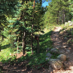
Connects: Independence Pass Road (HWY 82), Lost Man Campground, Lost Man Trail, Midway Pass (11,847 ft), Woody Creek Trail, Hunter Creek Trail Aspen, CO – Hard – 8.8 Miles – Hike, Run, Horseback Ride, Dog Friendly – Dirt Midway Creek…
Connects: Aspen to Crested Butte, Castle Creek Road (CR 15), Cooper Creek Road (Iron Mine Road), Mace Cabin, Pearl Pass Bridge, Pearl Pass Road (FSR #102), Montezuma Basin, Castle/Conundrum Peak Trail View Larger Map
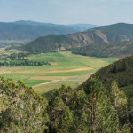
Connects: Dinkle Lake Road (FSR #311), Thomas Lakes Trail, Hay Park Trail, Thomas Lakes (10,200 ft), East Sopris Peak (12,965 ft), West Sopris Peak (12,965 ft) Basalt, Carbondale, CO – Hard – 7 Miles – Hike, Run, Dog Friendly –…
Connects: Red Hill, Three Poles Trail, Blue Ribbon Trail Carbondale, CO – Hard – 0.6 Miles – Hike, Run, Dog Friendly – Dirt Mushroom Rock Trail is a difficult trail you can hike and run that is dog friendly. This…
Connects: The Crown Basalt, CO – Hard – 1.6 Miles – Hike, Run – Dirt Nancy’s Path is a difficult trail you can hike and run. This is a 1.6 mile rocky trail in the Emma area of Basalt, CO.…
Connects: Hagerman Pass Road (FSR #105) Leadville, CO – Hard – 9.4 Miles – Hike, Horseback Ride, Dog Friendly – Dirt Native Lake/Highline Trail is a difficult trail you can hike and horseback ride that is dog friendly. This is…
Connects: Lincoln Creek Road (FSR #106), New York Lake (11,950 ft) Aspen, CO – Hard – 4.2 Miles – Hike, Run, Horseback Ride, Dog Friendly – Dirt New York Creek Trail #2182 is a difficult trail you can hike, run,…
Connects: Nickelson Creek Road (CR 9D), Capitol Creek Trail, Hunter Pass Trail, Haystack Mountain Trail Old Snowmass, CO – Hard – Hike, Run, Horseback Ride, Dog Friendly – Dirt Nickelson Creek Trail #1962 is a difficult trail you can hike,…
Connects: Four Pass Loop, Geneva Lake Trail, Fravert Basin Trail (North Fork Trail) Marble, CO – Hard – 1.1 Miles – Hike, Run, Horseback Ride, Dog Friendly – Rocky/Dirt North Fork Cutoff Trail is a difficult trail you can hike,…
Connects: Aspen to Crested Butte, Montezuma Basin Road (FSR #102), Tagert Hut, Green-Wilson Hut, Pearl Pass Ashcroft, CO – Hard – Hike, Run, Mountain Bike, Horseback Ride, Dog Friendly – Rocky/Dirt Pearl Pass Road (FSR #102) is a difficult road…
Connects: Highway 133 (West Elk Loop Scenic Byway), Lily Lake Trail Redstone, CO – Hard – 3 Miles – Hike, Horseback Ride, Dog Friendly – Dirt Placita Trail #1966 is a difficult trail you can hike and horseback ride that…


