Connects: Lead King Loop, Crystal City Road (FSR #314), Legend of Tall Tree Trail Marble, CO – Lake Lizard Lake (8,705 ft) is a 5-acre lake with an unknown depth along Crystal City Road (FSR #314) just a short distance…

Connects: Lead King Loop, Crystal City Road (FSR #314), Legend of Tall Tree Trail Marble, CO – Lake Lizard Lake (8,705 ft) is a 5-acre lake with an unknown depth along Crystal City Road (FSR #314) just a short distance…
Connects: Crystal River, Gunnison County Road 3 Marble, CO – Airstrip The Marble Airstrip (7,800 ft), jokingly referred to as Marble International Airport, is a 4,000 foot airstrip in a private field between the Crystal River and Gunnison County Road…
Connects: Gunnison County Road 3 Marble, CO – Cemetery The Marble Cemetery is an old cemetery along Gunnison County Road 3 in Marble, CO. View Larger Map
Connects: Gunnison County Road 3, Crystal River, Marble Mill Site Park, Marble Quarry Road (CR 3C) Marble, CO – Disc Golf The Marble Disc Golf Course is a 9 hole course around the Marble Mill Site in Marble, CO. More…
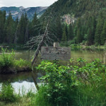
Connects: Gunnison County Road 3, Crystal River, Marble Disc Golf Course, Marble Quarry Road (CR 3C) Marble, CO – Historic Site The Marble Mill Site Park is a 25 acre historic site that is now a park with large marble…
Connects: Gunnison County Road 3, Marble Mill Site Park, Marble Disc Golf Course, Crystal River, Raspberry Creek Trail, Yule Pass Trail, Yule Marble Quarry Marble, CO – Hard – 3.1 Miles – Hike, Run, Mountain Bike – Dirt Marble Quarry…
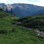
Connects: Aspen to Marble, Marble, Beaver Lake (7,945 ft), Four Pass Loop, Lead King Loop, Hasley Pass (12,144 ft), Frigid Air Pass (12,405 ft), Schofield Pass (10,700 ft), Yule Pass (11,300 ft) Marble, Crested Butte, CO – Hard – Hike,…
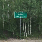
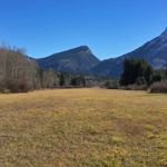
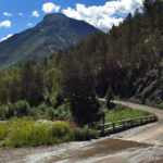
Connects: Highway 133 (West Elk Loop Scenic Byway), Huntsman Ridge Road (FSR #517), Ragged Mountain Road (FSR #898) Marble, CO – Mountain Pass McClure Pass (8,755 ft) is a mountain pass accessed by Highway 133 (West Elk Loop Scenic Byway)…
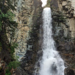
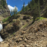
Marble, CO – Waterfall Milton Falls is a waterfall on Milton Creek claimed to be the Original Coors Falls. The waterfall is accessed by a short dirt trail (less than 1/2 mile) through private property off Deer Trail Road in…
Connects: Anthracite Pass Trail Marble, CO – Hard – 6.4 Miles – Hike, Run, Horseback Ride, Dog Friendly – Rocky/Dirt North Anthracite Trail #832 is a difficult trail you can hike, run, and horseback ride that is dog friendly. This…
Connects: Four Pass Loop, Geneva Lake Trail, Fravert Basin Trail (North Fork Trail) Marble, CO – Hard – 1.1 Miles – Hike, Run, Horseback Ride, Dog Friendly – Rocky/Dirt North Fork Cutoff Trail is a difficult trail you can hike,…
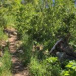
Connects: Lead King Loop, Lead King Basin Road (FSR #315), Avalanche Pass Trail, Carbonate Creek Trail, Arkansas Mountain Trail Marble, CO – Medium – 2 Miles – Hike, Run, Dog Friendly – Dirt North Lost Trail #1967 is an intermediate/moderate…
Connects: Highway 133 (West Elk Loop Scenic Byway), McClure Pass (8,755 ft), Raggeds Trail View Larger Map
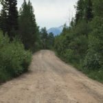
Connects: Ragged Mountain Road (FSR #898), Buck Creek, Spring Creek, Munsey Creek Road (FSR #795) Marble, Paonia, CO – Medium – 14 Miles – Hike, Run, Mountain Bike, Horseback Ride, Dog Friendly – Dirt The Raggeds Trail #820 is an…
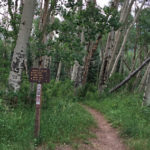
Connects: Marble Quarry Road (CR 3C), Anthracite Pass Trail Marble, CO – Medium – 9 Miles – Hike, Run, Horseback Ride, Dog Friendly – Dirt Raspberry Creek Trail #1968, also called Raspberry Creek Loop, is an intermediate/moderate trail you can…


