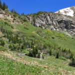
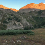
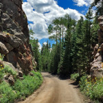
Connects: Avalanche Pass Trail Marble, CO – Mountain Pass Avalanche Pass (12,100 ft) is a high mountain pass accessed along the Avalanche Pass Trail in the Maroon Bells-Snowmass Wilderness near Marble, CO. View Larger Map

Connects: Avalanche Pass Trail Marble, CO – Mountain Pass Avalanche Pass (12,100 ft) is a high mountain pass accessed along the Avalanche Pass Trail in the Maroon Bells-Snowmass Wilderness near Marble, CO. View Larger Map
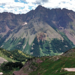
Connects: Four Pass Loop, Three Pass Loop, Aspen to Marble, Maroon-Snowmass Trail Aspen, CO – Mountain Pass Buckskin Pass (12,462 ft) is one of four passes along the Four Pass Loop. This is a mountain pass in the Maroon Bells-Snowmass…
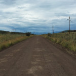
Connects: Cottonwood Pass Road (CR 10A) Carbondale, CO – Mountain Pass Cottonwood Pass (8,290 ft) is a mountain pass accessed by Cottonwood Pass Road (CR 10A) near Carbondale, CO. There are no signs that mark the peak of Cottonwood Pass.…
Connects: Cattle Creek Road (CR 113), Cottonwood Pass (8,290 ft), Red Table Road (FSR #514)
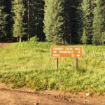
Connects: Eagle-Thomasville Road (FSR #400), Mount Thomas Trail Thomasville, CO – Mountain Pass Crooked Creek Pass (10,009 ft) is a mountain pass along Eagle-Thomasville Road (FSR #400) near Basalt, CO. Distances: Crooked Creek Pass to Thomasville – 12 Miles Crooked…
Connects: East Maroon Trail Aspen, CO – Mountain Pass East Maroon Pass (11,820 ft) is a mountain pass in the Maroon Bells-Snowmass Wilderness accessed along the East Maroon Trail. This is a mountain pass between Aspen and Crested Butte, CO.…
Connects: Three Pass Loop, East Snowmass Trail, Willow Lake Trail Snowmass, CO – Mountain Pass East Snowmass Pass (12,680 ft) is a mountain pass in the Maroon Bells-Snowmass Wilderness near Snowmass, CO. The pass is accessed by the East Snowmass…
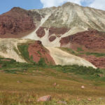
Connects: Electric Pass Trail, Conundrum Creek Valley Aspen, CO – Mountain Pass Electric Pass (13,494 ft) is a mountain pass in the Maroon Bells-Snowmass Wilderness accessed by Electric Pass Trail near Ashcroft, CO. Electrical storms often hit the pass, typically…
Connects: Four Pass Loop, Marble to Crested Butte, West Maroon Trail, Fravert Basin Trail Aspen, CO – Mountain Pass Frigid Air Pass (12,405 ft) is one of four passes along the Four Pass Loop. This is a mountain pass in…
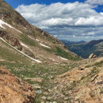
Connects: North Fork Trail Aspen, CO – Mountain Pass Fryingpan Pass (12,438 ft) is a high mountain pass accessed by the North Fork Trail. This is a mountain pass in the Mt. Massive Wilderness. Distances: North Fork Trailhead to Fryingpan…
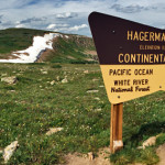
Connects: Hagerman Pass Road (FSR #105) Leadville, CO – Mountain Pass Hagerman Pass (11,925 ft) is a mountain pass along the continental divide accessed by Hagerman Pass Road (FSR #105) that connects Basalt to Leadville. Hagerman Pass Road is closed…
Connects: Colorado Midland Trail (Hagerman Tunnel Trail), Douglass City, Opal Lake (11,390 ft), Hagerman Lake (11,330 ft) Leadville, CO – Historic Hagerman Tunnel is an old trail tunnel between Leadville and Basalt, CO. The tunnel was the highest railroad tunnel…
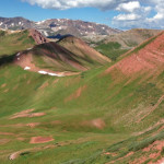
Connects: Marble to Crested Butte, Hasley Basin Trail Aspen, CO – Mountain Pass Hasley Pass (12,144 ft) is a high mountain pass along the Hasley Basin Trail. This is a mountain pass in the Maroon Bells-Snowmass Wilderness. Four Pass Loop…
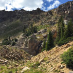
Connects: Hagerman Pass Road (FSR #105) Nast, CO – Viewing Area Hell Gate, also called Hell Gap, is a narrow section along Hagerman Pass Road (FSR #105) to Hell Gap where the valley drops far below and the road winds…
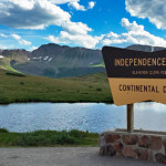
Connects: Independence Pass Road (HWY 82), Independence Pass Scenic Trail, Continental Divide Trail (Independence Pass) Aspen, CO – Mountain Pass Independence Pass (12,095 ft), originally called Hunter Pass, is a mountain pass along the Continental Divide accessed by Highway 82…


