


Connects: No Problem Joe Trail, Herron Park, Newbury Park, Oklahoma Flats Trail, Rio Grande Park, John Denver Sanctuary, Sheely Bridge (Ron Krajian Bridge), Red Mountain Road (CR 20), Hunter Creek Trail, Grindlay Bridge, Music Tent Trail, Meadows Trail, Meadows Bridge, Cemetery Lane Trail, Slaughterhouse Bridge (Cemetery Lane Bridge), McLain Flats Road (CR 19), Stein Park, Roaring Fork Gorge, Sunnyside Trail, Stein Bridge, Stein Falls (Winter), Jaffee Park, Aspen Mass Trail, Woody Creek Road, Wheatley Cemetery, Basalt/Old Snowmass Trail, River Access Trail, Lazy Glen Bridge, Wingo Bridge, Roaring Fork Club Trails (Winter), Southside Trail, Grace Shehi Bike Park, Basalt High School Trail, Emma Schoolhouse, Downtown Basalt-Willits Trail, Glassier Trail, Rock Bottom Ranch, Rock Bottom Ranch Trails, Buckhorn Trail, Catherine Bridge, Rio Grande ARTway, Derail Park, Crystal Valley Trail, Highway 133 (West Elk Loop Scenic Byway), Cattle Creek Loop, Satank Bridge, Spring Valley Loop, Rosebud Cemetery, Glenwood Springs River Trail, Boy Scout Loop, River Trail Dog Park, 14th Street Bridge, Two Rivers Park
![]()
![]()
![]()
![]()
![]()
![]()
![]()
![]()
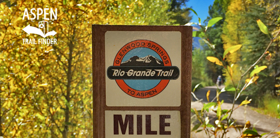
A mile marker on the Rio Grande Trail from Aspen to Glenwood
Aspen, Basalt, Carbondale, Glenwood Springs, CO – Easy – 42 Miles – Walk, Hike, Run, Road Bike, Mountain Bike, Horseback Ride, Dog Friendly- Paved/Gravel
The Rio Grande Trail is an easy trail you can walk, hike, run, bike, and horseback ride that is dog friendly. The trail follows the corridor of the historic Denver and Rio Grande Western Railroad, whose first train reached Aspen in October 1887. The mostly paved trail spans the entire Roaring Fork Valley and connects Aspen, Basalt, Carbondale, and Glenwood Springs. A gravel section stretches from Cemetery Lane to Woody Creek. Road bikers can use McLain Flats Road as an alternative path around this section of the trail.
Distances:
Puppy Smith Street Post Office to Cemetery Lane Trail – 1.8 Miles
Puppy Smith Street Post Office to Basalt – 18.1 Miles
Henry Stein Park to Woody Creek Tavern – 6 Miles
Woody Creek Trailhead to Arciero/Old Snowmass Trailhead – 7 Miles
Arciero/Old Snowmass Trailhead to Basalt High School Trailhead – 3.6 Miles
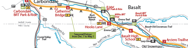
Hooks Lane Trailhead to Catherine Bridge – 4.5 Miles
Rock Bottom Ranch to Catherine Bridge – 2.5 Miles
News about the Rio Grande Trail can be found at:
Post Independent (August 10, 2017) – RFTA to allow E-bikes on Rio Grande Trail
Aspen Daily News (March 1, 2015) – From trains to trail on the Rio Grande
The Aspen Times (May 6, 2011) – Watch for heavenly bodies along the Rio Grande Trail
More information about the Rio Grande Trail can be found at:
Roaring Fork Transportation Authority – Rio Grande Trail
White River National Forest – Rio Grande Trail to Woody Creek (Hiking)
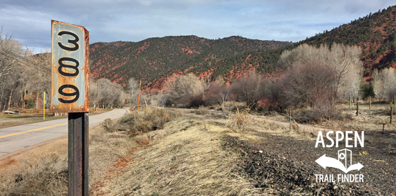
A mile marker sign along the Rio Grande Trail
“What do these tell us?
You may notice these numbered signs along the trail, mounted on sections of railroad track. They indicate the milage from Union Station in Denver as traveled on the original Denver & Rio Grande Western Railroad right of way.
Why such a large number when Denver is only 150 miles away you ask? The rail line originally passed through the towns of Pueblo, Leadville, and Minturn on its way to Aspen.”
![]()
![]()
![]()
![]()
![]()
![]()
![]()
![]()
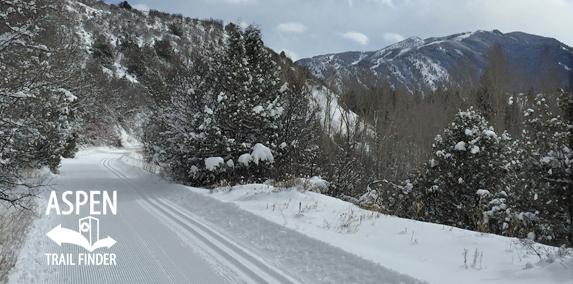
Groomed nordic tracks on the Rio Grande Trail
Aspen, Basalt, Carbondale, Glenwood Springs, CO – Easy – 42 Miles – Walk, Snowshoe, Run, Classic XC Ski, Skate Ski, Fat Bike, Dog Friendly – Plowed Snow/Groomed
Rio Grande Trail is an easy winter trail you can classic cross-country ski, skate ski, and fat bike that is dog friendly. The trail is plowed and maintained from Aspen to Cemetery Lane. This is a 32.2 KM (20 Mile) groomed nordic trail when conditions allow from Aspen and Basalt, CO.
Grooming reports and trail maps can be found at Aspen/Snowmass Nordic Trail System.
The section of the Rio Grande Trail from Rock Bottom Ranch in Basalt to Catherine Bridge in Carbondale is closed seasonal from December 1 to May 1. A detour route with signs marking it follows the Highway 82 Access Road around this stretch of the trail.
More information about the Rio Grande Trail can be found at:
Roaring Fork Transportation Authority – Rio Grande Trail
View Larger Map

View Larger Map


