Connects: Tabor Creek Trail Aspen, CO – Lake Tabor Lake (12,310 ft) is an alpine lake accessed by the Tabor Creek Trail in the Collegiate Peaks Wilderness near Aspen, CO. More information about Tabor Lake can be found at: White…

Taylor Lake (11,550 ft)
Connects: Taylor Pass (11,930 ft), Express Creek Road (FSR #122), Richmond Hill Road (FSR #123) Ashcroft, CO – Lake Taylor Lake (11,550 ft) is an alpine lake below Taylor Pass (11,930 ft) near Ashcroft accessed by Express Creek Road (FSR…
Taylor Pass (11,930 ft)
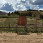
Connects: Express Creek Road (FSR #122), Richmond Hill Road (FSR #123), Taylor Lake (11,550 ft) Ashcroft, CO – Mountain Pass Taylor Pass (11,930 ft) is a mountain pass near Ashcroft accessed by Express Creek Road (FSR #122) and Richmond Hill…
Terral Wade Bridge (Tiehack Nordic Bridge)
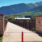
Connects: Maroon Creek Road (CR 13), Aspen Recreation Center, Moore Trail, Iselin/Rotary Trail, Iselin Park, Whoa Nelly Sledding Hill (Winter), Maroon Creek Trail, Government Trail, Aspen Fat Bike Loop, Tiehack Trail, Tiehack Summer Road, Tiehack Uphill Route (Winter) Aspen, CO…
Posted in Aspen, Bridge, Sites Tagged with: Tiehack Bridge, Tiehack Nordic Bridge, Tiehack Pedestrian Bridge
Tiehack Summer Road
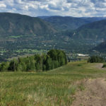
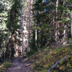
Connects: Terral Wade Bridge (Tiehack Nordic Bridge), Tiehack Trail, Oregon Trail, Government Trail, Buttermilk Summer Road, Buttermilk Trail Aspen, CO – Hard – 2.75 Miles – Hike, Run, Mountain Bike, Dog Friendly – Dirt The Tiehack Summer Road is a…
Posted in 1-3 Miles, 3 Miles, Aspen, Buttermilk Mountain, Difficult, Dirt, Dog Friendly, Hard, Hiking, Mountain Biking, Running, Trails
Tiehack Trail

Connects: Terral Wade Bridge (Tiehack Nordic Bridge), Tiehack Summer Road, Oregon Trail, Government Trail, Buttermilk Summer Road Aspen, CO – Hard – 1.5 Miles – Hike, Run, Dog Friendly – Dirt The Tiehack Trail is a difficult trail you can…
Tiehack Uphill Route
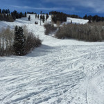
Connects: Terral Wade Bridge (Tiehack Nordic Bridge), Tiehack Warming Hut, Tiehack Express Lift, Summit Express Lift, West Buttermilk Warming Hut Aspen, CO – Hard – 1.75 Miles – Uphill, Snowshoe – Snow The Tiehack Uphill Route is a difficult route…
Posted in 1-3 Miles, Aspen, Buttermilk Mountain, Hard, Skinning, Snow, Snowshoeing, Trails, Uphilling (SkiMo), Winter Trail
Tiehack Warming Hut
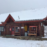
Connects: Tiehack Express Lift, Tiehack Uphill Route, Owl Creek Trail (Winter) Aspen, CO – Hut The Tiehack Warming Hut is a structure with restrooms at the bottom of the Tiehack Express Lift on Buttermilk Mountain in Aspen, CO. View Larger…
Tootsie Roll Trail
Connects: Smuggler Mountain, Smuggler Mountain Road (FSR #131), Lollipop Trail Aspen, CO – Medium – 1.06 Miles – Hike, Run, Mountain Bike, Dog Friendly – Dirt Tootsie Roll Trail is an intermediate/moderate trail you can hike, run and mountain bike…
Posted in 1 Mile, 1-3 Miles, Aspen, Dirt, Dog Friendly, Hiking, Medium, Moderate, Mountain Biking, Running, Smuggler Mountain, Trails
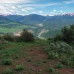
Tourtolotte Park
Connects: Aspen Mountain Ski Area Aspen, CO – Historic Tourtolotte Park is an old mining town, now an open area below Buckhorn Ski Run, on Aspen Mountain in Aspen, CO. More information about Tourtolotte Park can be found at: The…
Triangle Pass (12,900 ft)
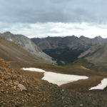
Connects: Triangle Pass Trail, Conundrum Creek Trail Aspen, Crested Butte, CO – Mountain Pass Triangle Pass (12,900 ft) is a mountain pass in the Maroon Bells-Snowmass Wilderness between Aspen and Crested Butte, CO. The pass is accessed by the Triangle…
Triangle Pass Trail
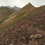
Connects: Copper Creek Trail, Copper Lake (11,320 ft), East Maroon Trail, Triangle Pass (12,900 ft), Conundrum Creek Trail Gothic, CO – Hard – 2 Miles – Hike, Run, Horseback Ride – Rocky Triangle Pass Trail is a difficult trail you…
Posted in 1-3 Miles, 2 Miles, Aspen, Crested Butte, Difficult, Gothic, Hard, Hiking, Horseback Riding, Maroon Bells-Snowmass Wilderness, Rocky, Running, Trails
Triangle Peak Trail
Connects: Arbaney Traverse, Red Rim Road, Triangle Peak (9,223 ft), Arbaney Kittle Trail Aspen, CO – Hard – 3 Miles – Hike, Run, Mountain Bike, Horseback Ride, Dog Friendly – Dirt Triangle Peak Trail is a difficult trail you can…
Posted in 1-3 Miles, 3 Miles, Aspen, Difficult, Dirt, Dog Friendly, Hard, Hiking, Horseback Riding, Mountain Biking, Running, Trails, Woody Creek Tagged with: Trail 534.2
Twin Lakes (9,195 ft)
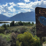
Connects: Village of Twin Lakes, Independence Pass Road (HWY 82), Interlaken Trail, Interlaken Historic Resort Twin Lakes, CO – Lake Twin Lakes (9,195 ft) are alpine lakes by the Historic Village of Twin Lakes in the San Isabel National Forest…
Uncle Wiggley’s Tree Farm
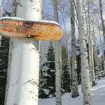
Connects: Aspen Mountain, Copper Bowl Aspen, CO – Memorial Uncle Wiggley’s Tree Farm is a section of Aspen Trees off Copper Bowl on Aspen Mountain in Aspen, CO. An engraved sign on an Aspen tree reads, “Howie Mayer AMSP from…
Posted in Aspen, Aspen Mountain (AJAX), Memorial, Shrine, Sites Tagged with: Uncle Wiggly’s Tree Farm


