
Connects: Snowmass Bike Park, Elk Camp Gondola, Vapor Trail (Downhill Only) Snowmass Village, CO – Hard – 1.9 Miles – Mountain Bike – Dirt The Animal Crackers Trail is a difficult downhill only mountain biking trail in Snowmass Village, CO.…

Connects: Snowmass Bike Park, Elk Camp Gondola, Vapor Trail (Downhill Only) Snowmass Village, CO – Hard – 1.9 Miles – Mountain Bike – Dirt The Animal Crackers Trail is a difficult downhill only mountain biking trail in Snowmass Village, CO.…
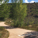
Connects: ABC Trail, Stein Trail Aspen, CO – Easy – 0.18 Miles – Walk, Run, Road Bike, Dog Friendly – Paved The Annie B. Mitchell Trail is an easy trail you can walk, run, and bike that is dog friendly.…
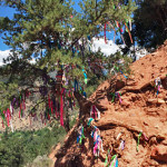
Connects: Pioneer Cemetery Trail Glenwood Springs, CO – Decoration Annie’s Wishing Tree is a tree full of ribbons started by Annie Zancanella while going through cancer treatments. The tree has ribbons tied to it with written wishes, dreams, prayers, and…
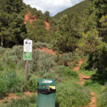
Connects: North Anthracite Trail, Yule Creek Trail, Raspberry Creek Trail Marble, CO – Hard – Hike, Run, Horseback Ride, Dog Friendly – Rocky/Dirt Anthracite Pass Trail #1969 is a difficult trail you can hike, run, and horseback ride that is…
We built an app. It’s kind of awesome. Every trail, searchable, app size.
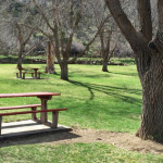
Connects: Talbott Trail New Castle, CO – Park Apple Tree Park is an open area in the Apple Tree subdivision of New Castle, CO. This park includes: Restrooms Playground Basketball Court Horseshoe Pit Gazebo View Larger Map
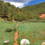
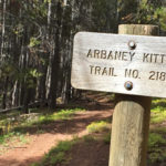
Connects: Arbaney Traverse, Arbaney Kittle West Trail, Arbaney Kittle Trail Basalt, CO – Hard – 1.15 Miles – Hike, Mountain Bike, Dog Friendly – Dirt Arbaney Kittle Gulch Trail is a difficult trail you can hike and mountain bike that…
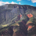
Connects: Arbaney Traverse, Basalt/Old Snowmass Trail, Arbaney Kittle West Trail, Arbaney Kittle Gulch Trail, Fryingpan Overlook (8,290 ft), Triangle Peak Trail, Red Rim Road (FSR #534), Red Canyon Trail, Kobey Trail Basalt, CO – Hard – 17.5 Miles – Hike,…
Connects: Arbaney Traverse, Arbaney Kittle Gulch Trail, Arbaney Kittle Trail, Fryingpan Overlook (8,290 ft) Basalt, CO – Hard – 1.95 Miles – Hike, Run, Mountain Bike, Dog Friendly – Dirt Arbaney Kittle West Trail is a difficult trail you can…
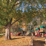
Connects: Basalt History Tour, Berm Trail, Basalt Community Pool, Arbaney Barn, Arbaney Residence, Frying Pan Coke Ovens Basalt, CO – Park Arbaney Park is a large open area in a subdivision in Basalt, CO. This park includes: Restrooms Playground (Structures…
Connects: Basalt/Old Snowmass Trail, Arbaney Kittle Trail, Arbaney Kittle West Trail, Arbaney Kittle Gulch Trail, Fryingpan Overlook (8,290 ft), Triangle Peak Trail, Red Rim Road (FSR #534), Triangle Peak (9,223 ft), Red Canyon Trail, Kobey Trail, Forest Service Road #513,…
Connects: Lead King Loop, Lead King Basin Road (FSR #315), Silver Creek Trail, North Lost Trail, Carbonate Creek Trail Marble, CO – Hard – 5.2 Miles – Hike, Run, Horseback Ride, Dog Friendly – Dirt Arkansas Mountain Trail #1965 is…
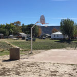
Connects: Arnold Ave Rifle, CO – Park Arnold Park is a neighborhood park in Rifle, CO. This park includes: Basketball Court Playground View Larger Map
Connects: Sheely Bridge (Ron Krajian Bridge) Aspen, CO – Park The Art Park is a park space in Aspen, CO. This park includes: Sculptures Pond View Larger Map
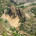
Connects: Glenwood Canyon, Scout Trail Glenwood Springs, CO – Viewing Area Artist Point (6,540 ft) is a scenic overlook above Horseshoe Bend Park in the Glenwood Canyon on the Scout Trail in Glenwood Springs, CO. Distances: Scout Trailhead (Sign) to…


