Crooked Creek Pass (10,009 ft)

1 Star2 Stars3 Stars4 Stars5 Stars6 Stars7 Stars8 Stars9 Stars10 Stars (8 votes, avg: 6.25 out of 10)
Loading...

Connects: Eagle-Thomasville Road (FSR #400), Mount Thomas Trail

Camera_Icon_48Aspen Trail Finder Hiking TrailsAspen Trail Finder Running TrailsMountain Biking Trailshorse friendly trailDog_Paw_Icon_48

Crooked Creek Pass

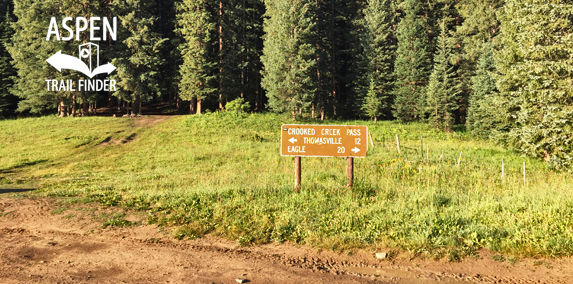
Crooked Creek Pass (10,009 ft) along Eagle-Thomasville Road (FSR #400)

Thomasville, CO – Mountain Pass

Crooked Creek Pass (10,009 ft) is a mountain pass along Eagle-Thomasville Road (FSR #400) near Basalt, CO.

Distances:
Crooked Creek Pass to Thomasville – 12 Miles
Crooked Creek Pass to Eagle – 20 Miles

More information on Crooked Creek Pass can be found at:
White River National Forest – Crooked Creek Pass / Sylvan Lake


View Larger Map

Comments

Subscribe
Notify of
guest
1 Comment
Inline Feedbacks
View all comments
Johnnyh@msn.com
Johnnyh@msn.com
4 years ago

Ugliest place I’ve ever been. You couldn’t drag me back up there. Don’t go it will make you sick.

Posted in Basalt, Meredith, Mountain Pass, Nast, Sites, Thomasville Tagged with:

By using this site you agree to the terms of our User Agreement. Read our Disclaimer.

Trail Search

Find a trail. Use 1 or all 4 drop downs to customize your search for the right trail.

Dog Friendly:

  or  

Park Search

Find a park. Use the drop downs to find the perfect park.

Dog Friendly:

  or  

Featured and Mentioned On

Questions? Email us at info@aspentrailfinder.com
By using this site you agree to the terms of our User Agreement. Read our Disclaimer.