


Connects: Colorado River, Grand River Park Loop, Capt. Will “Pyro” DuBois Memorial
Grand River Park in New Castle
New Castle, CO – Park
Grand River Park is a large open area along the Colorado River in New Castle, CO. This park includes:
Restrooms
Playground
Infant Swings
Child Swings
Soccer Field
Pond
1. Park hours are sunrise to sunset. No Camping.
2. No glass containers.
3. Alcoholic beverages are not allowed.
4. Noise Ordinances strictly enforces; no amplified sound systems.
5. Dogs must be on a controlled leash or under voice control*.
6. Pet waste must be picked up and disposed of in a pet waste receptacle or trash can.
7. No firearms, hunting, archery, or fireworks.
8. Parking in parking lots only; no motorized vehicles in park. Parking is prohibited after sunset.
9. No golfing.
10. No model aircraft flying or rocketry anytime during field usage.
11. Charcoal fires in grills only. The burning of wood, coal, or any other combustible fuel is prohibited.
12. Tent or canopy staking by permit only.
13. No outside vendors; no political, religious, commercial, or other solicitations without a permit.
14. Deposit trash in trash receptacles. if receptacles are full, please pack out your trash. New Castle promotes recycling. Please recycle all your plastic and aluminum.
15. Ball field and Soccer field use must honor scheduled use; organized leagues must schedule through New Castle Recreation Department, 984-3352
16. No climbing on buildings, fences, trees.
17. Park shelters and picnic areas can be reserved for gatherings and events through New Castle Recreation Department 984-3352.
Park and Open Space users are subject to the provisions of the Town Code and the Town’s Parks and Open Space Regulations, all of which are available on the Town’s website: www.newcastlecolorado.org
*A dog is under “voice control” when the owner, keeper, or harborer of the dog controls the behavior of a dog that is not leashed or otherwise physically restrained sufficient that the dog does not, without regard to circumstances or distractions:
1. Charge, chase, or otherwise display aggression toward any person or behave toward any person in a manner that a reasonable person would find harassing or disturbing;
2. Charge, chase, or otherwise display aggression toward any dog;
3. Charge, chase, harass, or disturb wildlife or livestock; or
4. Fail to come to and stay with the owner or keeper immediately upon command by such person. Voice control dos not exist unless the owner, keeper, or harborer exercises this command authority at all times to keep the dog within the requirements of this definition.“
Vulcan Mine & Vulcan City
Looking east up the Colorado River you can view the remnants of the Vulcan coal mine. In the 1890s, a small community called Vulcan City cropped up below the mine, near the river. The community consisted mainly of homes and tenement quarters. Miners and their families had to make the two mile commute, using the Roderick Ferry across the Colorado River, to New Castle for their amenities. The barren scar that runs across the Grand Hogback behind you represents the end of the Vulcan Mine. That lifeless area is caused by a fire that sill burns inside the mountain that once produced some of the finest coal in the state. Three deadly mine explosions are responsible for igniting the coal vein. The explosions occurred in 1896, 1913, and 1918. A total of 89 men’s lives came to a violent end when methane explosions occurred in the Vulcan Mine.”
The Colorado River
The river before you was known as the “Grand River” until Congress changed its name to the Colorado in 1921. At 1,450 miles, the Colorado River is the seventh longest in the United States. It drains 246,000 square miles in parts of seven states and a small portion of northern Mexico. The Colorado River irrigates 3 million acres of farmland and supplies water to 30 million people. These demands place enormous stress on the river, as agriculture, domestic use, industry, recreation, and wildlife habitat all compete for a limited supply of water. In Colorado, water flows change considerably between draught years and high water years. The amount of water is dependent on winter snowfall. The river has cut deep canyons because its headwaters near Grand Lake are 10,000 feet higher than its mouth in Baja California. East of here, Glenwood Canyon has 1,000 foot cliffs, and far southwest, the Grand Canyon drops 6,000 feet from the rim to the river.”
Native Fish in the Upper Colorado River Basin
Geographically speaking, the upper Colorado River basin is the Colorado River and its tributaries upstream of Lake Powell. It is home to 14 native fish species, four of which are endangered. These four fish – the Colorado pikeminnow, razorback sucker, ponytail, and humpback chub – evolved in the Colorado River basin and exist nowhere else on earth. From the high mountains of Wyoming and Colorado, the colorful Colorado River drops more than two miles in elevation on its 1,700-mile journey to the Gulf of California. For long stretches, red canyon walls bound the river channel. River flows fluctuate widely form season to season and from year to year. It took tough, adaptable creatures to survive in this powerful, narrow, river system. The 14 species of fish which are native to the upper Colorado are: the Colorado pikeminnow, ponytail, humpback chub, razorback sucker, Colorado River cutthroat trout, Rocky Mountain whitefish, roundtable chub, speckled dace, Kendall Warm Springs dace, flannelmouth sucker, mountain sucker, bluehead sucker, mottled sculpin, and the paiute sculpin.
“Source: US Fish and Wildlife Service
John C. Frémont, “The Pathfinder” & Kit Carson
On June 1, 1845, John C. Frémont and 55 men departed St. Louis, Missouri with Kit Carson as their guide, on Frémont’s third expedition to the West. The stated goal was to “map the source of the Arkansas River.” But upon reaching the headwaters of the Arkansas, Fremont suddenly made his way straight to California, as he had been summoned by President Polk to intervene in the pending Mexican – American War of 1846. Maps and journals of this expedition indicate the group crossed the Continental Divide at what is now Fremont Pass near Copper Mountain and followed the Eagle and Colorado River Valleys westward. The expedition passed by this location before turning north at the confluence of Elk Creek, two miles west of here at the base of Ward Peak. Ward Peak, also known as Burning Mountain, is the prominent peak seen in the distance at the western edge of New Castle on the north side of the Colorado River. The Fremont party followed Elk Creek northwest over the Flat Tops and down into the White River Valley, turning west and following the White River into the Uinta Basin of Utah and continuing on to California.”
Bald Eagle Aeries
The cottonwood grove to the east of this point is an established bald eagle community. Bald eagles typically build their aeries high in elevation, in the forks of tree branches or cliffs. The average span of an aerie is five feet in diameter, and can reach up to 9 feet, weighing 2 tons. Bald eagles select a mate for life. They can live up to 30 years. A pair typically bears two eagles per season though can raise as many as four. The river and grassland environments are reliable sources of prey, including fish, small mammals, and other birds. Mature bald eagles are excellent hunters, placing them at the top of the food chain. Their only natural enemy is environmental toxicity and habitat destruction. From this location, patient watchers can see eagles hunting, usually from the tops of dead trees.”
Trout in the Colorado River
Trout depend on the cold clean water of the Colorado River for life. Rainbow trout, Oncorhynchus my kiss, inhabit faster waters and are known for aerial acrobatics when hooked by fishermen. Brown trout, Salmo truth, prefer a more sheltered lie at the sides of the river. This makes browns harder to catch and known for wrapping fishing lines around a rock or branch. Cutthroat trout, Oncorhynchus clarkia, named for the red to orange markings under their lower jaw, are the only native Colorado species of trout. Cutthroat are Colorado’s state fish and, while unlikely to be found this low in elevation, cutthroats should be returned to the water immediately as they are a threatened species. Respect of this resource is the only way to ensure that it can be enjoyed by future generations. When fishing, please take less than your share, or better yet, return them all to be caught another day.”
New Castle Geology – Rock Formations
In this area, Mesaverde Group sandstone and shale was deposited in nearshore marine and non-marine environments. Ancient deltas created swampy areas that collected masses of carbon material that have become today’s coal. Water lapped back and forth on beaches and in rivers creating 70 million year old ripple marks in ancient sand. These are preserved in a rock slab on the north side of Highway 6, just west of the interstate exit across the river.
North of downtown New Castle is Mount Medaris, and a trailhead for this ridge is easily accessible from C Avenue. The trail provides a bird’s eye view of the town. North of the ridge is the Cretaceous ago Mancos Shale. This soft shale formation easily eroded and its disappearance created Castle Valley, now a large New Castle neighborhood hidden from view here. North and east of Castle Valley is a smaller hogback made up of a ridge of Cretaceous ago Dakota Sandstone, which outcrops in triangle slabs called flatirons. In the distance to the northeast you can see the light colored cliffs of Mississippian ago Leadville Limestone, which underlies the Flat Tops.”
New Castle Geology – Structure & Coal
New Castle straddles the boundary between the crumpled ranges of the Rocky Mountain System to the east and the flat lying rock formations and canyons of the Colorado Plateau to the west. Here, the prominent feature separating these two provinces is the Grand Hogback, the looming mountain just south of you and continuing to the northwest. It is made up of a ridge of Cretaceous ago Mesaverde Group sandstone that extends 80 miles from Meeker south to Redstone. This ridge outlines the west edge of the White River uplift, home to the Flat Tops Wilderness Area. The Colorado River splits the Grand Hogback just west of here.
Mesaverde Group sandstone is notable for coal deposits that have shaped the history of the area. Coal Ridge borders New Castle south of the Colorado River and a smoldering fire in a coal outcrop can be seen where the vegetation is missing. Ward Peak, also known as Burning Mountain, is west of here and north of the river. An active fire burning in the coal deposits is evident in the oblong red rock clinker area that is also bare of vegetation. During the winter, snow does not stay on these hot spots.”
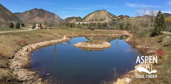
New Castle Geology – Marshes are Critical to Bird Life
The small marsh before you is an example of an intermittent wetland. During the year it can be dry or flooded depending on the amount of snowmelt and rainfall we receive and the level of the Colorado River nearby. Some wetlands are protected by federal law because they are critical habitat to migrating birds. Many bird species spend their winters in Central or South America, while breeding in the summer months here in North America. Several species of warbler, for instance, summer here and winter in Mexico.
Other bird species live here year round. Birds use marshy wetlands for shelter, breeding, rearing young, feeding, social interactions, and as a source of drinking water. Some predators also hang out around more isolated wetlands, lying in wait for a meal. Raccoon, mink, river otter, turtle, and snakes all use waterfowl such as ducks protect their young in the thick shelter which marshes offer. The more we protect wetland habitats like this marsh, the more birds and animals there will be.”


