Beaver Lake (7,945 ft)

1 Star2 Stars3 Stars4 Stars5 Stars6 Stars7 Stars8 Stars9 Stars10 Stars (31 votes, avg: 6.26 out of 10)
Loading...

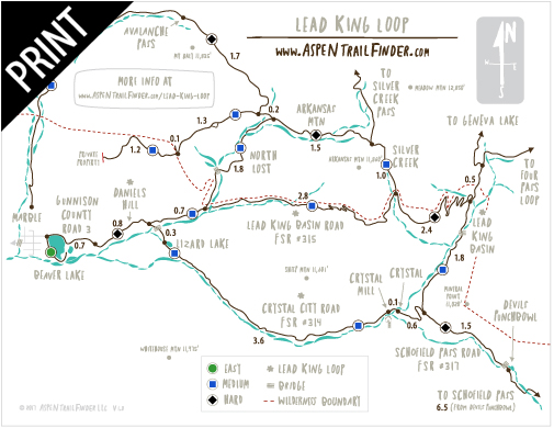
Connects: Aspen to Marble, Marble to Crested Butte, Gunnison County Road 3, Beaver Lake Trail, Crystal River

Camera_Icon_48Aspen Trail Finder Hiking TrailsAspen Trail Finder Running TrailsAspen Trail Finder Mountain Biking TrailsDog_Paw_Icon_48

Beaver Lake

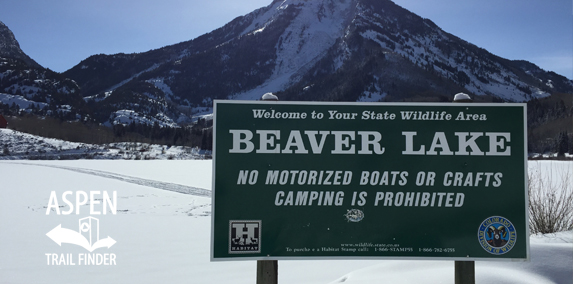
Snow covered Beaver Lake in the winter at Marble

Marble, CO – Lake

Beaver Lake (7,945 ft), also a State Wildlife Area, is a lake along Gunnison County Road 3 in Marble, CO. A trail wraps around the lake connected to the Crystal River.

Distances:
Highway 133/Gunnison County Road 3 Intersection to the lake – 6.6 Miles

More information about the lake can be found at:
Colorado Parks & Wildlife – Beaver Lake SWA

A sign about public access in Marble reads: (Click to expand)
“Attention – ATV/OHV/UTV Users

Use of the road past Beaver Lake, to Daniels Hill is a privilege, NOT a right!

By permission of the Board of County Commissioners the .7 of a mile of County Road #3 past the Beaver Lake Parking Lot, can be used by you to access public land. Show respect for local residents. Slow down and reduce noise or lost this right!”

Lead King Loop Trail MapLead King Loop Trail Map


View Larger Map

Comments

Subscribe
Notify of
guest
1 Comment
Inline Feedbacks
View all comments
Hadley Kate Cortez
Hadley Kate Cortez
9 months ago

What is the depth of beaver lake

Posted in Birding, Marble, Recreation Area, Sites, Wildlife Area Tagged with:

By using this site you agree to the terms of our User Agreement. Read our Disclaimer.

Trail Search

Find a trail. Use 1 or all 4 drop downs to customize your search for the right trail.

Dog Friendly:

  or  

Park Search

Find a park. Use the drop downs to find the perfect park.

Dog Friendly:

  or  

Featured and Mentioned On

Questions? Email us at info@aspentrailfinder.com
By using this site you agree to the terms of our User Agreement. Read our Disclaimer.