
Aspen and the Roaring Fork Valley have numerous wilderness areas surrounding them, most named after the fourteeners (peaks exceeding 14,000 feet in elevation) located in the area. Aspen Trail Finder covers the majority of the trails in seven of these wilderness areas – see our wilderness coverage area map. The wilderness areas covered below are managed by the White River National Forest, Gunnison National Forest, and San Isabel National Forest.
“We simply need that wild country available to us, even if we never do more than drive to its edge and look in. For it can be a means of reassuring ourselves of our sanity as creatures, a part of the geography of hope.” – Wallace Stegner
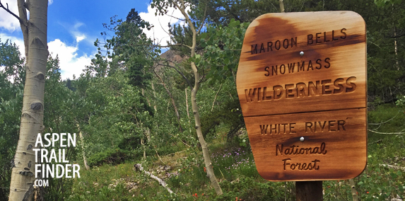
Maroon Bells-Snowmass Wilderness
The Maroon Bells-Snowmass Wilderness was one of the five original Colorado wilderness areas designated in 1964. Enlarged in 1980, it is now Colorado’s fourth largest wilderness area covering more than 180,000 acres. The area is named for the iconic Maroon Bells, two 14 foot peaks (Maroon Peak and North Maroon Peak) and another 14er, Snowmass Mountain.
Hunter-Fryingpan Wilderness
The United States Congress designated the Hunter-Fryingpan Wilderness in 1978 and it now has a total of 82,026 acres. This land contains the headwaters of Hunter Creek and the Fryingpan River.
Holy Cross Wilderness
Named after the Mount of the Holy Cross, the United States Congress designated the Holy Cross Wilderness in 1980 and it now has a total of 123,409 acres. This wilderness is managed by both the White River and San Isabel National Forest.
Collegiate Peaks Wilderness
The Collegiate Peaks Wilderness was designated by in 1980 and it now has a total of 167,584 acres. This area lies in part of three national forests; the White River, Gunnison and San Isabel. The wilderness is named for its’ eight 14ers (Mounts Yale, Oxford, Columbia, and Harvard, as well as Huron Peak, Missouri Mountain, Mount Belford, and La Plata Peak).
Mount Massive Wilderness
The Mount Massive Wilderness was designated by congress in 1980 and it now has a total of 30,540 acres. The area is named after the 14er, Mount Massive.
Flat Tops Wilderness
The United States Congress designated the Flat Tops Wilderness in 1975 and it now has a total of 235,214 acres. The Flat Tops are part of the White River Plateau with an average elevation of about 10,000 feet. The area has over 100+ lakes and ponds, many unnamed, surrounding the areas flat-topped cliffs.
Raggeds Wilderness
The United States Congress established the Raggeds Wilderness in 1980 and now covers 65,443 acres spanning the Gunnison and White River National Forests. The area is named Raggeds for its’ prominent rocky slopes that point upward to a serrated ridge.
Wilderness Regulations
Wilderness permits are required:
Most areas require visitors to obtain self-issued permits that are available at each trailhead at no cost. Permits are required in order measure the number of visitors in the Wilderness and educate Wilderness visitors about the benefits of minimizing impacts.
Nation-wide Wilderness regulations:
Motorized equipment and equipment used for mechanical transport is prohibited. This includes the use of motor vehicles, motorboats, motorized equipment, bicycles, hang gliders, wagons, game carts, portage wheels, and the landing of aircraft including helicopters.
Forest-wide Wilderness regulations:
All commercial and non-profit groups are required to obtain a Special Use Permit through the local ranger district office in advance of their trip. If you are using the services of an outfitter-guide, be sure they are licensed and have a Forest Service Permit.
Group size is limited to 15. Stock groups are limited to 25 with a maximum of 15 people.
Dogs must be under control at all times. Dogs can harass, stress, injure or kill wildlife, annoy fellow hikers and introduce disease. Some wilderness areas require dogs be leashed at all times.
Stock
Secure animals 100- feet away from lakes, streams, and trails. A picket line is less damaging to trees than direct tying. Move stock often when picketing to prevent resource damage.
Restraining or grazing of recreational livestock is not permitted within 100 feet of lakes or streams.
Only certified weed-free hay or pelletized food is allowed.
Camping
Camp sites must be at least 100 ft. from trails, lakes, streams, and any water source. Please use an existing site. Before leaving, ‘naturalize’ your campsite by removing signs of your use.
Obey posted signs prohibiting camping or other activities. Some campsites may be closed to allow the area to recover from overuse.
Trails
Cutting switchbacks in trails is prohibited. Shortcuts cause severe erosion, eventually destroying the trail.
Peak Climbers – Cross Country
Delicate alpine tundra is very susceptible to damage. Walk on durable routes of rock or talus. In the spring, travel on snow and rocks, or plan your trip during drier conditions.
Check with the local ranger district office on designated routes.
Waste
Soap, even biodegradable, pollutes the water. Dispose of wash water at least 100 feet away from any water source.
Bury human waste in a hole 6-8 inches deep a minimum of 100 feet away from any water source, trail, or campsite.
Pack out toilet paper, tampons, and leftover food. Otherwise, animals can dig it up. It is never acceptable to bury trash. Follow the rule: ‘if you pack it in, then pack it out.’
Campfires
A lightweight backpacking stove is recommended. If a campfire is desired, build it in a manner that minimizes impact. Campfires should be at least 100 feet from lakes, streams and trails. Collect only dead and downed wood that is less than three inches in diameter. Remember: if you can’t break it by hand, don’t use it.
Use existing fire rings. Avoid building fires above tree-line. Dead wood removed from Krummholz (dwarf trees near timberline) affects their survival.
Do not build a fire on exposed rock surfaces to prevent scarring.
If possible, use a fire blanket or a fire pan (like a pan used to change motor oil). Place several inches of soil in the bottom of the pan and build the fire on this. Always use extreme caution and avoid building fires in dry or windy conditions.
Minimum Impact Suggestions and Safety
All water can carry giardia, protozoa that affect the human intestinal system, and can cause serious illness. Water can be treated by boiling for 5 minutes, using iodine tables, or filtering.
Campfires are a tradition, but please consider their impacts:
Dead and downed wood is a component of the ecosystem.
Concentrations of charcoal and ash sterilize soil so consider using a fire pan.
Many visitors consider fire-rings an eyesore.
Repackage food items to minimize plastic trash that you will need to pack out.
Leave No Trace
Always practice Leave No Trace techniques.


