


 (20 votes, avg: 8.60 out of 10)
![]()
![]()
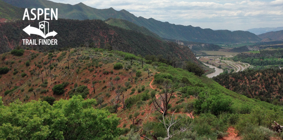
View from Storm King Mountain on the Storm King Fourteen Memorial Trail
Glenwood Springs, CO – Medium – 2 Miles – Hike – Dirt
The Storm King Fourteen Memorial Trail is an intermediate/moderate trail you can hike. The trail is in memory of the 14 firefighters who died there during the South Canyon Fire in 1994. This is a 2 mile dirt trail in Glenwood Springs, CO.
To get to the trailhead from Glenwood Springs, travel west on I-70 to Canyon Creek Exit 109. Turn right onto the frontage road. Going east, the trailhead is at the end of the road.
Distances:
Trailhead to Observation Point – 1 Mile
Trailhead to Memorial Site – 2 Miles
News about the Storm King Fourteen Memorial Trail can be found at:
Post Independent (May 21, 2014) – Storm King survivors share perspectives
Post Independent (July 6, 2010) – Storm King Fourteen Memorial Trail
Post Independent (July 5, 2004) – A fire’s legacy
Vail Daily (July 1, 2004) – Storm King’s legacy: training, communication
Post Independent (June 24, 2004) – Lessons learned from Storm King
More information about the Storm King Fourteen Memorial Trail can be found at:
Bureau of Land Management (BLM) – Storm King Mountain Memorial Trail
On July 6, 1994, Bureau of Land Management and U.S. Forest Service firefighters were attacking a small blaze ignited by lightning above the Colorado River near South Canyon Creek. They had reached the fire by parachute, helicopter and on foot. That afternoon a dry cold front moved through the area. Extreme winds whipped the blaze and the fire exploded. Trapped by steep slopes and dense vegetation, 14 firefighters were unable to escape and perished in the fire. Thirty-five others working higher on the ridge survived.
This trail is a memorial to those who died on Storm King Mountain, and to firefighters everywhere.
The City of Glenwood Springs is grateful to those who protect the community. In addition to this trail, volunteers have erected a monument to the firefighters in the city’s Two Rivers Park.“
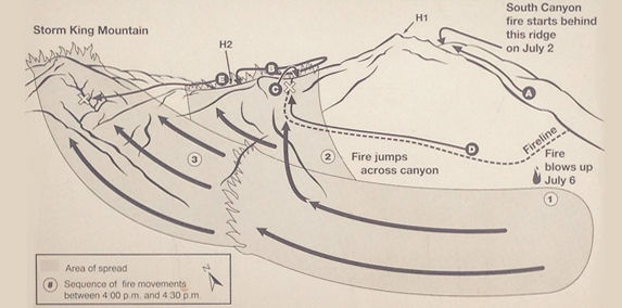
“July 6, 1994, on Storm King Mountain
At 4:30 a.m. on July 6, an 11-person Bureau of Land Management/Forest Service crew began their return hike to the South Canyon fire. They joined a team of eight smokejumpers who had spent the night fighting the slow-moving blaze. Both crews had begun fighting the fire the previous day. They continued clearing fireline and helicopter landing zones (Heliports H1 and H2 on diagram).
Later that morning, eight more smokejumpers and ten members of the hotshot crew arrived. They concentrated on clearing wireline between the two helispots and along the western flank of the fire. A helicopter with helitack crew assisted with water drops and reconnaissance flights. The remainder of the hotshot crew was flown to the ridge top at 3:00 p.m. and assigned to wireline work on the ridge.
As the day became warmer and winds increase, fire activity intensified and crews combatted several small spot fires that crossed the wireline. Steep terrain and dense vegetation made it difficult to see what the fire below was doing. At about 4:00 p.m. a dry cold front hit the area. Fanned by winds gusting to 45 miles per hour, the fire exploded. It jumped down-slope, and then began racing uphill at speeds up to 35 feet per second.
On the west flank of the fire, a smokejumper reported a spot fire below the wireline. Everyone was told to move toward safety routes. The smokejumpers (A) climbed uphill into a previously-burned area. In winds strong enough to blow off their hard hats, they climbed into their fire shelters. They remained there for one and a half hours as the fire burned nearby.
Crews on the ridge top (B) were told to move to the safety zone at Helispot 1. Cut off by the fire, they ran back along the ridge and down the east drainage to the highway. Several firefighters working near the ridge top (C) paused to encourage the crews coming up behind them before fleeing down the east drainage.
Hotshots and smokejumpers working the lower west flank (D) began moving back up the fireline. Unable to see the fire because of the dense oak brush canopy, they were trapped (X) when the fire jumped to the slope below them and flashed up the ridge. The two helitack crewmen at Helispot 2 (E) ran north and west along the ridge and were trapped (X) when the fire raced up the rocky slope.
In only five hours, the South Canyon fire consumed almost 2,115 acres. After one more small run, it was declared controlled on July 11.
In storm and cloud and wind and sky,
In heart and mind and hand and eye,
A bond still binds too strong to tell,
All those who fly with these who fell.
-Author unknown
Helitack: Grand Junction, CO
Rob Browning Marion, NC
Rich Tyler Palisade, CO
Smokejumpers: Missoula, MT
Don Mackey Hamilton, MT
Smokejumpers: McCall, ID
Roger Roth L’Anse, MI
Jim Thrash New Meadows, ID
Hotshots: Princeville, OR
Kathi Beck Boring, OR
Tami Bickett Lebanon, OR
Scott Blecha Clatskanie, OR
Levi Brinkley Burns, OR
Doug Dunbar McKenzie Bridge, OR
Terri Hagen Prineville, OR
Bonnie Holtby Redmond, OR
Rob Johnson Roseburg, OR
Jon Kelso Prineville, OR”


