


Connects: Dinkle Lake Road (FSR #311), Thomas Lakes Trail, Hay Park Trail, Thomas Lakes (10,200 ft), East Sopris Peak (12,965 ft), West Sopris Peak (12,965 ft)
![]()
![]()
![]()
![]()
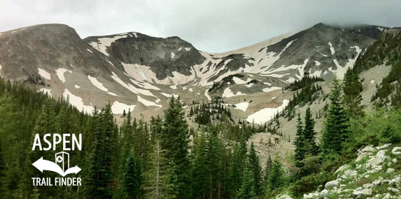
View of Mount Sopris in the Maroon Bells-Snowmass Wilderness
Basalt, Carbondale, CO – Hard – 7 Miles – Hike, Run, Dog Friendly – Dirt/Rocky
Mount Sopris Trail #1958 is a difficult trail you can hike and run that is dog friendly. This trail shares the first part with the Thomas Lakes Trail to Thomas Lakes (10,200 ft). From the lakes there Mount Sopris Summit Trail to East Sopris Peak and West Sopris Peak. This is a dirt/rocky trail in the Maroon Bells-Snowmass Wilderness near Carbondale, CO.
To get to the trailhead from Basalt take West Sopris Creek Road to Dinkle Lake Road, from Carbondale take Prince Creek Road to Dinkle Lake Road. Follow Dinkle Lake Road for 2 miles. The Mt. Sopris/Thomas Lakes trailhead will be on your right.
Distances:
Trailhead to Hay Park Trail – 1.75 Miles
Trailhead to Thomas Lakes (10,200 ft)/Wilderness Boundary – 3.75 Miles
Mt. Sopris Summit Trail/End of Thomas Lakes (10,200 ft) to East Sopris Peak (12,965 ft) – 2.75 Miles
More information about the Mount Sopris Trail can be found at:
White River National Forest – Mount Sopris Trail #1958 (Hiking)
White River National Forest – Mount Sopris 12,965 feet
Wikipedia – Mount Sopris
At 12,953 feet, Mount Sopris is the main feature of Carbondale’s southern landscape. It is part of the Elk Mountain Range and has two distinct summits located a half mile apart. Mount Sopris rises higher from base to peak than any other mountain in Colorado, more than 6700 feet above the valley floor.
The mountain was named after Captain Richard Sopris, who visited the area in 1860 on a mapping and gold exploration trip. The group traveled only as far as the base of the mountain, which they named “Sopris Peak” in honor of their expedition’s leader. The details that his group collected while exploring this area were used in creating the first maps of the Colorado Territory. Richard Sopris went on to be mayor of Denver and to serve for one year in the Civil War.”


i love hiking sopris! the views are amazing and thomas lakes are spectacular. there is great camping at thomas lakes and it does get rocky at the top!