Marble Airstrip (7,800 ft)

1 Star2 Stars3 Stars4 Stars5 Stars6 Stars7 Stars8 Stars9 Stars10 Stars (14 votes, avg: 6.29 out of 10)
Loading...

Connects: Crystal River, Gunnison County Road 3

Camera_Icon_48Aspen Trail Finder Walking Trails

marble airstrip

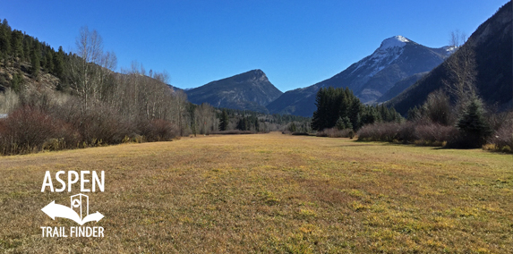
The Marble Airstrip jokingly referred to as Marble International Airport

Marble, CO – Airstrip

The Marble Airstrip (7,800 ft), jokingly referred to as Marble International Airport, is a 4,000 foot airstrip in a private field between the Crystal River and Gunnison County Road 3 in Marble, CO.

News about the airstrip can be found at:
Aspen Daily News (June 7, 2010) – Marble plane crash kills one, injures two
Aspen Daily News (April 21, 2005) – Pilot killed in Marble plane crash

More information about the airstrip can be found at:
Marble Tourism Association – Marble Airstrip


View Larger Map

Comments

Subscribe
Notify of
guest
0 Comments
Inline Feedbacks
View all comments
Posted in Marble, Sites, Viewing Area Tagged with:

By using this site you agree to the terms of our User Agreement. Read our Disclaimer.

Trail Search

Find a trail. Use 1 or all 4 drop downs to customize your search for the right trail.

Dog Friendly:

  or  

Park Search

Find a park. Use the drop downs to find the perfect park.

Dog Friendly:

  or  

Featured and Mentioned On

Questions? Email us at info@aspentrailfinder.com
By using this site you agree to the terms of our User Agreement. Read our Disclaimer.