Lead King Basin Road (FSR #315)

1 Star2 Stars3 Stars4 Stars5 Stars6 Stars7 Stars8 Stars9 Stars10 Stars (32 votes, avg: 9.13 out of 10)
Loading...

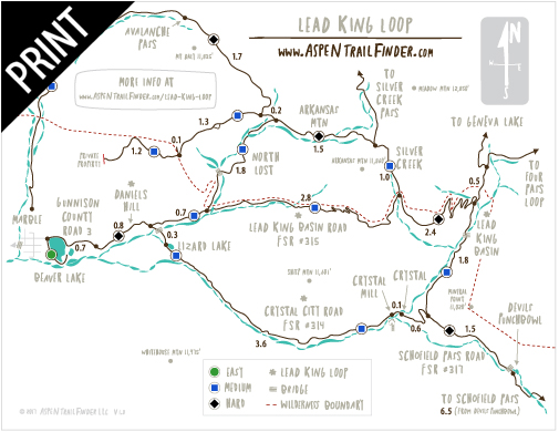
Connects: Gunnison County Road 3, Daniels Hill, Lead King Loop, North Lost Trail, Silver Creek Trail, Schofield Pass Road (FSR #317), Crystal City Road (FSR #314), Avalanche Pass Trail

Easy Aspen Hard TrailsHike_Icon_48Run_Icon_48Aspen Trail Finder Mountain Biking Trailshorse friendly trailDog_Paw_Icon_48

Lead King Basin Road

Lead King Basin Road (FSR #315) in Marble

Marble, CO – Hard – Hike, Run, Mountain Bike, Horseback Ride, Dog Friendly – Rocky

Lead King Basin Road (FSR #315), also called Lost Trail Road and Lead King Road, is an difficult Forest Service road you can hike, run, mountain bike, and horseback ride that is dog friendly. This road starts at the top of Daniels Hill and connects with Crystal City Road (FSR #314) to form the Lead King Loop. This is a rocky road near Marble, CO.

More information about Lead King Basin Road can be found at:
White River National Forest – Lead King Basin Loop Road #315 & #314 (4WD)

Lead King Loop Printable Trail MapLead King Loop Trail Map


View Larger Map

Comments

Subscribe
Notify of
guest
0 Comments
Inline Feedbacks
View all comments
Posted in 4-7 Miles, Difficult, Dirt, Dog Friendly, Expert, Hard, Hiking, Horseback Riding, Marble, Mountain Biking, Rocky, Running, Sheep Mountain, Trails Tagged with: , , , ,

By using this site you agree to the terms of our User Agreement. Read our Disclaimer.

Trail Search

Find a trail. Use 1 or all 4 drop downs to customize your search for the right trail.

Dog Friendly:

  or  

Park Search

Find a park. Use the drop downs to find the perfect park.

Dog Friendly:

  or  

Featured and Mentioned On

Questions? Email us at info@aspentrailfinder.com
By using this site you agree to the terms of our User Agreement. Read our Disclaimer.