


 (33 votes, avg: 8.70 out of 10)
Connects: Independence Pass Road (HWY 82), Independence Pass Scenic Trail, Continental Divide Trail (Independence Pass)
![]()
![]()
![]()
![]()
![]()
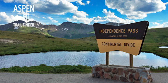
Independence Pass on the Continental Divide
Aspen, CO – Mountain Pass
Independence Pass (12,095 ft), originally called Hunter Pass, is a mountain pass along the Continental Divide accessed by Highway 82 that connects Aspen to Twin Lakes. A trail at the top provides a short paved loop from the parking area to scenic views of the Elk Mountains.
To get to the top of Independence Pass from Aspen go 19 miles up Independence Pass Road (HWY 82). The pass sign is located on the right, past mile marker 61. Restrooms are available at the top of the pass.
News about Independence Pass can be found at:
Herald Democrat (March 23, 2016) – Can this John Doe be identified?
Distances:
Top of Independence Pass to North Star Nature Preserve – 19 Miles
Top of Independence Pass to Twin Lakes – 17 Miles
More information about Independence Pass can be found at:
Wikipedia – Independence Pass (Colorado)
The Continental Divide is the topographic line that separates the Pacific and Atlantic Ocean drainages. The Divide in North America runs down the spine of the Rocky Mountains between Alaska and Mexico over the highest points between the drainages. At an elevation of 12,095’ above sea level, Highway 82 over Independence Pass is the highest paved road crossing of the Continental Divide in North America. This location also marks the boundary between Lake County and the Pike-San Isabel National Forest to the east, and Pitkin County and the White River National Forest to the west.
Lake Creek: The Grizzly Tunnel (right) brings water from the Roaring Fork and Lincoln Creek drainages under the Continential Divide to Lake Creek, the source of Twin Lakes. Changes in flow due to diversions has damaged both Lincoln and Lake Creeks.
Roaring Fork River: The Roaring Fork River is the second-largest tributary to the Colorado River in the State with some of its flow diverted east under the Continental Divide through the Twin Lakes Diversion System (photo right: Lost Man Diversion Canal).
The Broad Reach of the Divide: The Continental Divide is a geographic designation that runs along the highest points between Alaska and Argentina, separating the Atlantic and the Pacific watersheds. The land in North American west of the Divide drains to the Pacific Ocean while the land east of the Divide drains to the Atlantic Ocean.
The Snow Fence Experiment
In the mid-1960s, tons of snowfence were deposited and build around the Pass in an experiment to capture more winter snows and thereby increase water for runoff. The experiment failed and the snowfence was abandoned on the ridges surrounding the Pass.
The Independence Pass Foundation led a successful effort to remove the debris which was smothering out tundra plants and had been a hazard to hikers and skiers.
Did you know?
Water from the Divide eventually ends up in either the Pacific or Atlantic Ocean.”
The Independence Pass corridor is home to irreplaceable natural habitat, much of which is protected by federally-designated Wilderness Areas. Wilderness is off-limits to motorized recreation and mountain bikes but provides important low-impact recreational opportunities and is a sanctuary for native plants and animals. Wilderness designations also protect the unique tundra environment at the summit of Independence Pass. The tundra is home to specialized plants and animals which have adapted to the short growing season, harsh weather and extreme temperatures which characterize the highest life zones. Please stay on paths and trails to avoid damaging this fragile environment which can take decades to recover from disturbance.
What is “Wilderness?”
An area of undeveloped Federal land retaining its primeval character and influence, without permanent improvements or human habitation.
Excerpt from The Wilderness Act of 1964
Wilderness: The Independence Pass corridor is surrounded by federally designated Wilderness, which excludes development and motorized use within its boundaries. The Pass is home to many species of flora and fauna that are vulnerable to human disturbance, so Wilderness protection is vital to ecological health.”


