

 (44 votes, avg: 9.41 out of 10)
Connects: Anderson Park, Snyder Park Trail, East of Aspen Trail, North Star Nature Preserve, North Star Beach, Difficult Trail, Weller Lake Trail, Weller Campground, Devil’s Punchbowl, Grottos Trail, Lincoln Creek Road (FSR #106), Braille Trail, Discovery Trail, Lost Man Campground, Midway Creek Trail, Lost Man Trail, Green Mountain Trail, Independence Ghost Town, Linkins Lake Trail, Independence Pass (12,095 ft), Independence Pass Scenic Trail, Continental Divide Trail, North Fork Trail, La Plata Gulch Trail, Twin Lakes (9,195 ft)
![]()
![]()
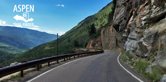
A very narrow section along Independence Pass Road
Aspen, CO – Hard – 36 Miles (Aspen to Twin Lakes) – Road Bike – Paved
Independence Pass Road, part of Highway 82, is a difficult road you can road bike. This section of State Highway 82 (Aspen to Leadville) is part of the Top of the Rockies Scenic and Historic Byway. Independence Pass is at an elevation of 12,095 ft on the Continental Divide and is the highest paved pass in Colorado. It is a 19 mile paved road from Aspen to the top of the pass. There are restrooms and a sign at the top. It is 17 miles from the top of Independence Pass down to Twin Lakes.
Independence Pass Road is typically closed to vehicular traffic between November 1 and the start of the Memorial Day Weekend. In the fall, Colorado Department of Transportation (CDOT) closes Independence Pass Road (Highway 82) depending on snow accumulation. The winter gate closure typically occurs in November, before Thanksgiving. Independence Pass Road reopens every year around the start of Memorial Day Weekend.
Distances:
North Star Nature Preserve to the Top of Independence Pass (12,095 ft) – 19 Miles
Top of Independence Pass (12,095 ft) to Twin Lakes – 17 Miles
More information about Independence Pass can be found at:
Independence Pass Foundation – www.independencepass.org
Top of the Rockies Scenic and Historic Byway – www.topoftherockiesbyway.org
Wikipedia – Independence Pass (Colorado)
The first travelers over Independence Pass came from the east because most of western Colorado was Indian territory until the relocation of the White River Utes in 1881. Prospectors from the Leadville area explored the Roaring Fork Valley in the 1870s but the first records of travel over the Pass come from 1879, when prospectors found gold near the Independence Ghost Town. Mining fueled the development of a toll road over the Pass and mineral development thrived for a number of years until the ore played out. The road fell into disrepair until the State of Colorado designated State Highway 82 over the Pass in the 1920’s and rebuilt the road on its current alignment. Remnants of the original road and the way stations that serviced it can still be found alongside the current highway. Ruins of old mines and cabins are scattered throughout the woods and valleys of the Pass.
The stretch of road known as “The Narrows” just below the Weller Campground has always brought thrills of terror. Steep drop-offs, loose rock, narrow roadways and changeable weather made early travel a risky undertaking. Even today the road can be treacherous, particularly during early spring and late fall when cold temperatures can cause icing.
The original road over the Pass featured long stretches of “corduroy” where logs were laid down to counter the effects of water, mud and soft soils. Original corduroy logs can still be found next to Highway 82, just east of the summit on the north side.
Originally, travel over the Pass was on foot paths worn by Native Americans, prospectors and pack animals. In 1881-82 a toll road was built over the Pass. The road saw heavy traffic from wagons, horses and foot travelers until the railroads came to Aspen in 1887. The remains of the old road can still be found at various locations along the Pass.
The road over the Pass was sometimes crowded even before Aspen became a popular tourist destination. This photo shows a funeral procession pausing at the top of the Pass in 1930.
1900s
Citizens of Aspen turned out for “Good Roads Day” every springs to open the Pass
2014
Modern snow removal is still dangerous. Opening the Pass on Memorial Day weekend is always CDOT’s goal.
Did you know?
The original toll road (1882-87) over the Pass was open all year round.”
Early Settlers
Prospectors from Leadville first journeyed over Independence Pass in the winter of 1879. When precious metals were discovered at the Independence Town Site, miners and settlers followed, making the Pass a well-worn trail into the area.
Historic Passage
The Roaring Fork Valley, once the summer hunting grounds of native Ute Indians, became a major mining district during the 1880s. Sections of an early toll road that carried pioneers and early settlers over the Pass are still visible on the steep slopes opposite this viewing area (*just below the upper parking lot for Lost Man Trail).”
![]()
![]()
![]()
![]()
![]()
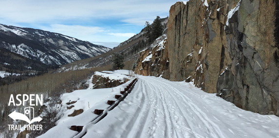
A narrow section on Independence Pass Road in winter
Aspen, CO – Easy – 40 Miles (14 miles to top of Independence Pass) – Snowshoe, Classic XC Ski, Fat Bike, Dog Friendly – Snow
Independence Pass Road is an easy winter road you can snowshoe, classic cross-country ski, and fat bike that is dog friendly. This is a 40 mile winter road closure near Aspen, CO. The gate closure is located about 6 miles east of Aspen from the North Star Nature Preserve. This is not a groomed nordic trail.
Distances:
Winter Gate Closure to Weller Lake Trailhead – 2.25 Miles
Winter Gate Closure to Grottos Trailhead – 3.35 Miles
Winter Gate Closure to Lincoln Creek Road (FSR #106) – 4.25 Miles
Winter Gate Closure to Braille/Discovery Trailhead – 6.7 Miles
Winter Gate Closure to Lower Lost Man Trailhead – 8 Miles
Winter Gate Closure to Independence Ghost Town – 9.9 Miles
Winter Gate Closure to Upper Lost Man Trailhead – 12.1 Miles
Winter Gate Closure to the top of Independence Pass (12,095 ft) – 14 Miles
More information about winter on Independence Pass Road can be found at:
White River National Forest – Independence Pass (XC Ski)


