

 (38 votes, avg: 9.32 out of 10)
Connects: Highway 82, Carbondale (6,180), Carbondale to Crested Butte, Red Hill, Roaring Fork River, Bob Terrell State Wildlife Area, Veterans Memorial Bridge, Crystal Valley Trail, Rio Grande Trail, Rio Grande ARTway, Derail Park, Thompson House Museum History Park, Jail and Cabin History Park, Bonnie Fischer Park, River Valley Ranch Park (Triangle Park), Prince Creek Road (CR 111), Nuche Park, Perham Creek Trail, Janeway (Mobley’s Camp), Avalanche Creek Road (FSR #310), The Narrows Trail, Penny Hot Springs, Redstone (7,200 ft), Elk Park, Redstone Coke Ovens, Coal Creek Road (FSR #307), Redstone Castle, Hayes Creek Falls, Placita Trail, Marble (7,990 ft), Gunnison County Road 3, Huntsman Ridge Road (FSR #517), McClure Pass (8,755 ft), Ragged Mountain Road (FSR #898), Drift Creek Trail
![]()
![]()
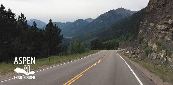
The Elk Mountains looking toward Marble on Highway 133
Carbondale, Redstone, Marble, CO – 205 Miles – Road Bike – Paved
Highway 133 begins at the traffic light along Highway 82 at Carbondale. This highway is part of the West Elk Loop Scenic and Historic Byway, a 205 mile, lasso shaped series of roads (Highway 133, Highway 92, and Highway 135) around the West Elk Mountains. This two-lane highway goes through rural and historic Western Colorado, passing 3 wilderness areas and several mining towns. The section of the byway through Marble, Redstone, and Carbondale is referred to as the Ruby Route.
Distances:
Highway 82/Highway 133 intersection to McClure Pass – 26 Miles
More information about the West Elk Loop Scenic Byway is available at:
www.westelkbyway.com – West Elk Byway
Colorado Department of Transportation (CDOT) – West Elk Loop
Visit Colorado – Colorado’s Scenic Byway: West Elk Loop
Carbondale…
Having celebrated its Centennial in 1987, Carbondale has variously been a railroad, farming and coal center during its 100-year history. Carbondale today is a multi-faceted town of some 3600 people.
Under the shadow of Mount Sopris, the Ute Indians once spent their summers in the Valley in pursuit of the ever-plentiful fish and game needed for food, clothing and shelter. Later, each fall they left the high country. They were an isolated and peaceful people at the time of the earliest contact with the white man.
To acquire more land for settlement, Colorado governors negotiated treaties with the Utes in 1863 and 1868. The treaties were quickly put aside as dreams of riches clouded the memories of the white men. A new treaty was drawn up expelling the Utes from the area and forcing them onto desert reservations in the Four
In November 1887, the railroad arrived with much celebration, and scheduled a stop in Carbondale. Railroad construction and mining activity up valley in Marble and Redstone brought many workers and investors. The Railroad transported minerals to market and miners to town for supplies and good times. Numerous saloons, a bank, a mercantile company and a drug store opened. Carbondale was growing rapidly.
Carbondale has always been considered garden spot and early settlers found it ideal for potato growth. The activity generated by the popular tuber sustained the community, with cattle and sheep ranches reinforcing the economy.
In the early 1900’s the Roaring Fork Potato Growers’ Association was organized. With potato farming a thriving business, locals began the annual Potato Day Celebration in 1909. Every fall locals still celebrate with a parade of dancing potatoes, a bareback gymkhana and an old-fashioned picnic in the park.
Fire was the bane of Western frontier towns, and Carbondale was no exception. In November 1891, a large fire destroyed almost all of the business section of Carbondale. However, the safe of the Bank of Colorado, (which opened for business in the Dinkel store in 1888), was saved and the bank was operating the next day. Most of the businesses were re-built further west on Main Street. Dinky put up his brick building which still stands, and added the second story the next year.
In 1893, fire destroyed two entire blocks of businesses as it did in 1896 when the Hotel Alcorn was destroyed by flames. An 1898 fire engulfed a saloon, butcher shot, restaurant and rooming establishments; they were quickly replaced. Flames fro this fire could be seen fro miles as it devoted the downtown section.
While other Crystal River Valley boom towns from the turn of the century fell into oblivion during the decline of mining, Carbondale merely dwindled. In 1908, Carbondale had 300 residents.
During the Depression the bank moved to Glenwood Springs, the railroad quit running, and the population declined. Mining became secondary to farming and ranching as the basis of the area economy. The community fared comfortably through the fifties.
During the sixties the impact of Aspen’s growth as a ski town and cultural center began to be felt. Tourist-related activities began, employment opportunities increase, and property values soared. The population grew and subsequently ranch and farm lands were subdivide into home sites.
In 1960, only 450 people lived here, while the 1970 census counted 750 residents. By 1981, the population of Carbondale, inside its incorporated limits had surpassed 2,000. Today, Carbondale is primarily a quality residential community serving the business interests of the valley. Local businesses provide community services, there are many self-employed tradespeople and artisans, with tourism and construction companies the substantive basis of the local economy.
Remnants of the life of farming and ranching that once was the mainstay of the Valley. Cattle and sheep ranching is still evident in the areas surrounding Carbondale, with cowboys at cattle roundups, spring calving and irrigator boots still part of the culture of the valley.”
You’ll be mesmerized. Its clear, cold waters come from high mountain snowpacks, underground springs and towering waterfalls. The Crystal reminisces as it passes ghost towns, mining claims, marble quarries, hot springs and dude ranches. An abandoned 1800’s railroad be travels along side. Although the steel rails are gone today, the ghosts of runaway trains and hard-working men and women are still here. See the spilled blocks of white marble scattered in the river along your way up Highway 133. Who can know all the exciting moments and tragic wrecks that are marked by these white marble tombstones?
And how’s the fishing you ask? Gold medal trout love these crystal waters. Just out of Carbondale on the right, there’s even a fish hatchery, loaded with thousands of beautiful rainbows and german browns, just awaiting release into the Crystal River and your creel. An incredible amount to see and enjoy. Stop first at our Carbondale Chamber and ask them where their favorite fishing hole is!”
Crystal River Valley
You will be entranced every inch of the 30 mile drive up Highway 133 as it climbs from 6,180 feet here in Carbondale to 8,755 feet atop the gorgeous McClure Pass. Though the trip is pure pleasure, at the top, stop and turn around for the icing on the cake. Take a moment to be inspire. Steep cliffs, narrow canyons, heavy forests and shimmering aspens. Keep your eyes sharp for deer, bear, bighorn sheep, and the comical and ever-curious marmot.
What do you like to do? There’s hiking, biking, four-wheeling, horseback riding, fishing, camping, backpacking and wild flower viewing. Get river-bound in kayaks or whitewater rafts. This is what life is all about!
Is there snow on the ground? There’s skiing, skating, snowshoeing, and some of the most remarkable snowmobiling you will experience in your lifetime!”
Ancestors of the Ute peoples migrated into this area as long as 1000 years ago. They moved with the seasons, traveling in small family groups to hunt big game and harvest edible plants. As they traveled, they built expandable shelters from wooden limbs and poles covered with bark and brush, or animal skins. They possessed only what they could carry. All of nature was sacred to the Utes and their practical, efficient lifeways had sustained countless generations of their ancestors.
Beginning in the 17th century, Ute groups in western Colorado began to adopt horse culture and other European influences. With the horse, their nomadic way of life flourished, and for more than a century they were a dominant presence in Western Colorado. But as settlers flooded into the Rockies in the mid-1800s, the Utes’ traditional hunting and gathering grounds began to disappear. In 1881 the last northern Colorado Utes, including those in the valleys of the Crystal and Roaring Fork Rivers, were banished to reservations in the deserts of easter Utah.”


