

 (50 votes, avg: 9.08 out of 10)
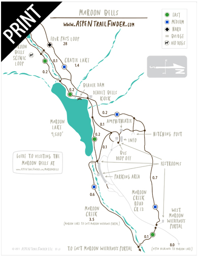
Connects: Aspen High School, Aspen Recreation Center, Maroon Creek Trail, Terral Wade Bridge (Tieback Nordic Bridge), Aspen Highlands, Silver Bar Campground, Silver Queen Campground, East Maroon Wilderness Portal, Maroon Creek Trail (Maroon Bells), East Maroon Trail, West Maroon Wilderness Portal, West Maroon Portal Trail, Maroon Lake (9,585 ft), Maroon Bells Scenic Trail
![]()
![]()
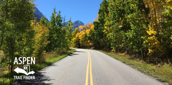
Fall leaves along Maroon Creek Road
Aspen, CO – Medium – 9.25 Miles – Road Bike – Paved
Maroon Creek Road (CR 13) is an intermediate/moderate road you can road bike that leads to the Maroon Bells Scenic Area. This is a 9.25 mile paved road in Aspen, CO.
Distances:
Aspen Highlands Village to Maroon Lake – 8 Miles
News about Maroon Creek Road can be found at:
Aspen Daily News (October 9, 2015) – RFTA mulls rise in fare to the Bells
More information about the Maroon Bells can be found at:
Visiting the Maroon Bells
![]()
![]()
![]()
![]()
![]()
![]()
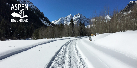
Maroon Creek Road in winter
Aspen, CO – Easy – 6.4 Miles – Snowshoe, Classic XC Ski, Skate Ski, Fat Bike, Dog Friendly – Snow
Maroon Creek Road is an easy winter road you can snowshoe, classic cross-country ski, skate ski, and fatbike that is dog friendly. This is a 6.4 mile winter road closure from T-Lazy-7 Ranch to Maroon Lake with views of the Maroon Bells in Aspen, CO. This road is typically a groomed nordic trail when conditions allow.
Distances:
Winter Road Closure from T-Lazy-7 Ranch to Maroon Lake – 6.4 Miles
Kilometer signs typically mark the snowy road – 9 signs total
To get to the road closure from the Aspen round-a-bout, take a right onto Maroon Creek Road. Follow the road 3.2 miles to a parking area just past T-Lazy-7 Ranch.
More information about Maroon Creek Road can be found at:
White River National Forest – Maroon Creek Road (XC Skiing)
More information about the Maroon Bells can be found at:
Visiting the Maroon Bells
Avalanches present serious winter mountain hazards, and Colorado’s mountains produce some of the worst avalanche conditions on the continent. In a typical Colorado winter, at least 20,000 avalanches occur in places where heavy snow accumulations combine with unstable snowpack. The Maroon Valley experiences many avalanches over the course of the winter.
The start of an avalanche can become apparent in many ways: with a quiet whump, with drum-like sounds, or with a sudden appearance of shooting cracks in the snow’s surface. An avalanche can be triggered by the snap of a twig, by normal conversation, or by a light footstep on a weak patch of snow. Although avalanche paths can often be seen on open slopes, slides also occur on hillsides covered with trees and other vegetation.
From the moment it starts, an avalanche moves hard and fast, with the roar and power of a locomotive. It can travel faster than 100 m.p.h. It tumbles boulders like toys and topples large trees, pulling them downhill. No one can predict when or where an avalanche will happen, but training in avalanche awareness allows humans to minimize the risk of hiking, skiing, and climbing in the backcountry.
In a forest environment, avalanches clear the landscape, create open spaces, and allow new trees to establish. As in burned-over areas, aspens often fill in along an avalanche path. Aspens, with their flexibility and small diameter trunks, often survive avalanches better than most conifers.”


If you enjoy getting passed by 50+ snowmobiles per hour then you’ll love this trail.