Connects: Highway 82, Roaring Fork River Aspen, CO – Hard – Hike, Dog Friendly – Rocky/Dirt The Airport Ranch Trail a difficult trail network providing fishing access to the Roaring Fork River you can hike that is dog friendly. This…

Connects: Highway 82, Roaring Fork River Aspen, CO – Hard – Hike, Dog Friendly – Rocky/Dirt The Airport Ranch Trail a difficult trail network providing fishing access to the Roaring Fork River you can hike that is dog friendly. This…
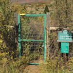
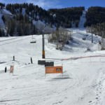
Connects: Alpine Springs Lift Snowmass Village, CO – Hard – Uphill, Snowshoe, Dog Friendly – Snow Alpine Springs Uphill Route is a difficult route you can skin and snowshoe up that is dog friendly. This is an uphill route on…
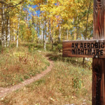
Connects: Snowmass Loop, Tom Blake Trail, Tom Blake Equestrian Trail, Terminator Trail (Winter), Government Trail Snowmass Village, CO – Hard – 0.6 Miles – Hike, Run, Mountain Bike, Dog Friendly – Dirt Anaerobic Nightmare Trail is a difficult trail you…

Connects: Snowmass Bike Park, Elk Camp Gondola, Vapor Trail (Downhill Only) Snowmass Village, CO – Hard – 1.9 Miles – Mountain Bike – Dirt The Animal Crackers Trail is a difficult downhill only mountain biking trail in Snowmass Village, CO.…
Connects: North Anthracite Trail, Yule Creek Trail, Raspberry Creek Trail Marble, CO – Hard – Hike, Run, Horseback Ride, Dog Friendly – Rocky/Dirt Anthracite Pass Trail #1969 is a difficult trail you can hike, run, and horseback ride that is…
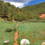
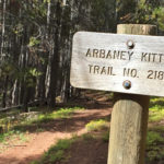
Connects: Arbaney Traverse, Arbaney Kittle West Trail, Arbaney Kittle Trail Basalt, CO – Hard – 1.15 Miles – Hike, Mountain Bike, Dog Friendly – Dirt Arbaney Kittle Gulch Trail is a difficult trail you can hike and mountain bike that…
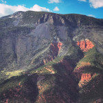
Connects: Arbaney Traverse, Basalt/Old Snowmass Trail, Arbaney Kittle West Trail, Arbaney Kittle Gulch Trail, Fryingpan Overlook (8,290 ft), Triangle Peak Trail, Red Rim Road (FSR #534), Red Canyon Trail, Kobey Trail Basalt, CO – Hard – 17.5 Miles – Hike,…
Connects: Arbaney Traverse, Arbaney Kittle Gulch Trail, Arbaney Kittle Trail, Fryingpan Overlook (8,290 ft) Basalt, CO – Hard – 1.95 Miles – Hike, Run, Mountain Bike, Dog Friendly – Dirt Arbaney Kittle West Trail is a difficult trail you can…
Connects: Basalt/Old Snowmass Trail, Arbaney Kittle Trail, Arbaney Kittle West Trail, Arbaney Kittle Gulch Trail, Fryingpan Overlook (8,290 ft), Triangle Peak Trail, Red Rim Road (FSR #534), Triangle Peak (9,223 ft), Red Canyon Trail, Kobey Trail, Forest Service Road #513,…
Connects: Lead King Loop, Lead King Basin Road (FSR #315), Silver Creek Trail, North Lost Trail, Carbonate Creek Trail Marble, CO – Hard – 5.2 Miles – Hike, Run, Horseback Ride, Dog Friendly – Dirt Arkansas Mountain Trail #1965 is…
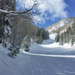
Connects: Exhibition Lift Aspen, CO – Hard – Uphill, Snowshoe – Snow Aspen Highlands Uphill Route is a difficult route you can skin and snowshoe up. This is an uphill trail on Aspen Highlands Mountain in Aspen, CO. This route…
Connects: Silver Queen Gondola Aspen, CO – Hard – Uphill, Snowshoe – Snow Aspen Mountain Uphill Route is a difficult route you can skin and snowshoe up. Uphillers must turn around at 9 a.m., if they are not at the…
Connects: Maroon Creek Road (CR 13), Maroon Creek Trail, Maroon Lake (9,585 ft), Maroon Bells Scenic Trail, Four Pass Loop, Crater Lake Trail, Crater Lake (10,076 ft), West Maroon Trail, West Maroon Pass (12,465 ft), East Maroon Trail, East Maroon…
Connects: Marble to Crested Butte, Four Pass Loop, Maroon Lake (9,585 ft), Buckskin Pass (12,462 ft), Snowmass Lake (10,980 ft), Trail Rider Pass (12,415 ft), Geneva Lake (10,940 ft), Lead King Loop, Beaver Lake (7,945 ft) Aspen, Marble, CO –…
Connects: Lead King Loop, Lead King Basin Road (FSR #315), North Lost Trail, Carbonate Creek Trail, Buckskin Basin, Avalanche Pass (12,100 ft) Marble, CO – Hard – 3.7 Miles – Hike, Run, Horseback Ride, Dog Friendly – Dirt Avalanche Pass…


